File:Dust Storm Over Turkmenistan.jpg
Jump to navigation
Jump to search

Size of this preview: 800 × 531 pixels. Other resolutions: 320 × 212 pixels | 640 × 425 pixels | 1,024 × 680 pixels | 1,280 × 850 pixels | 3,072 × 2,039 pixels.
Original file (3,072 × 2,039 pixels, file size: 911 KB, MIME type: image/jpeg)
Captions
Captions
Add a one-line explanation of what this file represents
Summary[edit]
| Description |
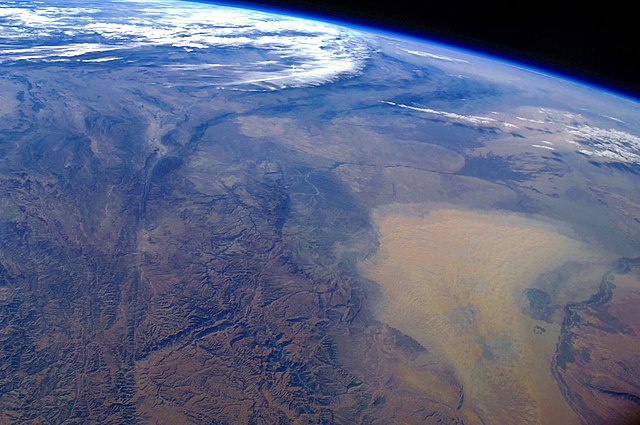
English: This west-looking astronaut photograph, taken with a short focal length lens from the International Space Station, spans a wide swath of central Asia—from Afghanistan, along the length of Turkmenistan, and beyond to the Caspian Sea. Winds blowing down the largest river valley in the region, the Amudarya, were strong enough to raise a large dust storm. Dust appears as a light brown mass extending into the center of the image from the lower right. Diffuse dust from prior windy weather appears over much of the area making a regional haze that hides landscape details. The haze partly obscures the irrigated agriculture in Turkmenistan and entirely obscures the Caspian Sea. Numerous rivers rise in the Hindu Kush range (lower left). The Band-i Amir River is a major tributary of the main regional river, the Amudarya, which it reaches via a deep canyon. The Amudarya River was the major historical contributor of water to the Aral Sea, but today extensive diversion of river water for agricultural purposes has led to desiccation of the sea bed. The exposed sea bed is a major source of saline dusts contaminated with agricultural chemicals, and it poses a significant environmental and human health hazard to central Asia. To a lesser extent, dusts are also mobilized from sediments along the Amudarya River channel. The Paropamisus Range and the Amudarya (also known as the Oxus River) are mentioned in histories of Alexander the Great’s famous military expedition from Greece to India. His horsemen are described as having made a fast side excursion from near the Caspian Sea (image top right) as far as the Amudarya (image lower right).
|
||||||||||||||||||||||||||||||||||||||||||||||||||
| Date | |||||||||||||||||||||||||||||||||||||||||||||||||||
| Source | NASA Earth Observatory | ||||||||||||||||||||||||||||||||||||||||||||||||||
| Author | This image was taken by the NASA Expedition 17 crew. | ||||||||||||||||||||||||||||||||||||||||||||||||||
| Camera location | | View this and other nearby images on: OpenStreetMap |
|---|
Astronaut photograph ISS017-E-19616 was taken with a Nikon D2Xs digital camera fitted with a 28 mm lens, and is provided by the ISS Crew Earth Observations experiment and Image Science & Analysis Laboratory, Johnson Space Centre.
This image or video was catalogued by Johnson Space Center of the United States National Aeronautics and Space Administration (NASA) under Photo ID: ISS017-E-19616. This tag does not indicate the copyright status of the attached work. A normal copyright tag is still required. See Commons:Licensing. Other languages:
|
Licensing[edit]
| This file is in the public domain in the United States because it was solely created by NASA. NASA copyright policy states that "NASA material is not protected by copyright unless noted". (See Template:PD-USGov, NASA copyright policy page or JPL Image Use Policy.) | ||
 |
Warnings:
|
File history
Click on a date/time to view the file as it appeared at that time.
| Date/Time | Thumbnail | Dimensions | User | Comment | |
|---|---|---|---|---|---|
| current | 09:39, 18 January 2011 | | 3,072 × 2,039 (911 KB) | Originalwana (talk | contribs) | higher res |
| 14:56, 26 April 2009 |  | 1,440 × 960 (597 KB) | Originalwana (talk | contribs) | {{Information |Description={{en|1=This west-looking astronaut photograph, taken with a short focal length lens from the International Space Station, spans a wide swath of central Asia—from Afghanistan, along the length of Turkmenistan, and beyond to the |
You cannot overwrite this file.
File usage on Commons
The following 2 pages use this file:
File usage on other wikis
The following other wikis use this file:
- Usage on bn.wikipedia.org
- Usage on en.wikipedia.org
- Usage on en.wikiquote.org
- Usage on id.wikipedia.org
- Usage on it.wikipedia.org
- Usage on kn.wikipedia.org
- Usage on ms.wikipedia.org
- Usage on sq.wikipedia.org
- Usage on sr.wikipedia.org
- Usage on ta.wikipedia.org
- Usage on tr.wikipedia.org
- Usage on uk.wikipedia.org
- Usage on vi.wikipedia.org