File:Abbasid Caliphate 850AD.png
Jump to navigation
Jump to search
Size of this preview: 800 × 497 pixels. Other resolutions: 320 × 199 pixels | 640 × 398 pixels | 1,024 × 637 pixels | 1,280 × 796 pixels | 2,163 × 1,345 pixels.
Original file (2,163 × 1,345 pixels, file size: 798 KB, MIME type: image/png)
Captions
Captions
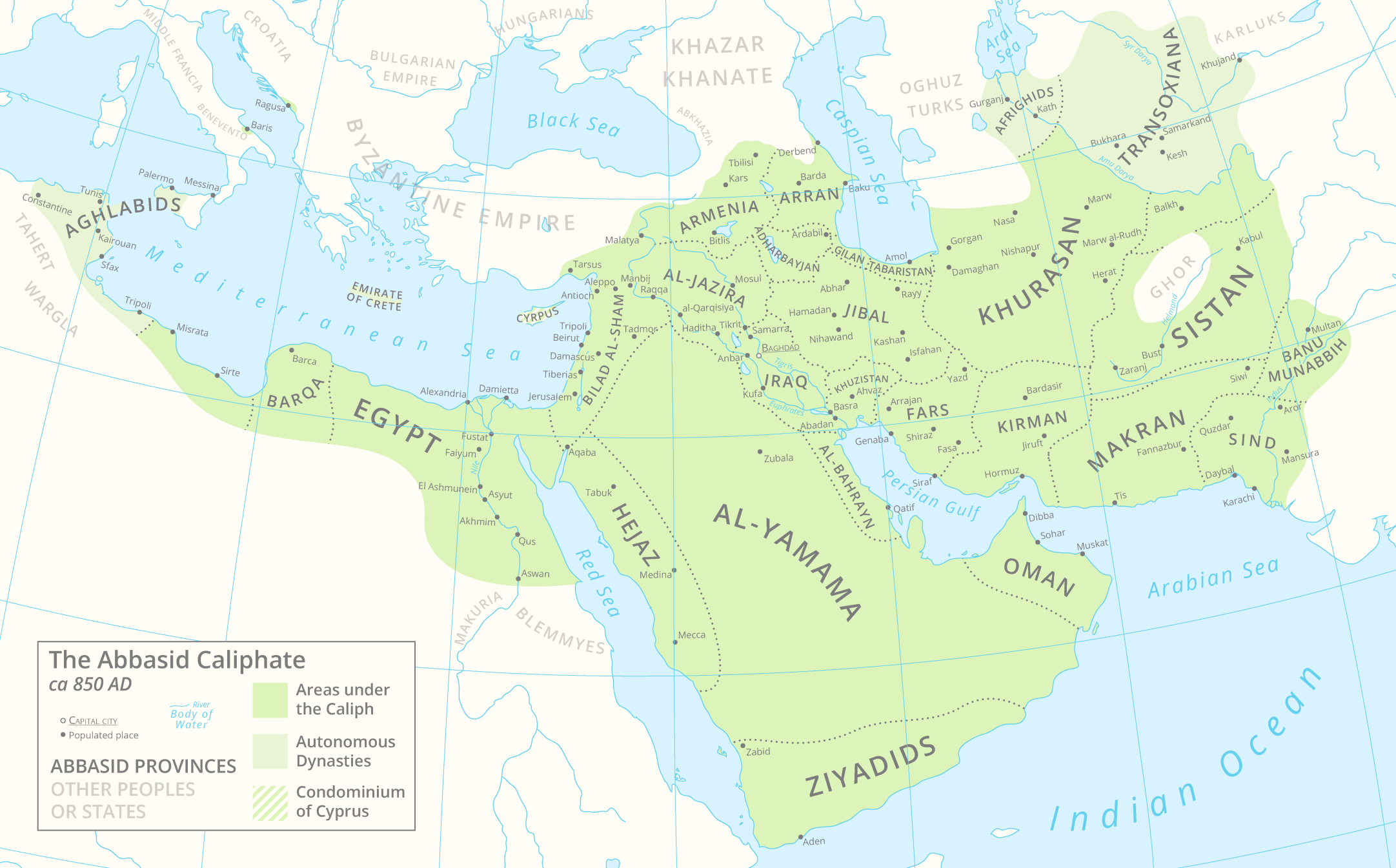
A map of the Abbasid Caliphate around 850 AD featuring provinces and settlements.
Summary[edit]
| Description |
English: A map of the Abbasid Caliphate around 850 AD featuring provinces and settlements. |
| Date | |
| Source |
Own work.
This PNG graphic was created with Adobe Illustrator. |
| Author | Cattette |
| Other versions | العربيَّة |
Licensing[edit]
I, the copyright holder of this work, hereby publish it under the following license:
This file is licensed under the Creative Commons Attribution 4.0 International license.
- You are free:
- to share – to copy, distribute and transmit the work
- to remix – to adapt the work
- Under the following conditions:
- attribution – You must give appropriate credit, provide a link to the license, and indicate if changes were made. You may do so in any reasonable manner, but not in any way that suggests the licensor endorses you or your use.
File history
Click on a date/time to view the file as it appeared at that time.
| Date/Time | Thumbnail | Dimensions | User | Comment | |
|---|---|---|---|---|---|
| current | 13:05, 29 March 2021 | | 2,163 × 1,345 (798 KB) | Cattette (talk | contribs) | Tweaked provinces, added Arabia |
| 08:13, 17 March 2021 |  | 2,163 × 1,052 (691 KB) | Cattette (talk | contribs) | Tweaked provinces | |
| 12:05, 16 March 2021 |  | 2,163 × 1,052 (690 KB) | Cattette (talk | contribs) | More provinces | |
| 06:10, 15 March 2021 |  | 2,163 × 1,052 (666 KB) | Cattette (talk | contribs) | Added more cities, removed the Canal of the Pharaohs, added more divisions | |
| 21:48, 10 March 2021 |  | 2,105 × 1,052 (508 KB) | Cattette (talk | contribs) | Uploaded own work with UploadWizard |
You cannot overwrite this file.
File usage on Commons
The following 5 pages use this file:
File usage on other wikis
The following other wikis use this file:
- Usage on ar.wikipedia.org
- Usage on ast.wikipedia.org
- Usage on az.wikipedia.org
- Usage on bn.wikipedia.org
- Usage on ca.wikipedia.org
- Usage on cs.wikipedia.org
- Usage on de.wikipedia.org
- Usage on diq.wikipedia.org
- Usage on el.wikipedia.org
- Usage on en.wikipedia.org
- Usage on es.wikipedia.org
- Usage on eu.wikipedia.org
- Usage on fa.wikipedia.org
- Usage on fi.wikipedia.org
- Usage on ga.wikipedia.org
- Usage on gl.wikipedia.org
- Usage on ha.wikipedia.org
- Usage on ia.wikipedia.org
- Usage on ko.wikipedia.org
- Usage on lt.wikipedia.org
- Usage on lv.wikipedia.org
- Usage on mg.wikipedia.org
- Usage on mn.wikipedia.org
- Usage on ms.wikipedia.org
- Usage on pnb.wikipedia.org
- Usage on pt.wikipedia.org
- Usage on ro.wikipedia.org
- Usage on shi.wikipedia.org
- Usage on sq.wikipedia.org
- Usage on ta.wikipedia.org
- Usage on th.wikipedia.org
- Usage on tr.wikipedia.org
- Usage on uk.wikipedia.org
View more global usage of this file.