File:Nuclear power plants map Ukraine-fr.png
Jump to navigation
Jump to search
No higher resolution available.
Nuclear_power_plants_map_Ukraine-fr.png (634 × 324 pixels, file size: 78 KB, MIME type: image/png)
Captions
Captions
Add a one-line explanation of what this file represents
Summary[edit]
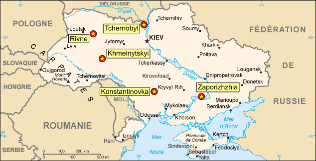
| Description | Map of the Ukrainian nuclear power plants (in French) |
| Date | |
| Source | Background map : Image:Ukraine_carte.png, a modified version of the CIA World Factbook map |
| Author | Eric Gaba (Sting) |
| Permission (Reusing this file) |
Public domain |
Français : * Sujet : Carte en français des centrales nucléaires ukrainiennes ;
- Fond de carte : Image:Ukraine_carte.png, une version modifiée de la carte du CIA World Factbook ;
- Auteur : Eric Gaba (fr:Sting) ;
- Date : Septembre 2006.
Licensing[edit]
| I, the copyright holder of this work, release this work into the public domain. This applies worldwide. In some countries this may not be legally possible; if so: I grant anyone the right to use this work for any purpose, without any conditions, unless such conditions are required by law. |
File history
Click on a date/time to view the file as it appeared at that time.
| Date/Time | Thumbnail | Dimensions | User | Comment | |
|---|---|---|---|---|---|
| current | 20:45, 4 September 2006 | | 634 × 324 (78 KB) | Sting (talk | contribs) | {{Information |Description=Map of the Ukrainian nuclear power plants (in French) |Source=Background map : Image:Ukraine_carte.png, a modified version of the [https://www.cia.gov/cia/publications/factbook/index.html CIA World Factbook] map |Date=Augus |
You cannot overwrite this file.
File usage on Commons
The following page uses this file:
File usage on other wikis
The following other wikis use this file:
- Usage on fr.wikipedia.org
- Usage on ja.wikipedia.org
- Usage on oc.wikipedia.org
- Usage on so.wikipedia.org