File:Geol map.png
Jump to navigation
Jump to search

Size of this preview: 666 × 600 pixels. Other resolutions: 267 × 240 pixels | 533 × 480 pixels | 853 × 768 pixels | 1,137 × 1,024 pixels | 2,275 × 2,048 pixels | 3,000 × 2,701 pixels.
Original file (3,000 × 2,701 pixels, file size: 1.57 MB, MIME type: image/png)
Captions
Captions
Add a one-line explanation of what this file represents
Summary[edit]
| Description |
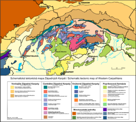
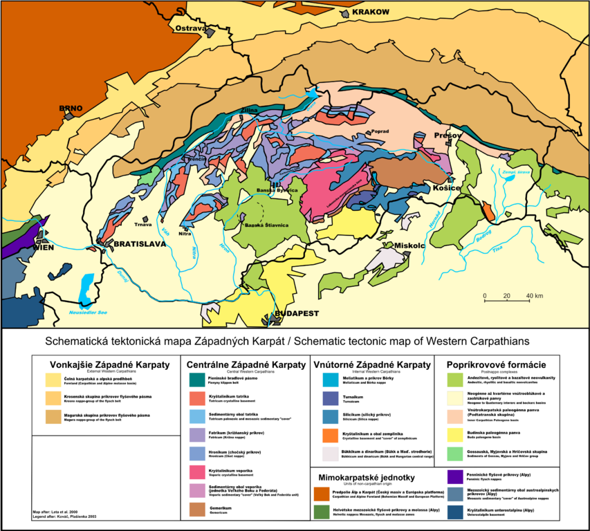
English: Schematic geolgical map of Western Carpathians, with explanation Slovenčina: Schematická geologická mapa Západných Karpát, s vysvetlivkami |
| Date | |
| Source | Own work |
| Author | Pelex |
| Other versions |
 |

|
File:Tect Map West Carp.svg is a vector version of this file. It should be used in place of this PNG file when not inferior.
File:Geol map.png → File:Tect Map West Carp.svg
For more information, see Help:SVG. |
|
Licensing[edit]
I, the copyright holder of this work, hereby publish it under the following licenses:

|
Permission is granted to copy, distribute and/or modify this document under the terms of the GNU Free Documentation License, Version 1.2 or any later version published by the Free Software Foundation; with no Invariant Sections, no Front-Cover Texts, and no Back-Cover Texts. A copy of the license is included in the section entitled GNU Free Documentation License. |
This file is licensed under the Creative Commons Attribution-Share Alike 4.0 International, 3.0 Unported, 2.5 Generic, 2.0 Generic and 1.0 Generic license.
- You are free:
- to share – to copy, distribute and transmit the work
- to remix – to adapt the work
- Under the following conditions:
- attribution – You must give appropriate credit, provide a link to the license, and indicate if changes were made. You may do so in any reasonable manner, but not in any way that suggests the licensor endorses you or your use.
- share alike – If you remix, transform, or build upon the material, you must distribute your contributions under the same or compatible license as the original.
You may select the license of your choice.
File history
Click on a date/time to view the file as it appeared at that time.
| Date/Time | Thumbnail | Dimensions | User | Comment | |
|---|---|---|---|---|---|
| current | 22:16, 15 February 2010 | | 3,000 × 2,701 (1.57 MB) | Pelex (talk | contribs) | without wikipedia logo; fixed spelling mistakes |
| 13:34, 23 May 2009 |  | 3,000 × 2,701 (1.64 MB) | Pelex (talk | contribs) | Update of tectonic division and other minor. | |
| 08:31, 31 December 2008 |  | 3,000 × 2,841 (1.62 MB) | Pelex (talk | contribs) | {{Information |Description= |Source= |Date= |Author= |Permission= |other_versions= }} | |
| 11:43, 6 October 2008 |  | 3,000 × 2,841 (1.62 MB) | Pelex (talk | contribs) | {{Information |Description= |Source= |Date= |Author= |Permission= |other_versions= }} | |
| 18:20, 4 October 2008 |  | 3,167 × 3,000 (1.71 MB) | Pelex (talk | contribs) | {{Information |Description= Schematic geolgical map of Western Carpathians |Source=self-made |Date=October 4 2008 |Author=Pelex |Permission= |other_versions= }} Category:Geology of Slovakia Category:Maps of Slovakia [[Category:Geolo | |
| 11:19, 25 November 2007 |  | 1,600 × 1,279 (572 KB) | Pelex (talk | contribs) | == Opis súboru == {{Information |Description=Schematic geolgical map of Western Carpathians / Schematická geologická mapa Západných Karpát |Source=self-made |Date=18 November 2007, edited 25 November 2007 |Author= Pelex |Permission= | | |
| 16:23, 18 November 2007 |  | 3,200 × 2,559 (1.2 MB) | Pelex (talk | contribs) | {{Information |Description=Schematic geolgical map of Western Carpathians |Source=self-made |Date=18 November 2007 |Author= Pelex |Permission= |other_versions= }} Category:Geology of Slovakia |
You cannot overwrite this file.
File usage on Commons
The following 2 pages use this file:
File usage on other wikis
The following other wikis use this file:
- Usage on be.wikipedia.org
- Usage on bg.wikipedia.org
- Usage on cs.wikipedia.org
- Geografie Slovenska
- Geologie Západních Karpat
- Bradlové pásmo
- Silicikum
- Wikipedie:WikiProjekt Česko-slovenská Wikipedie/Přeložené články/2014-01/Galerie
- Gemerikum
- Subtatranské příkrovy
- Tatrikum
- Turnaikum
- Veporikum
- Štiavnický stratovulkán
- Meliatikum
- Příkrov Bôrky
- Čertovická linie
- Fatrikum
- Peripieninský lineament
- Váhikum
- Transdanubikum
- Oravikum
- Czorsztynská elevace
- Bükkikum
- Zemplinikum
- Lubenicko-margecanská linie
- Usage on de.wikipedia.org
- Usage on el.wikipedia.org
- Usage on en.wikipedia.org
- Usage on es.wikipedia.org
- Usage on hr.wikipedia.org
- Usage on mk.wikipedia.org
- Usage on pl.wikipedia.org
- Usage on sh.wikipedia.org
- Usage on sk.wikipedia.org
View more global usage of this file.