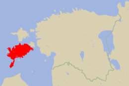
Saaremaa: Island in Estonia
Saaremaa is the largest island in Estonia.
It is 2,673 km2 (1,032 sq mi). The island is in the Baltic Sea, south of Hiiumaa island and west of Muhu island. It belongs to the West Estonian Archipelago.
 Location of Saaremaa in Estonia | |
Location in the Baltic Sea region | |
| Geography | |
|---|---|
| Location | Baltic Sea |
| Coordinates | 58°25′N 22°30′E / 58.417°N 22.500°E |
| Archipelago | West Estonian archipelago |
| Area | 2,673 km2 (1,032 sq mi) |
| Administration | |
| County | Saare County |
| Demographics | |
| Population | 31,357 (31 January 2017) |
| Pop. density | 11.7/km2 (30.3/sq mi) |
The highest point on Saaremaa is 54 m above sea level. One feature found on the island is the Kaali crater. The island has lots of forested land. One of the symbols of the island is the juniper.
References

This article uses material from the Wikipedia Simple English article Saaremaa, which is released under the Creative Commons Attribution-ShareAlike 3.0 license ("CC BY-SA 3.0"); additional terms may apply (view authors). Content is available under CC BY-SA 4.0 unless otherwise noted. Images, videos and audio are available under their respective licenses.
®Wikipedia is a registered trademark of the Wiki Foundation, Inc. Wiki Simple English (DUHOCTRUNGQUOC.VN) is an independent company and has no affiliation with Wiki Foundation.
