Petah Tikva: City in Israel
Petah Tikva (Hebrew: פתח תקווה, Arabic: بتاح تكفا , meaning opening of hope; other spellings: Petah Tiqwa (official) and Petach Tikvah (unofficial)) is a city in western Israel.
is a city in the Central District of Israel. It is 11 kilometres (6.8 miles) east from Tel Aviv and belongs to the Tel Aviv Metropolitan Area. About 231,000 people were living there in 2015, making it the fifth-largest city of the country. About 70,000 of them are Orthodox Jews.
Petah Tikva פתח תקווה بتاح تكفا | |
|---|---|
City | |
 Koblenz Square | |
 Coat of arms | |
| Nickname: Em HaMoshavot | |
 Petah Tikva Location in Israel | |
| Coordinates: 32°05′19.78″N 34°53′10.8″E / 32.0888278°N 34.886333°E | |
| Country | Israel |
| District | Central District |
| Founded | 1878 |
| Government | |
| • Mayor | Zvi Lustig |
| Area | |
| • Total | 35.868 km2 (13.849 sq mi) |
| Elevation | 15 m (49 ft) |
| Population (2015) | |
| • Total | 230,984 |
| • Density | 6,440/km2 (16,700/sq mi) |
| Time zone | UTC+2 (Israel Standard Time (IST)) |
| • Summer (DST) | UTC+3 (Israel Summer Time (IDT)) |
| Area code | +972 (Israel) +3 (Central District) |
| Website | Petah Tikva Website |
European Orthodox Jews established the settlement in 1878 and named it Petah Tikva after a prophecy of Hosea. Because of this, it is the oldest agricultural settlement erected by Zionist Jews in the 19th century and therefore nicknamed Em HaMoshavot, meaning mother of the moshavot. The new settlement was attacked by raiders in 1886, a few guards volunteered to keep it safe from raiders, in total the settlement had six guards, the last and most famous out of them is Avraham Shapira, his original house stand til this day intact. It obtained city status in 1937.
The city is low-lying. The Yarkon River flows north of Petah Tikva.
Petah Tikva comes second in a list of cities in Israel industrial activities. Many high-tech and communications companies have their headquarters here. The city used to be surrounded by a lot of citrus plantations but due to urban expansion this is no longer the case.
The city has about 300 synagogues, the same number of educational institutions, and six hospitals, among them the Rabin Medical Center.
Several highways are close by, like Highway 4 in the west, Trans-Samaria Highway in the north, and Trans-Israel Highway in the east.
Yarkon Cemetery is in Petah Tikva and is the most important cemetery of the Tel Aviv Metropolitan Area.
Well-known people
- Gal Gadot (b. 1985), actress and model
- Amnon Krauz (b. 1952), swimmer
- Uri Orbach (1960-2015), children's writer, journalist and politician
- Pnina Rosenblum (b. 1954), business woman and politician
- Mordechai Tzipori (1924-2017), general and politician
-
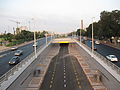 Bus-only lane in Petah Tikva
 -
 The Great Synagogue
 -
 Azorim high-tech park
 -
 Petah Tikva during the 1920s
 -
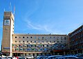 Municipality building of Petah Tikva
 -
 A part of the city


Other websites
![]() Media related to Petah Tikva at Wiki Commons
Media related to Petah Tikva at Wiki Commons

 This short article about a place or feature can be made longer. You can help Wikipedia by adding to it.
This article uses material from the Wikipedia Simple English article Petah Tikva, which is released under the Creative Commons Attribution-ShareAlike 3.0 license ("CC BY-SA 3.0"); additional terms may apply (view authors). Content is available under CC BY-SA 4.0 unless otherwise noted. Images, videos and audio are available under their respective licenses.
®Wikipedia is a registered trademark of the Wiki Foundation, Inc. Wiki Simple English (DUHOCTRUNGQUOC.VN) is an independent company and has no affiliation with Wiki Foundation.