Loiret: French department
Loiret is a department in north-central France in the Centre-Val de Loire region.
It is named after the Loiret river, a tributary of Loire that is completely within the department.
Loiret | |
|---|---|
.jpg) Prefecture building of the Loiret department, in Orléans. | |
 Flag  Coat of arms | |
 Location of Loiret in France | |
| Coordinates: 47°55′N 02°10′E / 47.917°N 2.167°E | |
| Country | France |
| Region | Centre-Val de Loire |
| Département | 4 March 1790 |
| Prefecture | Orléans |
| Subprefectures | Montargis, Pithiviers |
| Government | |
| • President | Hugues Saury |
| Area | |
| • Total | 6,775.2 km2 (2,615.9 sq mi) |
| Population (2014) | |
| • Total | 669,737 |
| • Density | 99/km2 (260/sq mi) |
| Demonym | Loiretains |
| Time zone | UTC+1 (CET) |
| • Summer (DST) | UTC+2 (CEST) |
| ISO 3166 code | FR-45 |
| Arrondissements | 3 |
| Cantons | 21 |
| Communes | 326 |
| Website | Official website |
Its prefecture is Orléans and there are two subprefectures: Montargis and Pithiviers.
History
The department is one of the 83 French departments made during the French revolution, on 4 March 1790. The department was created from part of the former province of Orléanais.
The new department had seven districts: Orléans, Beaugency, Neuville, Pithiviers, Montargis, Gien and Boiscommun. The capital (now prefecture) was Orléans.
In 1800, with the creation of the arrondissements in France, the seven districts were changed into four arrondissements: Orléans, Gien, Montargis and Pithiviers.
After the Battle of Waterloo (18 June 1815), the department was occupied by the Bavarian army from June 1815 to November 1818.
On 10 September 1926, the arrondissement of Gien and Pithiviers were eliminated but in 1942 Pithiviers became again an arrondissement of the department.
Geography
Loiret is part of the Centre-Val de Loire region. It has an area of 6,775.2 km2 (2,616 sq mi).
The department is bordered by the 7 departments in 3 regions:
- Centre-Val de Loire region
- Île-de-France region
- Bourgogne-Franche-Comté region
The highest point of the department is in the place called Col des Étourneaux (47°32′0″N 2°41′49″E / 47.53333°N 2.69694°E), in the commune of Pierrefitte-ès-Bois, and that is 273 m (896 ft) above sea level; it is in northwestern Massif Central.
The main rivers are:
- Loire, that flows through the department from the southeast to the west.
- Loiret, a short tributary of the Loire and that gives its name to the department.
- Loing, 142 km long.
- Cosson, 96.4 km long.
- Essonne, 97 km long.
There are several natural regions in the Loiret department:
- The Loire Valley, the valley around the Loire river.
- Beauce, to the northwest of the department; it is a limestone plateau and an important farming region where wheat is grown.
- Gâtinais, to the east around the city of Montargis.
- The Forêt d'Orléans ("Forest of Orléans"), the largest national forest of France; it is to the north of the Loire river and to the south of the Beauce region.
- Sologne, south of the Loire river.
- Berry (a small part), to the southeast.
- Puisaye, between the Berry and the Gâtinais.
Climate
The Köppen climate classification type for the climate at Orléans is an "Oceanic climate" (also known as Marine West Coast Climate) and of the subtype Cfb.
The average amount of precipitation for the year in Orléans is 599.4 mm (23.6 in). The month with the most precipitation on average is August with 58.4 mm (2.3 in) of precipitation. The month with the least precipitation on average is March with an average of 38.1 mm (1.5 in).
The average temperature for the year in Orléans is 10.6 °C (51.1 °F). The warmest month, on average, is July with an average temperature of 18.3 °C (64.9 °F). The coolest month on average is January, with an average temperature of 2.8 °C (37.0 °F).
Administration
The department is managed by the Departmental Council of the Loiret in Orléans. Loiret is part of the region of Centre-Val de Loire.
Administrative divisions
There are 3 arrondissements (districts), 21 cantons and 326 communes (municipalities) in Loiret.
| INSEE code | Arrondissement | Capital | Population (2014) | Area (km²) | Density (Inh./km²) | Communes |
|---|---|---|---|---|---|---|
| 451 | Montargis | Montargis | 170,781 | 2,631.3 | 64.9 | 126 |
| 452 | Orléans | Orléans | 435,676 | 2,945.8 | 147.9 | 121 |
| 453 | Pithiviers | Pithiviers | 63,280 | 1,198.1 | 52.8 | 79 |
The following is a list of the 21 cantons of the Loir-et-Cher department, following the French canton reorganisation which came into effect in March 2015:
- Beaugency (4501)
- Châlette-sur-Loing (4502)
- Châteauneuf-sur-Loire (4503)
- Courtenay (4504)
- La Ferté-Saint-Aubin (4505)
- Fleury-les-Aubrais (4506)
- Gien (4507)
- Lorris (4508)
- Malesherbes (4509)
- Meung-sur-Loire (4510)
- Montargis (4511)
- Olivet (4512)
- Orléans-1 (4513)
- Orléans-2 (4514)
- Orléans-3 (4515)
- Orléans-4 (4516)
- Pithiviers (4517)
- Saint-Jean-de-Braye (4518)
- Saint-Jean-de-la-Ruelle (4519)
- Saint-Jean-le-Blanc (4520)
- Sully-sur-Loire (4521)
Demographics
The inhabitants of Loiret are known, in French, as Loiretains (women: Loiretaines).
Loiret has a population, in 2014, of 669,737, for a population density of 98.9 inhabitants/km2. The arrondissement of Orléans, with 435,676 inhabitants, is by far the largest.
Evolution of the population in Loiret

The main cities in the department are:
| City | Population (2014) | Arrondissement |
|---|---|---|
| Orléans | 114,977 | Orléans |
| Olivet | 21,192 | Orléans |
| Fleury-les-Aubrais | 20,791 | Orléans |
| Saint-Jean-de-Braye | 19,804 | Orléans |
| Saint-Jean-de-la-Ruelle | 16,415 | Orléans |
| Saran | 15,686 | Orléans |
| Gien | 14,617 | Montargis |
| Montargis | 13,997 | Montargis |
| Amilly | 12,672 | Montargis |
| Châlette-sur-Loing | 12,643 | Montargis |
| La Chapelle-Saint-Mesmin | 10,117 | Orléans |
Gallery
-

-
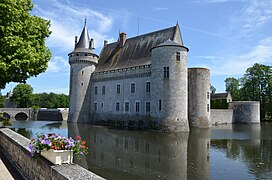 Château de Sully-sur-Loire
 -
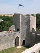 Yèvre-le-Châtel
 -
 Beaugency
 -
 Meung-sur-Loire
 -


References
Related pages
Other websites
- Departmental Council website (in French)
- Prefecture website (in French)
This article uses material from the Wikipedia Simple English article Loiret, which is released under the Creative Commons Attribution-ShareAlike 3.0 license ("CC BY-SA 3.0"); additional terms may apply (view authors). Content is available under CC BY-SA 4.0 unless otherwise noted. Images, videos and audio are available under their respective licenses.
®Wikipedia is a registered trademark of the Wiki Foundation, Inc. Wiki Simple English (DUHOCTRUNGQUOC.VN) is an independent company and has no affiliation with Wiki Foundation.