Karnali Province: Province of Nepal
Karnali Province (Nepali: कर्णाली प्रदेश) is one of the seven federal provinces of Nepal.
The total area of the province is 27,984 square kilometres (10,805 sq mi). According to the 2011 Nepal census, the population of the province was 1,570,418.
Karnali Pradesh कर्णाली प्रदेश | |
|---|---|
 Location of Karnali Pradesh | |
 Districts of Karnali Pradesh | |
| Country | |
| Formation | 20 September 2015 |
| Capital | Birendranagar |
| Largest city | Birendranagar |
| Districts | 10 |
| Government | |
| • Body | Government of Karnali Pradesh |
| • Governor | Tilak Pariyar |
| • Chief Minister | Mahendra Bahadur Shahi (NCP) |
| • High Court | Surkhet High Court |
| • Provincial Assembly | Unicameral (40 seats) |
| • Parliamentary constituency | 12 |
| Area | |
| • Total | 27,984 km2 (10,805 sq mi) |
| • Rank | 1st |
| Population (2011) | |
| • Total | 1,570,418 |
| • Rank | 7th |
| • Density | 56/km2 (150/sq mi) |
| • Rank | 7th |
| Demonym | Karnali/Karnalese |
| Time zone | UTC+5:45 (NST) |
| Geocode | NP-SI |
| Main Official Language | Nepali (96.47%) |
| Other Official Language(s) | 1. Magar (1.1%) 2. Tamang (0.9%) |
| HDI | 0.469 (low) |
| Literacy | 62.77% |
| Sex ratio | 95.78 ♂ /100 ♀ (2011) |
| Website | www.karnali.gov.np |
At first it was known as Province No. 6. The Provincial Assembly named this province Karnali Pradesh in February 2018. It borders the Tibet Autonomous Region of China to the north, Gandaki Province to the east, Sudurpashchim Province to the west, and Lumbini Province to the south. Birendranagar is the capital city of the province.
Geography
Karnali is the largest province of Nepal. It has an area of 24,453 km2 (9,441 sq mi) but the population of the province is very low. The population of the province is 1,701,800, which is least in ranking.
The province is surrounded by Gandaki Province in east, Lumbini Province in south-east and south, Sudurpashchim Province in west and Tibet Autonomous Region of China in north.
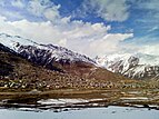
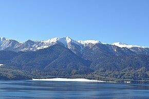
The province has occupied higher mountains land of north and mid-hills of Nepal. It contains Kubi Gangri, Changla and Kanjiroba mountains in north. The Shey Phoksundo National Park with Phoksundo lake is located in this national park. It is the largest national park in Nepal. The Rara lake is the largest lake of Nepal which is also located in Karnali Pradesh. Karnali River is the biggest river of the province which is thought to be the longest river of Nepal. Seti River and Bheri River are tributaries of Karnali.
Government and administration
The Governor acts as the head of the province. The current Governor is Durga Keshar Khanal. The Chief Minister is the head of the provincial government. The current Chief Minister is Mahendra Bahadur Shahi. The Chief Judge of the Surkhet High Court is the head of the judiciary. The current Chief Judge is Hari Kumar Pokharel. The province has 40 provincial assembly constituencies and 12 House of Representative constituencies.
Karnali has a unicameral legislature, like all of the other provinces in Nepal. The term length of provincial assembly is five years.
Administrative subdivisions
Karnali is divided into ten districts, which are listed below. A district is administrated by the head of the District Coordination Committee and the District Administration Officer. The districts are further dived to municipalities or rural municipalities. There are 25 municipalities and 54 rural municipalities in the province
- Dailekh District
- Dolpa District
- Humla District
- Jajarkot District
- Jumla District
- Kalikot District
- Mugu District
- Salyan District
- Surkhet District
- Western Rukum District
Related pages
References
29°30′N 82°25′E / 29.500°N 82.417°E
This article uses material from the Wikipedia Simple English article Karnali Province, which is released under the Creative Commons Attribution-ShareAlike 3.0 license ("CC BY-SA 3.0"); additional terms may apply (view authors). Content is available under CC BY-SA 4.0 unless otherwise noted. Images, videos and audio are available under their respective licenses.
®Wikipedia is a registered trademark of the Wiki Foundation, Inc. Wiki Simple English (DUHOCTRUNGQUOC.VN) is an independent company and has no affiliation with Wiki Foundation.


