Indianola, Oklahoma: Town in Oklahoma, United States
Indianola is a town in the U.S.
state">U.S. state of Oklahoma.
Indianola, Oklahoma | |
|---|---|
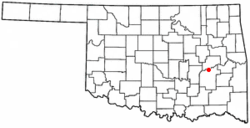
 Location of Indianola, Oklahoma | |
| Coordinates: 35°09′48″N 95°46′33″W / 35.16333°N 95.77583°W | |
| Country | United States |
| State | Oklahoma |
| County | Pittsburg |
| Area | |
| • Total | 0.32 sq mi (0.83 km2) |
| • Land | 0.32 sq mi (0.83 km2) |
| • Water | 0.00 sq mi (0.00 km2) |
| Elevation | 663 ft (202 m) |
| Population (2020) | |
| • Total | 148 |
| • Density | 463.95/sq mi (178.92/km2) |
| Time zone | UTC-6 (Central (CST)) |
| • Summer (DST) | UTC-5 (CDT) |
| ZIP code | 74442 |
| Area code(s) | 539/918 |
| FIPS code | 40-36950 |
| GNIS feature ID | 2412793 |
References
This article uses material from the Wikipedia Simple English article Indianola, Oklahoma, which is released under the Creative Commons Attribution-ShareAlike 3.0 license ("CC BY-SA 3.0"); additional terms may apply (view authors). Content is available under CC BY-SA 4.0 unless otherwise noted. Images, videos and audio are available under their respective licenses.
®Wikipedia is a registered trademark of the Wiki Foundation, Inc. Wiki Simple English (DUHOCTRUNGQUOC.VN) is an independent company and has no affiliation with Wiki Foundation.
