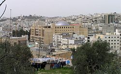
Hebron: City in the West Bank, State of Palestine
Hebron is a Palestinian city 30 km (19 mi) south of Jerusalem.
It is in the Judaean Mountains, 930 meters (3,050 ft) above sea level. It is the largest city in the West Bank, and the second largest in the Palestinian territories after Gaza. There are about 215,000 people living in Hebron (2016).
Hebron | |
|---|---|
 Downtown Hebron | |
| Nickname: City of the Patriarchs | |
| Coordinates: 31°32′0″N 35°5′42″E / 31.53333°N 35.09500°E | |
| Population (2016) | |
| • Total | 215,452 |
| Website | www.hebron-city.ps |
Hebron is divided into two parts: H1, controlled by the Palestinian National Authority, and H2, about 20% of the city, controlled by Israel.
The city is famous as the traditional burial site of the Biblical Patriarchs and Matriarchs. This makes it a very important city in Judaism. It is also very important to Muslims because of its connections with Abraham.
Hebron is important to the economy of the area due to the sale of marble from quarries. It is known for its grapes, figs, limestone, pottery workshops and glassblowing factories. It is also the location of the major dairy-product maker, al-Junaidi. The old city of Hebron has narrow, winding streets, flat-roofed stone houses, and old bazaars. The city is home to Hebron University and the Palestine Polytechnic University. It has no cinemas or places of entertainment.
Gallery
- Tel Rumeida (Old Hebron)
References
Other websites

- www.hebron-city.ps
- Hebron Chamber of Commerce Archived 2008-08-20 at the Wayback Machine
- Israeli Ministry of Foreign affairs
- Photographs of Hebron
- RamallahOnline - Photos of Hebron
- Hebron.com - English
- Collection of Palestinian articles on Hebron published by "This Week in Palestine"
- Sephardic Studies 1839 Sephardic census of Ottoman-controlled Hebron.
- ArchNet.org. "Hebron". Cambridge, Massachusetts, USA: MIT School of Architecture and Planning. Archived from the original on 2014-01-05. Retrieved 2016-06-19.
- Settlement Encroachments in Hebron Old City. Photo's/maps of settlements and closed roads. Hebron Rehabilitation Committee, 1 April 2014.
- Settlements on GoogleMaps
This article uses material from the Wikipedia Simple English article Hebron, which is released under the Creative Commons Attribution-ShareAlike 3.0 license ("CC BY-SA 3.0"); additional terms may apply (view authors). Content is available under CC BY-SA 4.0 unless otherwise noted. Images, videos and audio are available under their respective licenses.
®Wikipedia is a registered trademark of the Wiki Foundation, Inc. Wiki Simple English (DUHOCTRUNGQUOC.VN) is an independent company and has no affiliation with Wiki Foundation.


