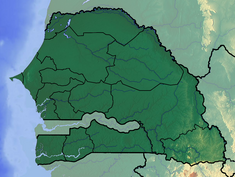
Diama Dam: Dam between Senegal and Mauritania
The Diama Dam, sometimes called the Maka–Diama Dam (French: Barrage de Maka-Diama) is a gravity dam on the Senegal River.
This article may have too many red links. (September 2023) |
It goes across the border of Senegal and Mauritania. It is next to the town of Diama, Senegal. It is about 22 km (14 mi) north of Saint-Louis, Senegal. The dam was built to stop saltwater intrusion upstream, supply water for the irrigation of about 45,000 ha (110,000 acres) of crops, and create a road crossing for the road between St. Louis and Nouakchott in Mauritania. Additionally, a ship lock built in the dam allows navigation upstream. Plans for the dam were first made in 1970 when the riparian states in the Senegal River Basin Development Authority agreed to develop the Senegal River. The Diama Dam was to be built along with the Manantali Dam which was to be in Mali. Construction on the Diama Dam began on 15 September 1981 and was completed on 12 August 1986. The Manantali Dam was completed in 1988. The Diama project was funded by a US$149.5 million loan from the African Development Bank. The main section of the dam with the ship lock and spillway is 170 m (560 ft) long while a 440 m (1,440 ft) long embankment dam section goes north to the edge of the river. A dike makes the dam go even further north. The dam is 18 m (59 ft) tall and its spillway has a maximum discharge of 6,500 m3/s (230,000 cu ft/s).
| Diama Dam | |
|---|---|
 Ship lock on the dam | |
| Official name | Barrage de Diama |
| Country | Senegal/Mauritania |
| Location | Diama-Maka |
| Coordinates | 16°13′0.20″N 16°24′53.63″W / 16.2167222°N 16.4148972°W |
| Purpose | Navigation, water quality, irrigation |
| Status | Operational |
| Construction began | 1981 |
| Opening date | 1986 |
| Construction cost | US$149.5 million |
| Dam and spillways | |
| Type of dam | Gravity |
| Impounds | Senegal River |
| Height | 18 m (59 ft) |
| Length | 610 m (2,000 ft) |
| Spillway capacity | 6,500 m3/s (230,000 cu ft/s) |
| Reservoir | |
| Total capacity | 250,000,000 m3 (200,000 acre⋅ft) |
| Surface area | 235 km2 (91 sq mi) |
The small town of Diama is known as a border crossing to and from Mauritania. This is because the dam is the only land bridge between the two countries.
References
This article uses material from the Wikipedia Simple English article Diama Dam, which is released under the Creative Commons Attribution-ShareAlike 3.0 license ("CC BY-SA 3.0"); additional terms may apply (view authors). Content is available under CC BY-SA 4.0 unless otherwise noted. Images, videos and audio are available under their respective licenses.
®Wikipedia is a registered trademark of the Wiki Foundation, Inc. Wiki Simple English (DUHOCTRUNGQUOC.VN) is an independent company and has no affiliation with Wiki Foundation.

