File:South Africa extremes.jpg
Jump to navigation
Jump to search

Size of this preview: 454 × 600 pixels. Other resolutions: 182 × 240 pixels | 580 × 766 pixels.
Original file (580 × 766 pixels, file size: 245 KB, MIME type: image/jpeg)
Captions
Captions
Add a one-line explanation of what this file represents
Summary[edit]
| Description |
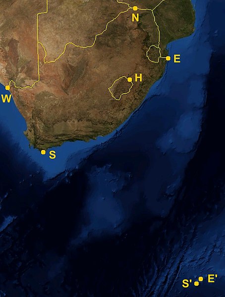
Satellite picture of South Africa, showing its extreme points. Legend:
|
| Date | |
| Source | Satellite imagery and country borders from NASA World Wind |
| Author | Júlio Reis |
Licensing[edit]
This file is licensed under the Creative Commons Attribution-Share Alike 3.0 Unported license.
- You are free:
- to share – to copy, distribute and transmit the work
- to remix – to adapt the work
- Under the following conditions:
- attribution – You must give appropriate credit, provide a link to the license, and indicate if changes were made. You may do so in any reasonable manner, but not in any way that suggests the licensor endorses you or your use.
- share alike – If you remix, transform, or build upon the material, you must distribute your contributions under the same or compatible license as the original.
File history
Click on a date/time to view the file as it appeared at that time.
| Date/Time | Thumbnail | Dimensions | User | Comment | |
|---|---|---|---|---|---|
| current | 16:51, 24 June 2006 | | 580 × 766 (245 KB) | Tintazul (talk | contribs) | {{Tintazul| |Description=Satellite picture of South Africa, showing its extreme points. Legend: * '''N''' Northern: Beit Bridge, Limpopo * '''S'''' Southern: Marion Island, Prince Edward Islands, Western Cape * '''S''' Southern (continental): Cape Agulhas |
You cannot overwrite this file.
File usage on Commons
The following page uses this file:
File usage on other wikis
The following other wikis use this file:
- Usage on af.wikipedia.org
- Usage on fr.wikipedia.org
- Usage on sh.wikipedia.org
- Usage on sr.wikipedia.org