File:Podjela Kraljevine SHS na 33 oblasti.jpg
Jump to navigation
Jump to search
Size of this preview: 717 × 599 pixels. Other resolutions: 287 × 240 pixels | 574 × 480 pixels | 1,000 × 836 pixels.
Original file (1,000 × 836 pixels, file size: 215 KB, MIME type: image/jpeg)
Captions
Captions
Add a one-line explanation of what this file represents

|
This locator map image could be re-created using vector graphics as an SVG file. This has several advantages; see Commons:Media for cleanup for more information. If an SVG form of this image is available, please upload it and afterwards replace this template with
{{vector version available|new image name}}.
It is recommended to name the SVG file “Podjela Kraljevine SHS na 33 oblasti.svg”—then the template Vector version available (or Vva) does not need the new image name parameter. |


Summary[edit]
| Description |
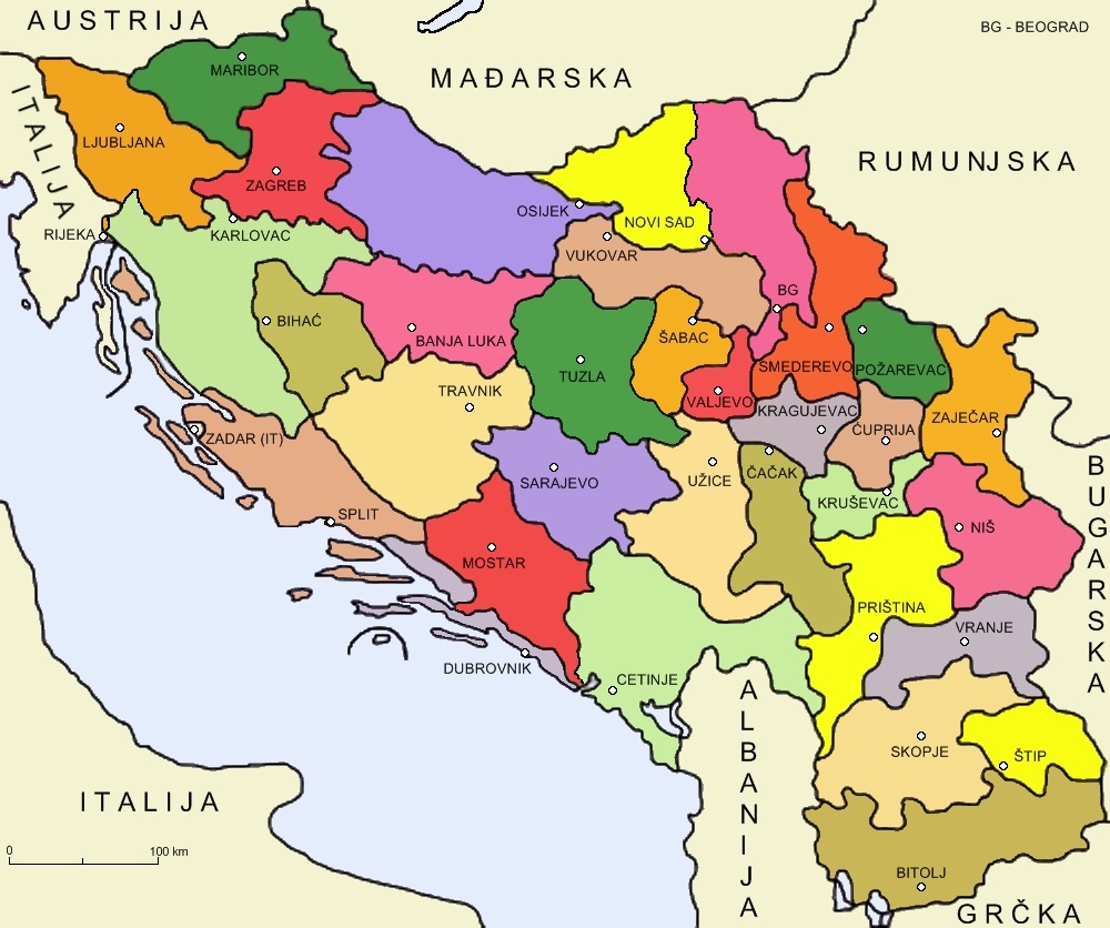
English: Administrative division of Kingdom of Serbs, Croats and Slovenes on 33 oblasts from 1922 to 1929.
Hrvatski: Upravno-teritorijalna podjela Kraljevine Srba, Hrvata i Slovenaca na 33 oblasti od 1922. do 1929. |
| Date | |
| Source | Own work |
| Author | Bijela zastava |
| Other versions | Derivative works of this file: Podjela Kraljevine SHS na 33 oblasti prazna.jpg |
Licensing[edit]
I, the copyright holder of this work, hereby publish it under the following license:
This file is licensed under the Creative Commons Attribution 3.0 Unported license.
- You are free:
- to share – to copy, distribute and transmit the work
- to remix – to adapt the work
- Under the following conditions:
- attribution – You must give appropriate credit, provide a link to the license, and indicate if changes were made. You may do so in any reasonable manner, but not in any way that suggests the licensor endorses you or your use.
File history
Click on a date/time to view the file as it appeared at that time.
| Date/Time | Thumbnail | Dimensions | User | Comment | |
|---|---|---|---|---|---|
| current | 08:55, 29 September 2023 | | 1,000 × 836 (215 KB) | Ceha (talk | contribs) | Ispravio neke greške, Kastav, Čabar, Sutorina, istočna Bačka |
| 01:09, 19 June 2010 |  | 1,000 × 836 (405 KB) | Bijela zastava (talk | contribs) | {{Information |Description={{en|1=Administrative division of Kingdom of Serbs, Croats and Slovenes on 33 oblasts from 1922 to 1929.}} {{hr|1=Upravno-teritorijalna podjela Kraljevine Srba, Hrvata i Slovenaca na 33 oblasti od 1922. do 1929.}} |Source={{own} |
You cannot overwrite this file.
File usage on Commons
The following page uses this file:
File usage on other wikis
The following other wikis use this file:
- Usage on en.wikipedia.org
- Usage on hr.wikipedia.org
- Usage on it.wikipedia.org
- Usage on pl.wikipedia.org
- Usage on pt.wikipedia.org
- Usage on ro.wikipedia.org
- Usage on sh.wikipedia.org
- Usage on tr.wikipedia.org
- Usage on uk.wikipedia.org