File:IranOMC.png
Jump to navigation
Jump to search
Size of this preview: 708 × 600 pixels. Other resolutions: 283 × 240 pixels | 567 × 480 pixels | 930 × 788 pixels.
Original file (930 × 788 pixels, file size: 53 KB, MIME type: image/png)
Captions
Captions
Add a one-line explanation of what this file represents
Summary[edit]
| Description |
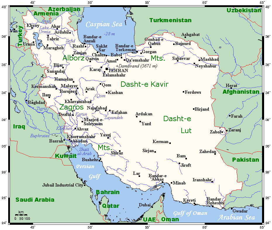
English: A map showing Iran's cities and main towns. This map's source is here, with the uploader's modifications, and the GMT homepage says that the tools are released under the GNU General Public License. |
| Date | 6 August 2007 (original upload date) |
| Source | Transferred from en.wikipedia to Commons. |
| Author | Kelisi at English Wikipedia |
Licensing[edit]
Kelisi at the English-language Wikipedia, the copyright holder of this work, hereby publishes it under the following license:
| This file is licensed under the Creative Commons Attribution-Share Alike 3.0 Unported license. Subject to disclaimers. | ||
| Attribution: Kelisi at the English-language Wikipedia | ||
| ||
| This licensing tag was added to this file as part of the GFDL licensing update. |

|
Permission is granted to copy, distribute and/or modify this document under the terms of the GNU Free Documentation License, Version 1.2 or any later version published by the Free Software Foundation; with no Invariant Sections, no Front-Cover Texts, and no Back-Cover Texts. A copy of the license is included in the section entitled GNU Free Documentation License. Subject to disclaimers. |
Original upload log[edit]
The original description page was here. All following user names refer to en.wikipedia.
- 2007-08-06 16:05 Kelisi 930×788× (54211 bytes) == Summary == A map showing Iran's cities and main towns. This map's source is [http://www.aquarius.ifm-geomar.de/ here], with the uploader's modifications, and the [http://gmt.soest.hawaii.edu/ GMT homepage] says that the tools are released under the GNU
File history
Click on a date/time to view the file as it appeared at that time.
| Date/Time | Thumbnail | Dimensions | User | Comment | |
|---|---|---|---|---|---|
| current | 05:59, 27 November 2011 | | 930 × 788 (53 KB) | Urdangaray (talk | contribs) | {{Information |Description={{en|A map showing Iran's cities and main towns. This map's source is [http://www.aquarius.ifm-geomar.de/ here], with the uploader's modifications, and the [http://gmt.soest.hawaii.edu/ GMT homepage] says that the tools are rele |
You cannot overwrite this file.
File usage on Commons
There are no pages that use this file.
File usage on other wikis
The following other wikis use this file:
- Usage on ast.wikipedia.org
- Usage on en.wikipedia.org
- Usage on es.wikipedia.org
- Usage on eu.wikipedia.org
- Usage on fa.wikipedia.org
- Usage on fr.wikipedia.org
- Usage on hi.wikipedia.org
- Usage on id.wikipedia.org
- Usage on mg.wikipedia.org
- Usage on ms.wikipedia.org
- Usage on my.wikipedia.org
- Usage on nn.wikipedia.org
- Usage on se.wikipedia.org
- Usage on sl.wikipedia.org
- Usage on smn.wikipedia.org
- Usage on tg.wikipedia.org
- Usage on uk.wikipedia.org
- Usage on zh.wikipedia.org