Eritrea
39°E / 15°N 39°E / 15; 39
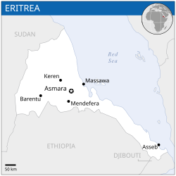
Eritrea (pronounced /ˌɛrɨˈtreɪ.ə/ (deprecatit template) or /ˌɛrɨˈtriːə/; Ge'ez: ኤርትራ ʾErtrā, Arabic: إرتريا Iritrīyā), offeecially the State o Eritrea, is a kintra in the North East o Africae. The caipital is Asmara. It is bordered bi Sudan in the wast, Ethiopie in the sooth, an Djibouti in the sootheast. The east an northeast o the kintra hae an extensive coastline on the Red Sea, directly athort frae Saudi Arabie an Yemen. The Dahlak Archipelago an several o the Hanish Islands are pairt o Eritrea. Eritrea's size is approximately 117,600 km2 wi an estimatit population o 5 million.
State o Eritrea | |
|---|---|
 Location o Eritrea (daurk green) – in Africae (daurk grey) | |
 | |
| Caipital | Asmara 15°20′N 38°55′E / 15.333°N 38.917°E |
| Lairgest ceety | capital |
| Offeecial leids | None (see wirkin leids) |
| Recognised naitional leids | |
| Wirkin leids | |
| Ethnic groups (2012) |
|
| Demonym(s) | Eritrean |
| Govrenment | Unitar ane-pairty presidential republic |
• Preses | Isaias Afwerki |
| Legislatur | Naitional Assembly |
| Formation | |
• Dʿmt | c. 980 AC |
• Kinrick o Aksum | c. 100 AD |
• Medri Bahri | 1137 |
• Italian Eritrea | 1890 |
• Eritrean Federation | 15 September 1952 |
• De facto State o Eritrea | 24 Mey 1991 |
• De jure State o Eritrea | 24 Mey 1993 |
| Aurie | |
• Total | 117,600 km2 (45,400 sq mi) (101st) |
• Water (%) | 0.14% |
| Population | |
• 2016 estimate | 5,869,869 (116t) |
• Density | 51.8/km2 (134.2/sq mi) (154t) |
| GDP (PPP) | 2017 estimate |
• Total | $9.671 billion |
• Per capita | $1,349 |
| GDP (nominal) | 2017 estimate |
• Tot | $6.050 billion |
• Per capita | $844 |
| HDI (2015) | law · 179th |
| Currency | Nakfa (ERN) |
| Time zone | UTC+3 (EAT) |
• Summer (DST) | UTC+3 (nae observed) |
| Drivin side | richt |
| Cawin code | +291 |
| ISO 3166 code | ER |
| Internet TLD | .er |


References
| Wiki Commons haes media relatit tae Eritrea. |
This article uses material from the Wikipedia Scots article Eritrea, which is released under the Creative Commons Attribution-ShareAlike 3.0 license ("CC BY-SA 3.0"); additional terms may apply (view authors). Content is available unner CC BY-SA 4.0 unless itherwise notit. Images, videos and audio are available under their respective licenses.
®Wikipedia is a registered trademark of the Wiki Foundation, Inc. Wiki Scots (DUHOCTRUNGQUOC.VN) is an independent company and has no affiliation with Wiki Foundation.

