File:1700 CE world map.PNG
Jump to navigation
Jump to search

Size of this preview: 800 × 397 pixels. Other resolutions: 320 × 159 pixels | 640 × 318 pixels | 1,024 × 508 pixels | 1,280 × 635 pixels | 2,560 × 1,271 pixels | 4,500 × 2,234 pixels.
Original file (4,500 × 2,234 pixels, file size: 364 KB, MIME type: image/png)
Captions
Captions
Add a one-line explanation of what this file represents
Summary[edit]
| Description |
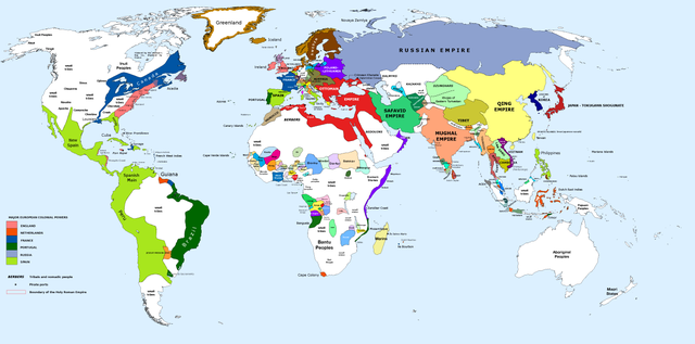
English: 1700 AD: An illustrative map of the world in the early colonial period. The Mughal Empire in India is at its greatest territorial extent. |
||
| Date | |||
| Source | Own work. Blank map from File:World_Map_Blank.svg. | ||
| Author | Urnanabha | ||
| Other versions |
|

| Maps of world history | |
| BC | |
|
| |
| AD |
1 · 50 · 100 · 200 · 250 · 300 · 400 · 500 · 700 · 750 · 820 · 900 · 1200 · 1500 · 1556 · 1648 · 1700 · 1750 · 1815 · 1859 · 1871 · 1914 · 1935 · 1954 · 1989 · 2000 · |
|
Maps of colonization history | |
|
see also: Eastern Hemisphere only maps template (1300BC-1500AD) | |
| (this template: · view · discuss ) | |
.jpg)
._LOC_2001620596.jpg)
Licensing[edit]
I, the copyright holder of this work, hereby publish it under the following license:
This file is licensed under the Creative Commons Attribution-Share Alike 3.0 Unported license.
- You are free:
- to share – to copy, distribute and transmit the work
- to remix – to adapt the work
- Under the following conditions:
- attribution – You must give appropriate credit, provide a link to the license, and indicate if changes were made. You may do so in any reasonable manner, but not in any way that suggests the licensor endorses you or your use.
- share alike – If you remix, transform, or build upon the material, you must distribute your contributions under the same or compatible license as the original.
File history
Click on a date/time to view the file as it appeared at that time.
| Date/Time | Thumbnail | Dimensions | User | Comment | |
|---|---|---|---|---|---|
| current | 10:00, 29 March 2023 | | 4,500 × 2,234 (364 KB) | Yourlocallordandsavior (talk | contribs) | Slightly adjusted Mainland SE Asia borders. |
| 01:49, 28 February 2019 |  | 4,500 × 2,234 (380 KB) | KnightxxArrow (talk | contribs) | Fixed inaccurate Cambodian border. | |
| 22:37, 4 April 2017 |  | 4,500 × 2,234 (401 KB) | Chamboz (talk | contribs) | Fixed wildly inaccurate Ottoman southern border. | |
| 00:10, 26 January 2014 |  | 4,500 × 2,234 (328 KB) | Ukabia (talk | contribs) | Added states | |
| 21:31, 24 January 2014 |  | 4,500 × 2,234 (38.36 MB) | Ukabia (talk | contribs) | Added African states | |
| 05:36, 13 January 2013 |  | 4,500 × 2,234 (325 KB) | Urnanabha (talk | contribs) | User created page with UploadWizard |
You cannot overwrite this file.
File usage on Commons
There are no pages that use this file.
File usage on other wikis
The following other wikis use this file:
- Usage on azb.wikipedia.org
- Usage on bs.wikipedia.org
- Usage on ce.wikipedia.org
- Usage on de.wikipedia.org
- Usage on en.wikipedia.org
- Usage on eo.wikipedia.org
- Usage on es.wikipedia.org
- Usage on et.wikipedia.org
- Usage on eu.wikipedia.org
- Usage on fi.wikipedia.org
- Usage on fr.wikipedia.org
- Usage on gl.wikipedia.org
- Usage on he.wikipedia.org
- Usage on hy.wikipedia.org
- Usage on id.wikipedia.org
- Usage on io.wikipedia.org
- Usage on it.wikipedia.org
- Usage on it.wikiquote.org
- Usage on ja.wikipedia.org
- Usage on lv.wikipedia.org
- Usage on my.wikipedia.org
- Usage on pap.wikipedia.org
- Usage on pnb.wikipedia.org
- Usage on ro.wikipedia.org
- Usage on ru.wikipedia.org
- Usage on shn.wikipedia.org
- Usage on te.wikipedia.org
- Usage on ur.wikipedia.org
- Usage on vi.wikipedia.org