File:Carte de la mer Méditerranée.png
Jump to navigation
Jump to search
Size of this preview: 800 × 383 pixels. Other resolutions: 320 × 153 pixels | 640 × 306 pixels | 1,150 × 550 pixels.
Original file (1,150 × 550 pixels, file size: 189 KB, MIME type: image/png)
Captions
Captions
Add a one-line explanation of what this file represents
Summary[edit]
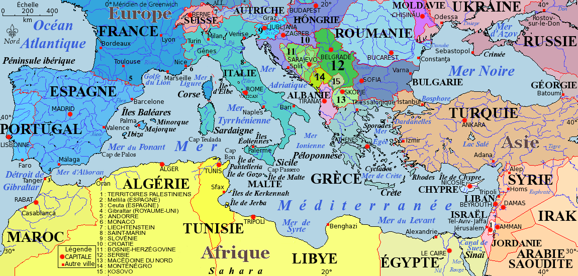
Español: Mapa del Mar Mediterráneo
Français : *Nom : Carte politique de la mer Méditerranée
- Description : carte de la mer Méditerranée, de ses principales mers, îles, villes, et de ses pays côtiers où :
- en verts figurent les pays issus de la Yougoslavie ;
- en bleus figurent les pays membres de l'Union européenne en juin 2005.
- Projection de Mercator
- Fonds de carte provenant de www.aquarius.geomar.de.
- Carte originale vierge disponible à Méditerranée.xcf
- Carte sous licence de documentation libre GNU (GFDL) :
- Permission vous est donnée de copier, distribuer et/ou modifier ce document selon les termes de la Licence GNU Free Documentation License, Version 1.2 ou ultérieure publiée par la Free Software Foundation ; sans sections inaltérables, sans texte de première page de couverture, sans texte de dernière page de couverture. Une copie de cette Licence est incluse dans la section appelée GNU Free Documentation License de ce document.
Copyright © août 2005 Idarvol

|
Permission is granted to copy, distribute and/or modify this document under the terms of the GNU Free Documentation License, Version 1.2 or any later version published by the Free Software Foundation; with no Invariant Sections, no Front-Cover Texts, and no Back-Cover Texts. A copy of the license is included in the section entitled GNU Free Documentation License. |
| This file is licensed under the Creative Commons Attribution-Share Alike 3.0 Unported license. | ||
| ||
| This licensing tag was added to this file as part of the GFDL licensing update. |
File history
Click on a date/time to view the file as it appeared at that time.
| Date/Time | Thumbnail | Dimensions | User | Comment | |
|---|---|---|---|---|---|
| current | 06:07, 22 August 2019 | | 1,150 × 550 (189 KB) | Eth00 (talk | contribs) | Corrections: Orthographe Liechtenstein Macédoine du Nord Mise en forme liste de pays |
| 16:52, 6 November 2017 |  | 1,150 × 550 (275 KB) | Mélomène (talk | contribs) | Distingué capitales, détails | |
| 11:53, 23 January 2016 |  | 1,150 × 550 (228 KB) | SenseiAC (talk | contribs) | Kosovo issu de l'ex-Yougoslavie --> vert. Ajout nom "Vatican" manquant. | |
| 18:58, 1 July 2014 |  | 1,150 × 550 (238 KB) | Spiridon Ion Cepleanu (talk | contribs) | Kosovo + Position correcte d'Izmir | |
| 09:39, 28 June 2014 |  | 1,150 × 550 (236 KB) | Spiridon Ion Cepleanu (talk | contribs) | Capitale, not "Catipale" (legend) | |
| 08:49, 28 June 2014 |  | 1,150 × 550 (233 KB) | Spiridon Ion Cepleanu (talk | contribs) | Some little changes again (rivers, Cyprus...) | |
| 17:15, 27 June 2014 |  | 1,150 × 550 (233 KB) | Spiridon Ion Cepleanu (talk | contribs) | Croatian islands in violet & some other little chenges | |
| 01:31, 21 February 2014 |  | 1,150 × 550 (222 KB) | SenseiAC (talk | contribs) | ~Update. A svg version could certainly be better. | |
| 22:02, 1 August 2008 |  | 1,150 × 550 (88 KB) | Lycaon (talk | contribs) | Reverted to version as of 20:31, 22 August 2005 | |
| 19:52, 30 July 2008 |  | 1,150 × 550 (88 KB) | Lycaon (talk | contribs) | Reverted to version as of 20:31, 22 August 2005 |
You cannot overwrite this file.
File usage on Commons
The following 2 pages use this file:
File usage on other wikis
The following other wikis use this file:
- Usage on an.wikipedia.org
- Usage on eo.wikipedia.org
- Usage on es.wikipedia.org
- Usage on frr.wikipedia.org
- Usage on fr.wikipedia.org
- Usage on it.wikipedia.org
- Usage on ja.wikipedia.org
- Usage on rm.wikipedia.org
- Usage on tr.wiktionary.org