File:Turkey Regions.png
Jump to navigation
Jump to search

Size of this preview: 800 × 357 pixels. Other resolutions: 320 × 143 pixels | 640 × 285 pixels | 1,278 × 570 pixels.
Original file (1,278 × 570 pixels, file size: 16 KB, MIME type: image/png)
Captions
Captions
Add a one-line explanation of what this file represents


|
This map has been uploaded by Electionworld from en.wikipedia.org to enable the |
Summary[edit]
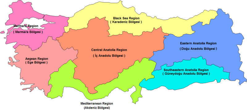
Map of the census-defined regions of Turkey. Names of the regions corrected on original Image (by User Rarelibra).Corrections are made by Mustafa Akalp.
Other versions[edit]


Licensing[edit]
| I, the copyright holder of this work, release this work into the public domain. This applies worldwide. In some countries this may not be legally possible; if so: I grant anyone the right to use this work for any purpose, without any conditions, unless such conditions are required by law. |
File history
Click on a date/time to view the file as it appeared at that time.
| Date/Time | Thumbnail | Dimensions | User | Comment | |
|---|---|---|---|---|---|
| current | 23:00, 28 November 2010 | | 1,278 × 570 (16 KB) | Ras67 (talk | contribs) | cropped and squeezed, transparence |
| 10:51, 17 December 2006 |  | 1,281 × 880 (50 KB) | Electionworld (talk | contribs) | {{ew|en|Mustafa Akalp}} == Summary == Map of the census-defined regions of Turkey. Names of the regions corrected on original Image (by User Rarelibra).Corrections are made by Mustafa Akalp. == Licensing == {{PD-self}} |
You cannot overwrite this file.
File usage on Commons
The following 7 pages use this file:
File usage on other wikis
The following other wikis use this file:
- Usage on an.wikipedia.org
- Usage on ar.wikipedia.org
- Usage on ast.wikipedia.org
- Usage on ay.wikipedia.org
- Usage on ba.wikipedia.org
- Usage on be-tarask.wikipedia.org
- Usage on be.wikipedia.org
- Usage on el.wikipedia.org
- Usage on en.wikipedia.org
- Usage on es.wikipedia.org
- Usage on eu.wikipedia.org
- Usage on fr.wikipedia.org
- Usage on gl.wikipedia.org
- Usage on hu.wikipedia.org
- Törökország földrajza
- Égei-tengeri régió
- Fekete-tengeri régió
- Márvány-tengeri régió
- Földközi-tengeri régió
- Sablon:Törökország régiói
- Törökország régiói
- Törökország közigazgatási egységei
- Közép-anatóliai régió
- Kelet-anatóliai régió
- Délkelet-anatóliai régió
- Törökország turisztikai látnivalói régiók szerint
- Szerkesztő:Kaleido1000/Földrajzi navigációs sablonok/Országok tartományai, települései, stb
- Usage on hy.wikipedia.org
- Usage on hyw.wikipedia.org
- Usage on it.wikipedia.org
- Usage on ja.wikipedia.org
- Usage on ja.wikibooks.org
- Usage on jv.wikipedia.org
- Usage on koi.wikipedia.org
- Usage on ko.wikipedia.org
- Usage on lrc.wikipedia.org
- Usage on mrj.wikipedia.org
- Usage on ms.wikipedia.org
View more global usage of this file.