File:Caucasus 300 map de.svg
Jump to navigation
Jump to search

Size of this PNG preview of this SVG file: 771 × 599 pixels. Other resolutions: 309 × 240 pixels | 618 × 480 pixels | 988 × 768 pixels | 1,280 × 995 pixels | 2,560 × 1,990 pixels | 1,155 × 898 pixels.
Original file (SVG file, nominally 1,155 × 898 pixels, file size: 4.44 MB)
Captions
Captions
Add a one-line explanation of what this file represents
Summary[edit]
| Description |
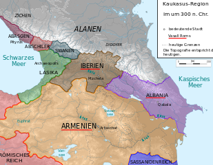
Deutsch: Kaukasus-Region um 300 n. Chr.
Quellen sind File:Geor_earliest_2A.jpg , Putzger historischer Weltatlas Ausgabe 2005, Heinz Fähnrich: Geschichte Georgiens von den Anfängen bis zur Mongolenherrschaft. Shaker, Aachen 1993, ISBN 3-86111-683-9., http://www.armenica.org/cgi-bin/armenica.cgi?178711717323498=1=3==Armenia==1=3=AAA |
||
| Date | |||
| Source | work by uploader, derivate of File:Caucasus_topographic_map-fr.svg | ||
| Author | Don-kun | ||
| Permission (Reusing this file) |
I, the copyright holder of this work, hereby publish it under the following licenses: This file is licensed under the Creative Commons Attribution-Share Alike 3.0 Unported license.
You may select the license of your choice. |

This W3C-unspecified vector image was created with Inkscape .
File history
Click on a date/time to view the file as it appeared at that time.
| Date/Time | Thumbnail | Dimensions | User | Comment | |
|---|---|---|---|---|---|
| current | 19:41, 17 August 2009 | | 1,155 × 898 (4.44 MB) | Don-kun (talk | contribs) | false version ;) |
| 19:37, 17 August 2009 |  | 1,155 × 898 (4.46 MB) | Don-kun (talk | contribs) | following Fähnrich, Iberia lost southern territories at the end of the rule of Amasasp III (260-265) | |
| 21:42, 8 August 2009 |  | 1,155 × 898 (4.44 MB) | Don-kun (talk | contribs) | colors like the others, corrections following armenica.org and Putzger and others about Roman conquest in Assyria in that time. | |
| 21:37, 29 March 2009 |  | 1,155 × 898 (4.49 MB) | Don-kun (talk | contribs) | {{Information |Description={{de|1=Kaukasus-Region um 300 n. Chr. Quellen sind http://commons.wikimedia.org/wiki/File:Geor_earliest_2A.jpg , Putzger historischer Weltatlas Ausgabe 2005, Heinz Fähnrich: ''Geschichte Georgiens von den Anfängen bis zur Mo |
You cannot overwrite this file.
File usage on Commons
The following 3 pages use this file:
File usage on other wikis
The following other wikis use this file:
- Usage on de.wikipedia.org
- Usage on pl.wikipedia.org