File:Distribution map of the French language in Europe.png
Jump to navigation
Jump to search
Size of this preview: 686 × 600 pixels. Other resolutions: 275 × 240 pixels | 549 × 480 pixels | 879 × 768 pixels | 1,096 × 958 pixels.
Original file (1,096 × 958 pixels, file size: 696 KB, MIME type: image/png)
Captions
Captions
Add a one-line explanation of what this file represents
| Description |
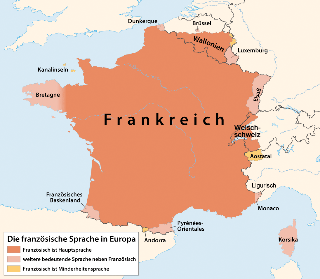
Deutsch: Karte der französischen Sprache in Europa
English: Distribution map of the French language in Europe |
| Date | |
| Source | Own work |
| Author | Maximilian Dörrbecker (Chumwa) |
| Permission (Reusing this file) |
I, the copyright holder of this work, hereby publish it under the following license: This file is licensed under the Creative Commons Attribution-Share Alike 2.5 Generic license.
Sie dürfen das Bild zu den folgenden Bedingungen nutzen:
|
| Other versions |
|

.png)
File history
Click on a date/time to view the file as it appeared at that time.
| Date/Time | Thumbnail | Dimensions | User | Comment | |
|---|---|---|---|---|---|
| current | 12:14, 27 December 2023 | | 1,096 × 958 (696 KB) | Ovinator (talk | contribs) | Korrektur Luxemburg; siehe hier |
| 20:27, 13 November 2017 |  | 1,096 × 958 (324 KB) | Albinfo (talk | contribs) | Schirftgrösse an vorherige Version angepasst | |
| 20:22, 13 November 2017 |  | 1,096 × 958 (324 KB) | Albinfo (talk | contribs) | Romanische Schweiz war eine falsche Bezeichnung | |
| 13:43, 1 December 2013 |  | 1,096 × 958 (154 KB) | Felisopus (talk | contribs) | Fix Ligurish | |
| 17:35, 1 June 2013 |  | 1,096 × 958 (150 KB) | Surtalnar (talk | contribs) | Komprimiert. | |
| 17:31, 1 June 2013 |  | 1,096 × 958 (154 KB) | Surtalnar (talk | contribs) | Französisch ist mindestens Minderheitensprache in Eupen-Malmedy. Es wird dort von dem Großteil der Bevölkerung gesprochen und das Gebiet ist Teil des Französischsprachigen/der Wallonischen Region. | |
| 07:54, 1 November 2009 |  | 1,096 × 958 (144 KB) | Chumwa (talk | contribs) | Pyrénées-Orientales eingearbeitet | |
| 07:24, 1 November 2009 |  | 1,096 × 958 (142 KB) | Chumwa (talk | contribs) | Dunkerque eingearbeitet | |
| 20:20, 31 October 2009 |  | 1,462 × 1,277 (201 KB) | Chumwa (talk | contribs) | {{Information |Description= {{ de }} Karte der französischen Sprache in Europa {{ en }} Distribution map of the French language in Europe |Source={{own}} |Date=2009-10 |Author= Maximilian Dörrbecker (Chumwa) |Perm |
You cannot overwrite this file.
File usage on Commons
The following 7 pages use this file:
- User:Chumwa/Gallery
- User:Chumwa/OgreBot/Travel and communication maps/2017 November 11-20
- User:Chumwa/OgreBot/Travel and communication maps/2023 December 21-31
- User:Magog the Ogre/Multilingual legend/2023 December 27-31
- File:Distribution map of the French language in Europe.png
- File:Distribution map of the French language in Europe (with Occitan).png
- File:Idioma francés.png
File usage on other wikis
The following other wikis use this file:
- Usage on de.wikipedia.org
- Usage on fy.wikipedia.org
- Usage on la.wikipedia.org
- Usage on pfl.wikipedia.org