File:World map 1815 (COV).jpg

Original file (4,000 × 2,304 pixels, file size: 1.49 MB, MIME type: image/jpeg)
Captions
Captions
Summary[edit]
.jpg&action=edit§ion=1)
| Description |
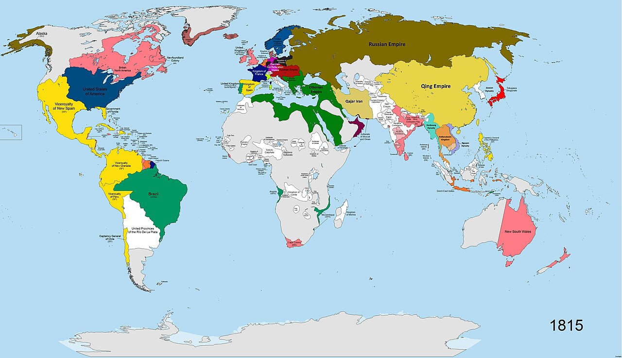
English: A map of the world in the year 1815 AD. States shown in colours:
Britain (pink), France (navy blue), Sweden (dark blue), Prussia (dark grey), the states of the German Confederation (pink), Austria (burgundy), Spain (yellow), Portugal (green-turquoise), Ottoman Empire (dark green), Iran (light green), Russia (brown), Netherlands (orange), Sardinia/Savoy (lime green), China (cream-yellow), Japan (bright red), Denmark (dull red), Oman (maroon-purple), USA (dark blue, similar to Sweden). All other states shown in white. Terra Nullis shown in grey. |
| Date | |
| Source | Own work |
| Author | SvoHljott |
Map covers entire globe. Research for accuracy took 5 months. Borders are as accurate as possible, where no maps of the individual states at the time existed, borders are based on rivers and cities.
| Maps of world history | |
| BC | |
|
| |
| AD |
1 · 50 · 100 · 200 · 250 · 300 · 400 · 500 · 700 · 750 · 820 · 900 · 1200 · 1500 · 1556 · 1648 · 1700 · 1750 · 1815 · 1859 · 1871 · 1914 · 1935 · 1954 · 1989 · 2000 · |
|
Maps of colonization history | |
|
see also: Eastern Hemisphere only maps template (1300BC-1500AD) | |
| (this template: · view · discuss ) | |
._LOC_2001620596.jpg)
Licensing[edit]
.jpg&action=edit§ion=2)
- You are free:
- to share – to copy, distribute and transmit the work
- to remix – to adapt the work
- Under the following conditions:
- attribution – You must give appropriate credit, provide a link to the license, and indicate if changes were made. You may do so in any reasonable manner, but not in any way that suggests the licensor endorses you or your use.
- share alike – If you remix, transform, or build upon the material, you must distribute your contributions under the same or compatible license as the original.
File history
Click on a date/time to view the file as it appeared at that time.
| Date/Time | Thumbnail | Dimensions | User | Comment | |
|---|---|---|---|---|---|
| current | 12:32, 28 March 2023 | | 4,000 × 2,304 (1.49 MB) | Yourlocallordandsavior (talk | contribs) | Minor tweaks. |
| 12:18, 28 March 2023 |  | 4,000 × 2,304 (1.5 MB) | Yourlocallordandsavior (talk | contribs) | Improved Mainland SE Asia's borders. | |
| 08:43, 19 March 2023 |  | 4,000 × 2,304 (896 KB) | Achim55 (talk | contribs) | Reverted to version as of 17:26, 3 October 2020 (UTC) | |
| 06:15, 18 March 2023 |  | 4,500 × 2,592 (2.51 MB) | Dndnrmn1 (talk | contribs) | Reverted to version as of 17:57, 1 May 2014 (UTC) | |
| 17:26, 3 October 2020 |  | 4,000 × 2,304 (896 KB) | Ориенталист (talk | contribs) | minor coppections | |
| 17:57, 1 May 2014 |  | 4,500 × 2,592 (2.51 MB) | SvoHljott (talk | contribs) | Added Company Raj label. | |
| 14:33, 1 May 2014 |  | 4,500 × 2,592 (2.5 MB) | SvoHljott (talk | contribs) | Added labels for Cape Verde, the Falklands, the Guianas and Goa. | |
| 12:45, 1 May 2014 |  | 4,500 × 2,592 (1.45 MB) | SvoHljott (talk | contribs) | Added Sao Tome and Principe, Bioko and the African Great Lake States labels. | |
| 12:15, 1 May 2014 |  | 4,500 × 2,592 (1.45 MB) | SvoHljott (talk | contribs) | User created page with UploadWizard |
You cannot overwrite this file.
File usage on Commons
The following page uses this file:
File usage on other wikis
The following other wikis use this file:
- Usage on de.wikipedia.org
- Usage on en.wikipedia.org
- Usage on es.wikipedia.org
- Usage on eu.wikipedia.org
- Usage on lv.wikipedia.org
- Usage on nl.wikipedia.org
- Usage on pap.wikipedia.org
- Usage on sr.wikipedia.org
.jpg&oldid=866607137)