File:Map rajasthan dist num blank.png
Jump to navigation
Jump to search

Size of this preview: 659 × 600 pixels. Other resolutions: 264 × 240 pixels | 527 × 480 pixels | 781 × 711 pixels.
Original file (781 × 711 pixels, file size: 50 KB, MIME type: image/png)
Captions
Captions
Add a one-line explanation of what this file represents
Summary[edit]
| Description |
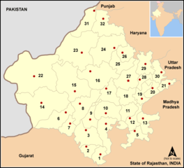
Map of w:Rajasthan state, India with district boundaries - districts are numbered. Legends:
|
| Date | |
| Source | No machine-readable source provided. Own work assumed (based on copyright claims). |
| Author | User:Miljoshi |
Licensing[edit]
I, the copyright holder of this work, hereby publish it under the following licenses:

|
Permission is granted to copy, distribute and/or modify this document under the terms of the GNU Free Documentation License, Version 1.2 or any later version published by the Free Software Foundation; with no Invariant Sections, no Front-Cover Texts, and no Back-Cover Texts. A copy of the license is included in the section entitled GNU Free Documentation License. |
| This file is licensed under the Creative Commons Attribution-Share Alike 3.0 Unported license. | ||
| ||
| This licensing tag was added to this file as part of the GFDL licensing update. |
This file is licensed under the Creative Commons Attribution-Share Alike 2.5 Generic, 2.0 Generic and 1.0 Generic license.
- You are free:
- to share – to copy, distribute and transmit the work
- to remix – to adapt the work
- Under the following conditions:
- attribution – You must give appropriate credit, provide a link to the license, and indicate if changes were made. You may do so in any reasonable manner, but not in any way that suggests the licensor endorses you or your use.
- share alike – If you remix, transform, or build upon the material, you must distribute your contributions under the same or compatible license as the original.
You may select the license of your choice.
File history
Click on a date/time to view the file as it appeared at that time.
| Date/Time | Thumbnail | Dimensions | User | Comment | |
|---|---|---|---|---|---|
| current | 14:26, 7 January 2006 | | 781 × 711 (50 KB) | Miljoshi (talk | contribs) | Map of w:Rajasthan state, India with district boundaries - districts are numbered. Category:Rajasthan district maps |
You cannot overwrite this file.
File usage on Commons
The following 3 pages use this file:
File usage on other wikis
The following other wikis use this file:
- Usage on bn.wikipedia.org
- Usage on ca.wikipedia.org
- Usage on da.wikipedia.org
- Usage on fr.wikipedia.org
- District de Bharatpur
- District de Bhilwara
- District de Tonk
- District de Bikaner
- District de Sri Ganganagar
- District de Hanumangarh
- District de Jaipur
- District de Jhunjhunu
- District de Sikar
- District de Barmer
- District de Jaisalmer
- District de Jalore
- District de Jodhpur
- District de Baran
- District de Bundi
- District de Chittorgarh
- District de Rajsamand
- District d'Udaipur
- Usage on it.wikipedia.org
- Usage on ja.wikipedia.org
- Usage on ml.wikipedia.org
- Usage on ne.wikipedia.org
- Usage on or.wikipedia.org
- Usage on pa.wikipedia.org
- Usage on pnb.wikipedia.org
- Usage on pt.wikipedia.org
- Usage on sat.wikipedia.org
View more global usage of this file.