File:Map for Gupta Empire and tributaries.svg
Jump to navigation
Jump to search

Size of this PNG preview of this SVG file: 572 × 600 pixels. Other resolutions: 229 × 240 pixels | 458 × 480 pixels | 732 × 768 pixels | 977 × 1,024 pixels | 1,953 × 2,048 pixels | 700 × 734 pixels.
Original file (SVG file, nominally 700 × 734 pixels, file size: 1.49 MB)
Captions
Captions
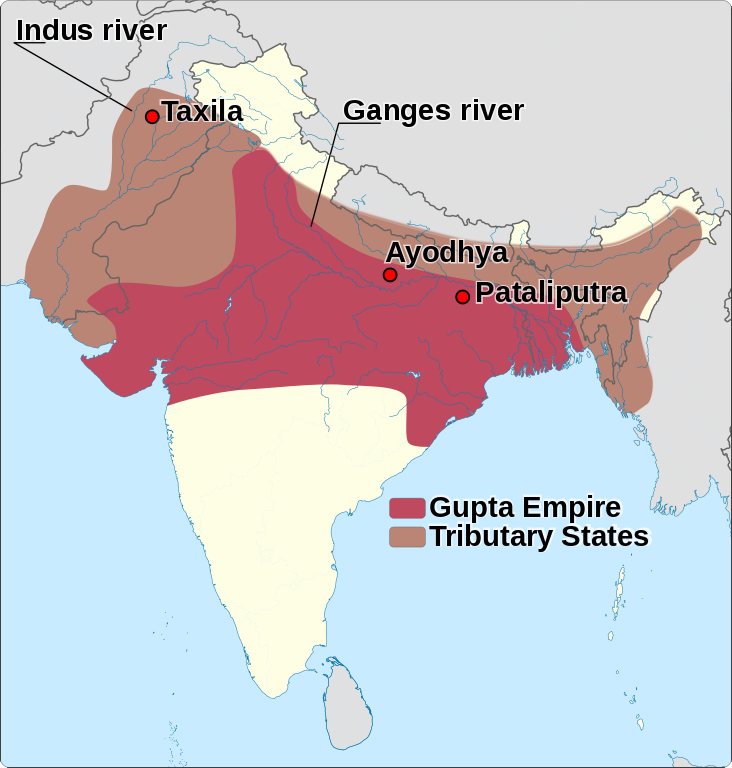
Gupta Empire (320 - 600 AD) with its tributary states.
Summary[edit]
| Description |
English: Gupta Empire (320 - 600 AD) with its tributary states.
|
|||||||||||||||||||||||||||||||||||||
| Date | ||||||||||||||||||||||||||||||||||||||
| Source |
Own work based on: India location map.svg
Information from:
|
|||||||||||||||||||||||||||||||||||||
| Author | Goran tek-en | |||||||||||||||||||||||||||||||||||||
| Permission (Reusing this file) |
This file is licensed under the Creative Commons Attribution-Share Alike 4.0 International license. Attribution: Goran tek-en
|
|||||||||||||||||||||||||||||||||||||
| Other versions |
|
|||||||||||||||||||||||||||||||||||||
| SVG development | This vector image was created with Inkscape. |
|||||||||||||||||||||||||||||||||||||

.jpg)

| Object location | | View this and other nearby images on: OpenStreetMap |
|---|


File history
Click on a date/time to view the file as it appeared at that time.
| Date/Time | Thumbnail | Dimensions | User | Comment | |
|---|---|---|---|---|---|
| current | 15:17, 2 March 2014 | | 700 × 734 (1.49 MB) | Goran tek-en (talk | contribs) | User created page with UploadWizard |
You cannot overwrite this file.
File usage on Commons
The following 2 pages use this file:
File usage on other wikis
The following other wikis use this file:
- Usage on ar.wikipedia.org
- Usage on ar.wikiversity.org
- Usage on el.wikipedia.org
- Usage on en.wikipedia.org
- Usage on id.wikipedia.org
- Usage on pa.wikipedia.org
- Usage on pnb.wikipedia.org
- Usage on ur.wikipedia.org