File:Mozambique carte.png
Jump to navigation
Jump to search
Size of this preview: 278 × 600 pixels. Other resolutions: 111 × 240 pixels | 332 × 716 pixels.
Original file (332 × 716 pixels, file size: 25 KB, MIME type: image/png)
Captions
Captions
Add a one-line explanation of what this file represents
Summary[edit]
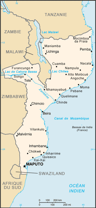
| Description | Map in French of Mozambique |
| Date | |
| Source |
Formerly on the French speaking Wikipedia CIA World Factbook |
| Author | Translation : fr:Nécropotame |
| Permission (Reusing this file) |
PD |
| Other versions | Original version in English : Image:Mz-map.png |
Français : * Sujet : Carte en français du Mozambique ;
- Source : CIA World Factbook ;
- Auteur de la traduction : fr:Nécropotame (Auparavant sur la Wikipédia francophone) ;
- Date : Octobre 2005.
File history on the French speaking Wikipedia :
(suppr) (actu) 14 janvier 2006 à 06:39 . . Nécropotame (Discuter | Contributions) . . 332×716 (25 758 octets) (carte du Mozambique - source https://www.cia.gov/library/publications/the-world-factbook/geos/mz.html)
(suppr) (rétab) 11 novembre 2005 à 08:25 . . Nécropotame (Discuter | Contributions) . . 332×716 (26 507 octets)
(suppr) (rétab) 31 octobre 2005 à 08:30 . . Nécropotame (Discuter | Contributions) . . 332×716 (26 440 octets)
(suppr) (rétab) 31 octobre 2005 à 07:14 . . Nécropotame (Discuter | Contributions) . . 332×716 (25 770 octets)
(suppr) (rétab) 13 juin 2004 à 17:22 . . Luna04 (Discuter | Contributions) . . 332×716 (13 837 octets) (carte du Mozambique - source https://www.cia.gov/library/publications/the-world-factbook/geos/mz.html - {{DomainePublic}})
(suppr) (rétab) 13 juin 2004 à 17:16 . . Luna04 (Discuter | Contributions) . . 332×716 (13 837 octets) (carte du Mozambique - source https://www.cia.gov/library/publications/the-world-factbook/geos/mz.html - {{DomainePublic}})
Licensing[edit]
This image is in the public domain because it contains materials that originally came from the United States Central Intelligence Agency's World Factbook.
|
 |
File history
Click on a date/time to view the file as it appeared at that time.
| Date/Time | Thumbnail | Dimensions | User | Comment | |
|---|---|---|---|---|---|
| current | 19:36, 14 September 2006 | | 332 × 716 (25 KB) | Sting (talk | contribs) | {{Information |Description=Map in French of Mozambique |Source=''Formerly on the French speaking Wikipedia''<br/>[https://www.cia.gov/cia/publications/factbook/index.html CIA World Factbook] |Date=October 2005 |Author=Translation : [[:fr:User:Nécropotame |
You cannot overwrite this file.
File usage on Commons
There are no pages that use this file.
File usage on other wikis
The following other wikis use this file:
- Usage on be-tarask.wikipedia.org
- Usage on fr.wikipedia.org
- Usage on mg.wikipedia.org
- Usage on nl.wikipedia.org
- Usage on os.wikipedia.org
- Usage on ro.wikipedia.org
- Usage on scn.wikipedia.org
- Usage on sv.wikipedia.org
- Usage on to.wikipedia.org
- Usage on uk.wikipedia.org
- Usage on wo.wikipedia.org