File:Tuvalu-CIA WFB Map.png
Jump to navigation
Jump to search
No higher resolution available.
Tuvalu-CIA_WFB_Map.png (329 × 352 pixels, file size: 5 KB, MIME type: image/png)
Captions
Captions
Add a one-line explanation of what this file represents
| Description |
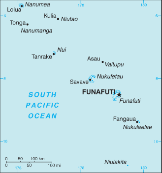
English: Map of Tuvalu, showing major towns and islands. |
|||
| Date | ||||
| Source | CIA, The World Factbook, 2004 (internet version) | |||
| Author | CIA | |||
| Permission (Reusing this file) |
|

File history
Click on a date/time to view the file as it appeared at that time.
| Date/Time | Thumbnail | Dimensions | User | Comment | |
|---|---|---|---|---|---|
| current | 09:18, 27 March 2005 | | 329 × 352 (5 KB) | Wolfman~commonswiki (talk | contribs) | {{CIA-map}} |
You cannot overwrite this file.
File usage on Commons
The following 2 pages use this file:
File usage on other wikis
The following other wikis use this file:
- Usage on af.wikipedia.org
- Usage on ast.wikipedia.org
- Usage on avk.wikipedia.org
- Usage on bn.wikipedia.org
- Usage on ca.wikipedia.org
- Usage on cs.wikipedia.org
- Usage on de.wikivoyage.org
- Usage on en.wikipedia.org
- Usage on en.wikisource.org
- Usage on eo.wikipedia.org
- Usage on es.wikipedia.org
- Usage on fa.wikipedia.org
- Usage on fi.wikipedia.org
- Usage on fr.wikipedia.org
- Usage on fy.wikipedia.org
- Usage on gl.wikipedia.org
- Usage on gom.wikipedia.org
- Usage on he.wikipedia.org
- טובאלו
- תבנית:הידעת? 13 בספטמבר - סדרה 2
- ויקיפדיה:הידעת?/החלפת קטעי "הידעת?"/ארכיון דיונים שהסתיימו - ההצעה התקבלה/2
- שיחת תבנית:הידעת? 13 בספטמבר - סדרה 2
- ויקיפדיה:הידעת?/החלפת קטעי "הידעת?"/ארכיון דיונים שהסתיימו - ההצעה התקבלה/3
- פורטל:מדינות העולם/הידעת?/קטעי הידעת?
- פורטל:מדינות העולם/הידעת?/6
- פורטל:תקשורת/הידעת?/קטעי הידעת
View more global usage of this file.