File:Iraq.A2003060.0750.500m.jpg
Jump to navigation
Jump to search

Size of this preview: 461 × 599 pixels. Other resolutions: 184 × 240 pixels | 369 × 480 pixels | 591 × 768 pixels | 788 × 1,024 pixels | 2,000 × 2,600 pixels.
Original file (2,000 × 2,600 pixels, file size: 1,012 KB, MIME type: image/jpeg)
Captions
Captions
Add a one-line explanation of what this file represents
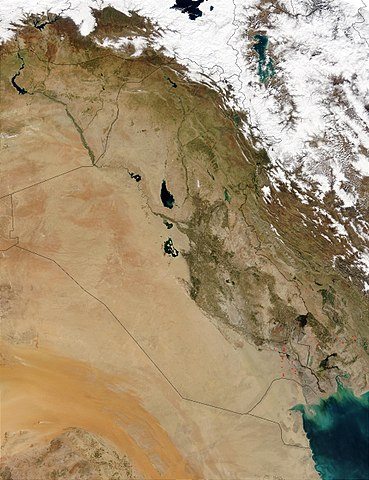
This Moderate Resolution Imaging Spectroradiometer (MODIS) image from March 1, 2003, shows numerous oil well flares (the burning off of combustible gases associated with oil) in southern Iraq (center). The way the active hot spots, marked in red, line up almost vertically suggests they are along a pipeline. Meanwhile, hot spots in southern Iran (right) are likely agricultural fires.
http://visibleearth.nasa.gov/view_rec.php?id=5166
| This file is in the public domain in the United States because it was solely created by NASA. NASA copyright policy states that "NASA material is not protected by copyright unless noted". (See Template:PD-USGov, NASA copyright policy page or JPL Image Use Policy.) | ||
 |
Warnings:
|
File history
Click on a date/time to view the file as it appeared at that time.
| Date/Time | Thumbnail | Dimensions | User | Comment | |
|---|---|---|---|---|---|
| current | 15:05, 26 October 2005 | | 2,000 × 2,600 (1,012 KB) | Brian0918 (talk | contribs) | This Moderate Resolution Imaging Spectroradiometer (MODIS) image from March 1, 2003, shows numerous oil well flares (the burning off of combustible gases associated with oil) in southern Iraq (center). The way the active hot spots, marked in red, line up |
You cannot overwrite this file.
File usage on Commons
The following page uses this file:
File usage on other wikis
The following other wikis use this file:
- Usage on ar.wikipedia.org
- Usage on ar.wikiquote.org
- Usage on da.wikipedia.org
- Usage on en.wikipedia.org
- Usage on fi.wikipedia.org
- Usage on gl.wikipedia.org
- Usage on hr.wikipedia.org
- Usage on hy.wikipedia.org
- Usage on ka.wikipedia.org
- Usage on km.wikipedia.org
- Usage on ko.wikipedia.org
- Usage on lt.wikipedia.org
- Usage on mn.wikipedia.org
- Usage on nn.wikipedia.org
- Usage on no.wikipedia.org
- Usage on nrm.wikipedia.org
- Usage on pl.wikipedia.org
- Usage on pt.wikipedia.org
- Usage on sh.wikipedia.org
- Usage on sl.wikipedia.org
- Usage on sr.wikipedia.org
- Usage on sv.wikipedia.org
- Usage on te.wikipedia.org
- Usage on tr.wikipedia.org
- Usage on uk.wikipedia.org
- Usage on zh.wikipedia.org