File:Burma-CIA WFB Map.png
Jump to navigation
Jump to search
Size of this preview: 275 × 598 pixels. Other resolutions: 110 × 240 pixels | 329 × 716 pixels.
Original file (329 × 716 pixels, file size: 32 KB, MIME type: image/png)
Captions
Captions
Add a one-line explanation of what this file represents
Summary[edit]
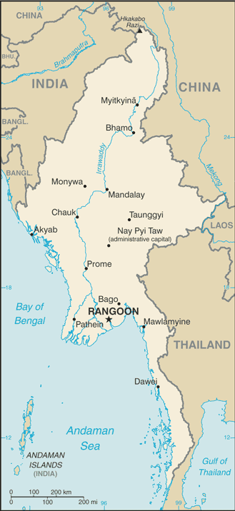
| Description | Burma (Myanmar) map from CIA World Factbook |
| Date | |
| Source |
CIA World Factbook, converted from original GIF format |
| Author | United States Central Intelligence Agency |
| Other versions |
.png)
Licensing[edit]
This image is in the public domain because it contains materials that originally came from the United States Central Intelligence Agency's World Factbook.
|
 |
File history
Click on a date/time to view the file as it appeared at that time.
| Date/Time | Thumbnail | Dimensions | User | Comment | |
|---|---|---|---|---|---|
| current | 01:45, 20 January 2007 | | 329 × 716 (32 KB) | Hoshie (talk | contribs) | Updated map from the CIA Factbook, 18 Jan 07 rev. Source: https://www.cia.gov/cia/publications/factbook/maps/bm-map.gif |
| 09:12, 27 March 2005 |  | 296 × 642 (18 KB) | Wolfman~commonswiki (talk | contribs) | {{CIA-map}} |
You cannot overwrite this file.
File usage on Commons
The following 3 pages use this file:
File usage on other wikis
The following other wikis use this file:
- Usage on af.wikipedia.org
- Usage on ar.wikipedia.org
- Usage on azb.wikipedia.org
- Usage on blk.wikipedia.org
- Usage on bn.wikipedia.org
- Usage on ckb.wikipedia.org
- Usage on de.wikipedia.org
- Usage on en.wikipedia.org
- Usage on en.wikisource.org
- Usage on en.wikivoyage.org
- Usage on en.wiktionary.org
- Usage on eo.wikipedia.org
- Usage on es.wikinews.org
- Usage on fa.wikipedia.org
- Usage on gom.wikipedia.org
- Usage on hu.wikipedia.org
- Usage on ilo.wikipedia.org
- Usage on io.wikipedia.org
- Usage on it.wikipedia.org
- Usage on kk.wikipedia.org
- Usage on km.wikipedia.org
- Usage on kn.wikipedia.org
- Usage on lt.wiktionary.org
- Usage on mnw.wiktionary.org
- Usage on my.wikipedia.org
- Usage on nl.wikipedia.org
- Usage on nn.wikipedia.org
- Usage on pl.wikipedia.org
View more global usage of this file.