File:South Ossetia physical map.svg
Jump to navigation
Jump to search

Size of this PNG preview of this SVG file: 600 × 531 pixels. Other resolutions: 271 × 240 pixels | 542 × 480 pixels | 868 × 768 pixels | 1,157 × 1,024 pixels | 2,314 × 2,048 pixels.
Original file (SVG file, nominally 600 × 531 pixels, file size: 886 KB)
Captions
Captions
Add a one-line explanation of what this file represents
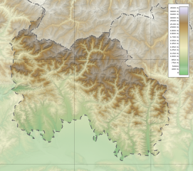
| Description | South Ossetia physical map |
| Date | 12-06-2010 |
| Source |
|
| Author | Bouron |
I, the copyright holder of this work, hereby publish it under the following licenses:
This file is licensed under the Creative Commons Attribution-Share Alike 3.0 Unported license.
- You are free:
- to share – to copy, distribute and transmit the work
- to remix – to adapt the work
- Under the following conditions:
- attribution – You must give appropriate credit, provide a link to the license, and indicate if changes were made. You may do so in any reasonable manner, but not in any way that suggests the licensor endorses you or your use.
- share alike – If you remix, transform, or build upon the material, you must distribute your contributions under the same or compatible license as the original.

|
Permission is granted to copy, distribute and/or modify this document under the terms of the GNU Free Documentation License, Version 1.2 or any later version published by the Free Software Foundation; with no Invariant Sections, no Front-Cover Texts, and no Back-Cover Texts. A copy of the license is included in the section entitled GNU Free Documentation License. |
You may select the license of your choice.
File history
Click on a date/time to view the file as it appeared at that time.
| Date/Time | Thumbnail | Dimensions | User | Comment | |
|---|---|---|---|---|---|
| current | 17:28, 6 March 2017 | | 600 × 531 (886 KB) | Giorgi Balakhadze (talk | contribs) | rv of sockpuppet. Reverted to version as of 08:48, 28 August 2016 (UTC) |
| 17:46, 28 August 2016 |  | 600 × 531 (886 KB) | Turnless (talk | contribs) | Reverted to version as of 05:49, 28 August 2016 (UTC) That is not necessary on Commons, there is no NPOV policy like on Wikipedia. Stop disrupting the file. | |
| 08:48, 28 August 2016 |  | 600 × 531 (886 KB) | Beqabai (talk | contribs) | Reverted to version as of 14:25, 1 August 2016 (UTC) This map makes no difference between de facto and international borders! | |
| 05:49, 28 August 2016 |  | 600 × 531 (886 KB) | Crushedkop (talk | contribs) | Reverted to version as of 00:14, 15 February 2015 (UTC) Far too much unnecessary space in between the disputd border. Ruins the shape of the region | |
| 14:25, 1 August 2016 |  | 600 × 531 (886 KB) | Beqabai (talk | contribs) | Reverted to version as of 18:07, 14 February 2015 (UTC) | |
| 00:14, 15 February 2015 |  | 600 × 531 (886 KB) | Leftcry (talk | contribs) | Reverted to version as of 20:42, 20 February 2011 The border was fine | |
| 18:07, 14 February 2015 |  | 600 × 531 (886 KB) | Giorgi Balakhadze (talk | contribs) | Fixing border | |
| 20:42, 20 February 2011 |  | 600 × 531 (886 KB) | Bouron (talk | contribs) | reloaded | |
| 08:42, 12 June 2010 |  | 6,082 × 5,404 (548 KB) | Bouron (talk | contribs) | fixed | |
| 08:19, 12 June 2010 |  | 6,082 × 5,404 (3.57 MB) | Bouron (talk | contribs) | fixed |
You cannot overwrite this file.
File usage on Commons
The following page uses this file:
File usage on other wikis
The following other wikis use this file:
- Usage on az.wikipedia.org
- Usage on de.wiktionary.org
- Usage on es.wikipedia.org
- Usage on hu.wikipedia.org
- Usage on la.wikipedia.org
- Usage on mn.wikipedia.org
- Usage on nl.wikipedia.org
- Usage on os.wikipedia.org
- Usage on ru.wikipedia.org
- Usage on uk.wikipedia.org