File:Foreign relations of Israel (map).png
Jump to navigation
Jump to search
Size of this preview: 800 × 353 pixels. Other resolutions: 320 × 141 pixels | 640 × 282 pixels | 1,425 × 628 pixels.
Original file (1,425 × 628 pixels, file size: 58 KB, MIME type: image/png)
Captions
Captions
Add a one-line explanation of what this file represents

|
This file may be updated to reflect new information. If you wish to use a specific version of the file without new updates being mirrored, please upload the required version as a separate file. |
Summary[edit]
| Description |
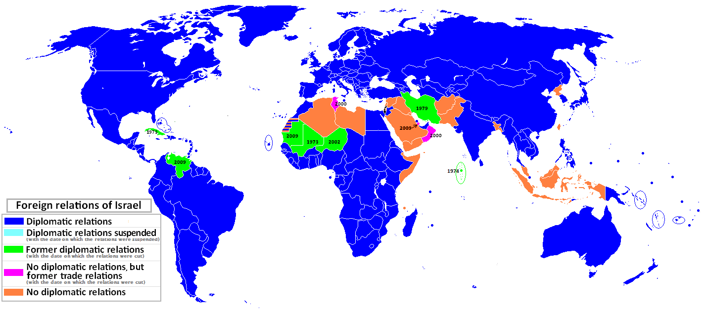
English: Map of the World showing status of diplomatic relations with Israel, updated to August 2020. |
||
| Date | |||
| Source | Own work based upon File:World map model.png | ||
| Author | Davshul | ||
| Permission (Reusing this file) |
|
||
| Other versions |
|


.png&action=edit§ion=1)
File history
Click on a date/time to view the file as it appeared at that time.
.png&dir=prev)
.png&offset=20200814072225)
.png&offset=&limit=20)
.png&offset=&limit=50)
.png&offset=&limit=100)
.png&offset=&limit=250)
.png&offset=&limit=500)
| Date/Time | Thumbnail | Dimensions | User | Comment | |
|---|---|---|---|---|---|
| current | 21:45, 29 May 2021 | | 1,425 × 628 (58 KB) | Zhomron (talk | contribs) | +Morocco |
| 18:36, 8 January 2021 |  | 1,425 × 628 (59 KB) | Zhomron (talk | contribs) | Sudan's formalized, signed Abraham Accords. | |
| 22:43, 14 December 2020 |  | 1,425 × 628 (60 KB) | Gugganij (talk | contribs) | +Bhutan | |
| 20:38, 4 November 2020 |  | 1,425 × 628 (64 KB) | Sakiv (talk | contribs) | Reverted to version as of 03:42, 29 September 2020 (UTC) no diplomatic relations yet | |
| 14:27, 25 October 2020 |  | 1,425 × 628 (64 KB) | CadAPL (talk | contribs) | update Sudan! | |
| 03:42, 29 September 2020 |  | 1,425 × 628 (64 KB) | Heitordp (talk | contribs) | Corrected Maldives, adjusted borders, colored gray islands | |
| 19:45, 11 September 2020 |  | 1,425 × 628 (64 KB) | GrecoArm (talk | contribs) | +Kosovo | |
| 19:28, 11 September 2020 |  | 1,425 × 628 (64 KB) | CadAPL (talk | contribs) | UAE+Bahrain | |
| 19:19, 16 August 2020 |  | 1,425 × 628 (64 KB) | Semsûrî (talk | contribs) | Reverted to version as of 21:35, 1 January 2020 (UTC) source needed | |
| 07:22, 14 August 2020 |  | 1,425 × 628 (64 KB) | AKS471883 (talk | contribs) | Venezuela and UAE |
You cannot overwrite this file.
File usage on Commons
The following 8 pages use this file:
- User:Geagea/Israel/2016 July 26
- User:Geagea/Politics of Israel/2019 January 16
- User:Geagea/Politics of Israel/2019 January 20
- File:Diplomatic relations of Israel.svg
- File:Foreign relations of Israel (map)-ar.png
- File:Foreign relations of Israel Map July 2011-ar.png
- File:Foreign relations of Israel Map July 2011.PNG (file redirect)
-ar.png)
File usage on other wikis
The following other wikis use this file:
- Usage on ar.wikipedia.org
- Usage on ay.wikipedia.org
- Usage on az.wikipedia.org
- Usage on bat-smg.wikipedia.org
- Usage on cs.wikipedia.org
- Usage on de.wikipedia.org
- Usage on en.wikipedia.org
- Usage on es.wikipedia.org
- Usage on fa.wikipedia.org
- Usage on fi.wikipedia.org
- Usage on he.wikipedia.org
- Usage on hy.wikipedia.org
- Usage on it.wikipedia.org
- Usage on ja.wikipedia.org
- Usage on ka.wikipedia.org
- Usage on ko.wikipedia.org
- Usage on mn.wikipedia.org
- Usage on nl.wikipedia.org
- Usage on pl.wikipedia.org
- Usage on pnb.wikipedia.org
- Usage on te.wikipedia.org
- Usage on th.wikipedia.org
- Usage on uk.wikipedia.org
- Usage on ur.wikipedia.org
- Usage on uz.wikipedia.org
- Usage on vi.wikipedia.org
- Usage on zh.wikipedia.org
.png&oldid=817550773)