File:BayofPlentyA2002296.jpg
Jump to navigation
Jump to search

Size of this preview: 427 × 599 pixels. Other resolutions: 171 × 240 pixels | 616 × 864 pixels.
Original file (616 × 864 pixels, file size: 493 KB, MIME type: image/jpeg)
Captions
Captions
Add a one-line explanation of what this file represents
Summary[edit]
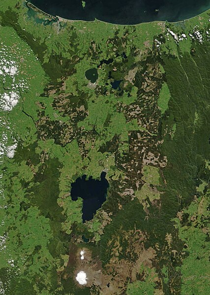
| Description | Bay of Plenty, North Island, New Zealand, from the Bay of Plenty coast to Mounts Tongariro, Ngauruhoe, and Ruapehu (at bottom of picture). Also shows Lake Taupo and the Rotorua Lakes. This scene was acquired by the Moderate Resolution Imaging Spectroradiometer (MODIS), flying aboard NASA’s Terra satellite, on October 23, 2002 |
| Date | |
| Source | http://veimages.gsfc.nasa.gov/4859/NewZealand.A2002296.2220.250m.jpg, cropped. |
| Author | Jacques Descloitres, MODIS Rapid Response Team, NASA/GSFC |
| Permission (Reusing this file) |
NASA, public domain |
Licensing[edit]
| This file is in the public domain in the United States because it was solely created by NASA. NASA copyright policy states that "NASA material is not protected by copyright unless noted". (See Template:PD-USGov, NASA copyright policy page or JPL Image Use Policy.) | ||
 |
Warnings:
|
File history
Click on a date/time to view the file as it appeared at that time.
| Date/Time | Thumbnail | Dimensions | User | Comment | |
|---|---|---|---|---|---|
| current | 00:20, 24 August 2007 | | 616 × 864 (493 KB) | Kahuroa (talk | contribs) | == Summary == {{Information |Description=Bay of Plenty, North Island, New Zealand, from the Bay of Plenty coast to Mounts Tongariro, Ngauruhoe, and Ruapehu (at bottom of picture). Also shows Lake Taupo and the Rotorua Lakes. This scene was acquired by the |
You cannot overwrite this file.
File usage on Commons
There are no pages that use this file.
File usage on other wikis
The following other wikis use this file:
- Usage on en.wikipedia.org
- Usage on mi.wikipedia.org
- Ngāti Tūrangitukua
- Te Arawa
- Ngāti Hikairo (Ngāti Tūwharetoa ki Tongariro)
- Ngāti Hinemihi (Ngāti Tūwharetoa)
- Ngāti Hinemihi (Ngāti Tūwharetoa ki Tongariro)
- Ngāti Kurapoto
- Ngāti Kurauia
- Ngāti Manunui (Ngāti Tūwharetoa ki Tongariro)
- Ngāti Meremere
- Ngāti Moekino
- Ngāti Parekawa (Ngāti Tūwharetoa ki Tongariro)
- Ngāti Rauhotu
- Ngāti Rongomai (Ngāti Tūwharetoa ki Tongariro)
- Ngāti Rua (Ngāti Tūwharetoa ki Tongariro)
- Ngāti Rungarangi
- Ngāti Tama (Ngāti Tūwharetoa ki Tongariro)
- Ngāti Tarakaiahi
- Ngāti Te Aho
- Ngāti Te Kohera (Ngāti Tūwharetoa ki Tongariro)
- Ngāti Te Marangataua
- Ngāti Te Rangiita
- Ngāti Tiherau
- Ngāti Turumakina
- Ngāti Tū Te Mahuta
- Ngāti Tū Te Tawhā
- Ngāti Tūtemohuta
- Ngāti Tūwharetoa ki Pūtauaki
- Ngāti Tūwharetoa ki Tongariro
- Ngāti Uenuku (Ngāti Tūwharetoa ki Tongariro)
- Ngāti Waewae (Ngāti Tūwharetoa ki Tongariro)
- Ngāi Tūhourangi
- Ngāti Hinemihi (Tūhourangi)
- Ngāti Mākino (Waitaha)
- Ngāti Te Āpiti (Tūhourangi)
- Ngāti Tāoi
- Ngāti Tū Teamutu
- Ngāti Tūmatawera
- Ngāti Tūohonoa
- Ngāti Umukaria
- Ngāti Uruhina (Tūhourangi)
- Ngāti Whakahemo (Waitaha)
- Ngāti Wāhiao
- Ngāti Āpū Moana
- Tūhourangi
- Waitaha (Te Arawa)
- Ngāti Moemiti
- Ngāti Tawakepito
- Ngāti Mārukukere
- Ngāti Moko
View more global usage of this file.