File:India Karnataka location map.svg
Jump to navigation
Jump to search

Size of this PNG preview of this SVG file: 423 × 600 pixels. Other resolutions: 169 × 240 pixels | 338 × 480 pixels | 542 × 768 pixels | 722 × 1,024 pixels | 1,445 × 2,048 pixels | 898 × 1,273 pixels.
Original file (SVG file, nominally 898 × 1,273 pixels, file size: 759 KB)
Captions
Captions
Bidadi town in Karnataka, India
| Description |
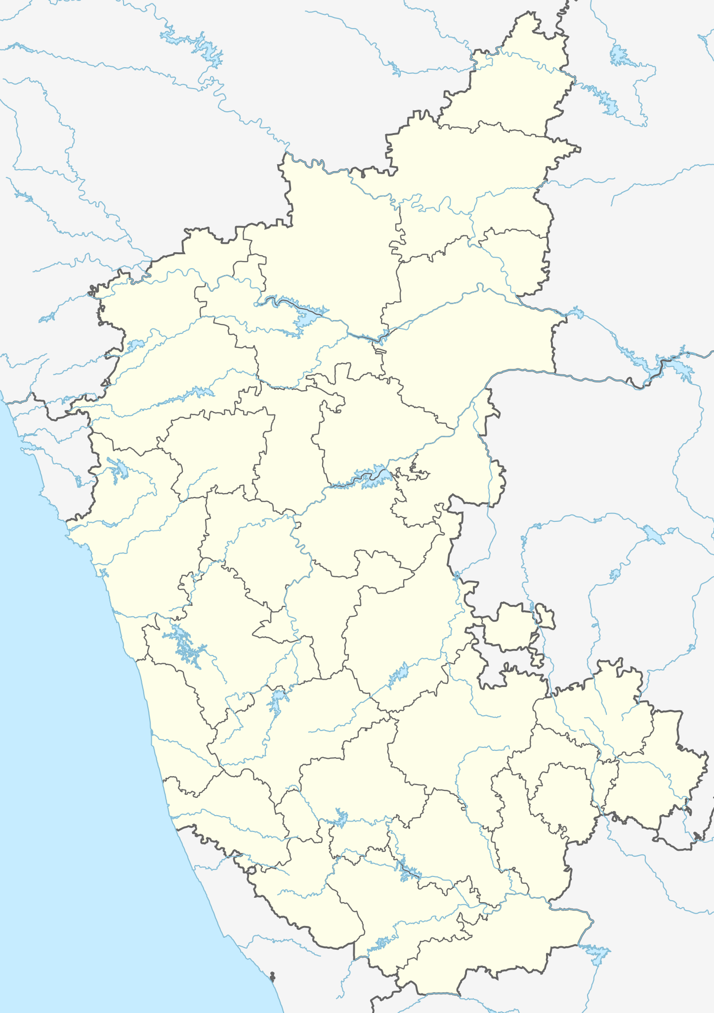
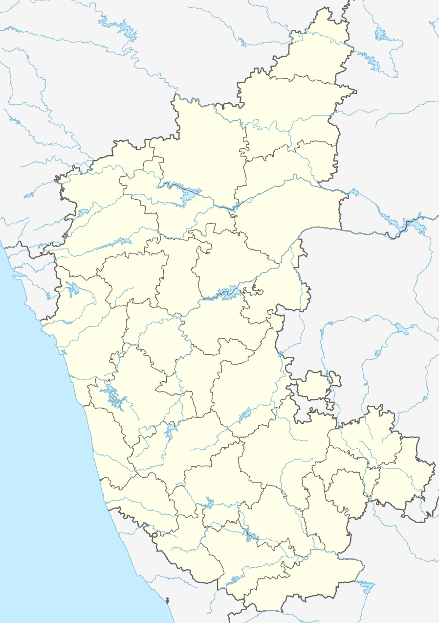
Location map of Karnataka Geographic limits of the map:
|
| Date | (UTC) |
| Source | |
| Author |
|
| Other versions |
Derivative works of this file: |
| This is a retouched picture, which means that it has been digitally altered from its original version. Modifications: Created 3 new districts Chikkaballapur, Ramanagara and Yadgir. Changed conventions per WP:WPMAP. The original can be viewed here: Karnataka locator map.svg:
|
This file is licensed under the Creative Commons Attribution-Share Alike 3.0 Unported license.
- You are free:
- to share – to copy, distribute and transmit the work
- to remix – to adapt the work
- Under the following conditions:
- attribution – You must give appropriate credit, provide a link to the license, and indicate if changes were made. You may do so in any reasonable manner, but not in any way that suggests the licensor endorses you or your use.
- share alike – If you remix, transform, or build upon the material, you must distribute your contributions under the same or compatible license as the original.
Original upload log[edit]
This image is a derivative work of the following images:
- File:Karnataka_locator_map.svg licensed with Cc-by-sa-3.0
- 2007-05-06T13:55:02Z Planemad 1630x2356 (231773 Bytes) {{WikiProject_India_Maps |Title=Karnataka locator Map |Description=Map of [[w:Karnataka]] with road and rail lines |Source= [http://aquarium.lipetsk.ru/discovery/India2004/karnataka-map.jpg Karnataka Map], [http://www.indianr
Uploaded with derivativeFX
File history
Click on a date/time to view the file as it appeared at that time.
| Date/Time | Thumbnail | Dimensions | User | Comment | |
|---|---|---|---|---|---|
| current | 03:10, 16 June 2023 | | 898 × 1,273 (759 KB) | C1MM (talk | contribs) | c Vijayanagara district |
| 04:41, 13 August 2021 |  | 851 × 1,211 (582 KB) | C1MM (talk | contribs) | Added more rivers | |
| 03:33, 16 July 2021 |  | 851 × 1,211 (561 KB) | C1MM (talk | contribs) | Added more accurate district boundaries | |
| 23:41, 14 December 2020 |  | 1,634 × 2,367 (341 KB) | C1MM (talk | contribs) | Fixed boundaries of Vijayanagara district | |
| 22:10, 14 December 2020 |  | 1,634 × 2,367 (345 KB) | C1MM (talk | contribs) | Added boundaries of AP/Telangana and rivers | |
| 19:26, 13 December 2020 |  | 1,634 × 2,367 (342 KB) | C1MM (talk | contribs) | Fixed district boundaries of Ballari and added Vijayanagara district | |
| 03:53, 21 April 2020 |  | 1,634 × 2,367 (289 KB) | C1MM (talk | contribs) | Added rivers | |
| 15:50, 15 November 2010 |  | 1,630 × 2,356 (207 KB) | Nayvik (talk | contribs) | Changed background color | |
| 15:34, 15 November 2010 |  | 1,630 × 2,356 (206 KB) | Nayvik (talk | contribs) | {{Information |Description=Location map of Karnataka Geographic limits of the map: * 18.5°N * 11.0°N * 73.6°E * 78.7°E |Source=*File:Karnataka_locator_map.svg, [http://www.censusindia.gov.in/2011-Images/ADMINI2011.jpg Census In |
You cannot overwrite this file.
File usage on Commons
The following 78 pages use this file:
- Karnataka
- File:Districts affected by Sept 2008 Hindu-Christian conflict.svg
- File:India Karnataka COVID-19 map.png
- File:India Karnataka COVID-19 map.svg
- File:Karnataka Bangalore Rural locator map.svg
- File:Karnataka Bangalore Urban locator map.svg
- File:Karnataka Belgaum locator map.svg
- File:Karnataka Bellary locator map.svg
- File:Karnataka Bidar locator map.svg
- File:Karnataka Bijapur locator map.svg
- File:Karnataka Chamarajanagar locator map.svg
- File:Karnataka Chikballapur locator map.svg
- File:Karnataka Chikmagalur locator map.svg
- File:Karnataka Chitradurga locator map.svg
- File:Karnataka DK locator map.svg
- File:Karnataka Davanagere locator map.svg
- File:Karnataka Dharwad locator map.svg
- File:Karnataka Gadag locator map.svg
- File:Karnataka Gulbarga locator map.svg
- File:Karnataka Hassan locator.svg
- File:Karnataka Haveri locator map.svg
- File:Karnataka Kodagu locator map.svg
- File:Karnataka Kolar locator map.svg
- File:Karnataka Koppal locator map.svg
- File:Karnataka Mandya locator map.svg
- File:Karnataka Mysore locator map.svg
- File:Karnataka Raichur locator map.svg
- File:Karnataka Ramanagara locator map.svg
- File:Karnataka Shimoga locator map.svg
- File:Karnataka State Highway 5.svg
- File:Karnataka Tumkur locator map.svg
- File:Karnataka UK locator map.svg
- File:Karnataka Udupi locator map.svg
- File:Karnataka Yadgir locator map.svg
- File:Karnataka divisions.svg
- Category:Airports in Karnataka
- Category:Archaeological sites in Karnataka
- Category:Bodies of water in Karnataka
- Category:Bridges in Karnataka
- Category:Buddhism in Karnataka
- Category:Buddhist temples in Karnataka
- Category:Bus stations in Karnataka
- Category:Dams in Karnataka
- Category:Deaths in Karnataka
- Category:Disasters and accidents in Karnataka
- Category:Engineers from Karnataka
- Category:Festivals of Karnataka
- Category:Film directors from Karnataka
- Category:Flora of Karnataka
- Category:Forts in Karnataka
- Category:Hill stations in Karnataka
- Category:Hills of Karnataka
- Category:Hindu temples in Karnataka
- Category:Hospitals in Karnataka
- Category:Jain temples in Karnataka
- Category:Karnataka
- Category:Lakes of Karnataka
- Category:Maps of Karnataka
- Category:Mountains of Karnataka
- Category:Municipal corporations in Karnataka
- Category:Museums in Karnataka
- Category:Newspapers of Karnataka
- Category:Palaces in Karnataka
- Category:People of Karnataka
- Category:Populated places in Karnataka
- Category:Postcards of Karnataka
- Category:Power plants in Karnataka
- Category:Rail transport in Karnataka
- Category:Railway junction stations in Karnataka
- Category:Railway stations in Karnataka
- Category:Reservoirs in Karnataka
- Category:Rivers of Karnataka
- Category:Roads in Karnataka
- Category:Screenwriters from Karnataka
- Category:Shiva temples in Karnataka
- Category:Temples in Karnataka
- Category:Visitor attractions in Karnataka
- Category:Waterfalls in Karnataka
File usage on other wikis
The following other wikis use this file:
- Usage on ar.wikipedia.org
- Usage on as.wikipedia.org
- Usage on azb.wikipedia.org
- تومکور
- بنقلور
- عباسی، کارناتاکا
- اودقولام
- پیکلیهال
- اوداجی (هیندوستان)
- اوچیلا, اودوپی دیستریکت
- اوچاواد
- او خاناپور
- ویراهانوماکاناپالیا
- فاجیر (هیندوستان)
- پتالور (هیندوستان)
- پت آماپور
- ویراکامبا
- ویراپور
- وانور (هیندوستان)
- ساتیجری
- ساتانور, ماقادی
- ساتانور, بانقالور
- ساسالاتی
- سارقور
- ساراواد
- ساراپادی
- ساپتاساقار
- سانتور
- سانتکاسالاجر
- مایاکوندا
- ساناتی
- ماویناکر
- ماوالی
- ماتیواد
- کالادکا
- سانیکاتا
- کالکونت
- کالکری
- ماتماری
- سانقاناهالا
- کالجی (هیندوستان)
- سانقامشوارا, کالاقاتاجی
- ماتاداکوروباراهاتی
- ماستیهولی
- کالاسا, کوندقول
- ماسارکال
- ماسابینال
View more global usage of this file.