File:RangeMap-PlainsZebra.GIF
Jump to navigation
Jump to search
No higher resolution available.
RangeMap-PlainsZebra.GIF (341 × 341 pixels, file size: 9 KB, MIME type: image/gif)
Captions
Captions
Add a one-line explanation of what this file represents
Summary[edit]
| Description | Range Map Plains Zebra. |
| Source | Moelman, P.D. 2002. Equids. Zebras, Assess and Horses. Status Survey and Conservation Action Plan. IUCN/SSC Equid Specialist Group. IUCN, Gland, Switzerland. |
| Author | Peter Maas |
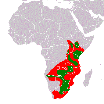
Range Map Plains Zebra. Historical range: Red. Present range: Green. Based on maps in "Moelman, P.D. 2002. Equids. Zebras, Assess and Horses. Status Survey and Conservation Action Plan. IUCN/SSC Equid Specialist Group. IUCN, Gland, Switzerland." (http://www.iucn.org/themes/ssc/pubs/sscaps.htm#Equids2002 archive copy at the Wayback Machine). Author: Peter Maas 11:15, 6 April 2006 (UTC)
Licensing[edit]

|
Permission is granted to copy, distribute and/or modify this document under the terms of the GNU Free Documentation License, Version 1.2 or any later version published by the Free Software Foundation; with no Invariant Sections, no Front-Cover Texts, and no Back-Cover Texts. A copy of the license is included in the section entitled GNU Free Documentation License. |
| This file is licensed under the Creative Commons Attribution-Share Alike 3.0 Unported license. | ||
| ||
| This licensing tag was added to this file as part of the GFDL licensing update. |
derivative works[edit]
Derivative works of this file: RangeMap-PlainsZebra.svg
File history
Click on a date/time to view the file as it appeared at that time.
| Date/Time | Thumbnail | Dimensions | User | Comment | |
|---|---|---|---|---|---|
| current | 23:46, 8 March 2018 | | 341 × 341 (9 KB) | Maphobbyist (talk | contribs) | South Sudan border |
| 11:30, 6 April 2006 |  | 341 × 341 (6 KB) | Pmaas (talk | contribs) | Range Map Plains Zebra. Historical range: Red. Present range: Green. Based on maps in "Duncan, P. (ed.). 1992. Zebras, Asses, and Horses: an Action Plan for the Conservation of Wild Equids. IUCN/SSC Equid Specialist Group. IUCN, Gland, Switzerland". Autho | |
| 11:15, 6 April 2006 |  | 341 × 341 (6 KB) | Pmaas (talk | contribs) | Range Map Plains Zebra. Historical range: Red. Present range: Green. Based on maps in "Duncan, P. (ed.). 1992. Zebras, Asses, and Horses: an Action Plan for the Conservation of Wild Equids. IUCN/SSC Equid Specialist Group. IUCN, Gland, Switzerland". Aut |
You cannot overwrite this file.
File usage on Commons
The following 2 pages use this file:
File usage on other wikis
The following other wikis use this file:
- Usage on br.wikipedia.org
- Usage on fi.wikipedia.org
- Usage on hr.wikipedia.org
- Usage on lv.wikipedia.org
- Usage on nl.wikipedia.org
- Usage on oc.wikipedia.org
- Usage on pl.wikipedia.org
- Usage on pt.wikipedia.org
- Usage on ru.wikipedia.org
- Usage on sh.wikipedia.org
- Usage on sk.wikipedia.org
- Usage on sr.wikipedia.org
- Usage on tr.wikipedia.org
- Usage on zh.wikipedia.org