File:Global tree canopy map NASA.jpg
Jump to navigation
Jump to search

Size of this preview: 800 × 351 pixels. Other resolutions: 320 × 140 pixels | 640 × 281 pixels | 1,024 × 449 pixels | 1,280 × 561 pixels | 2,560 × 1,122 pixels | 7,920 × 3,472 pixels.
Original file (7,920 × 3,472 pixels, file size: 3.67 MB, MIME type: image/jpeg)
Captions
Captions
Add a one-line explanation of what this file represents
Summary[edit]
| Description |
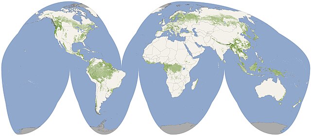
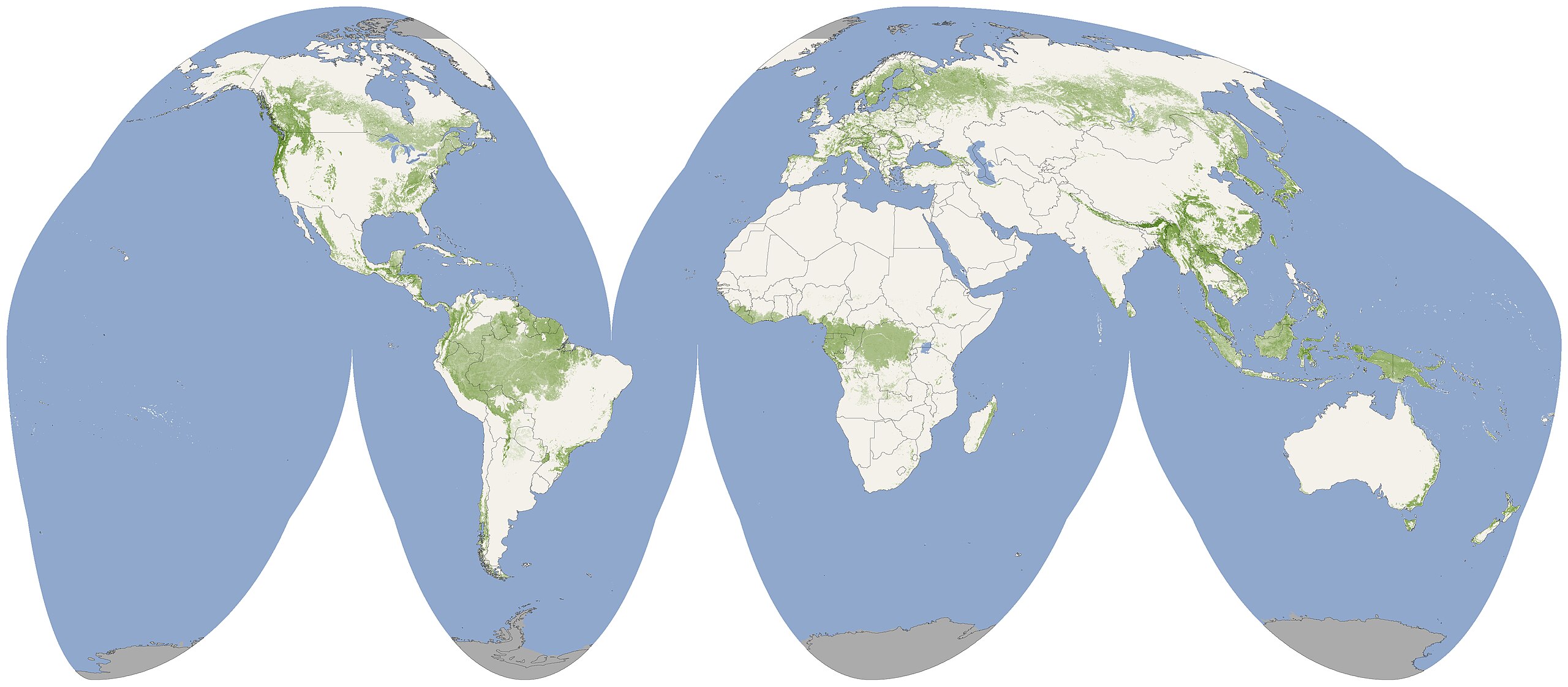
English: A first-of-its-kind global map shows forest canopy height in shades of green from 0 to 70 meters (230 feet). For any patch of forest, the height shown means that 90 percent or more of the trees in the patch are that tall or taller. Created from data taken by NASA satellites ICESat, Terra and Aqua.
Polski: Pierwsza globalna mapa wysokości drzewostanu. Kolor piksela powiązany jest z wysokością drzewostanu, oznaczając, że 90% drzew na danym obszarze ma wysokość większą lub równej od przypisanej danemu odcieniowi.
Mapa stworzona w oparciu o dane zebrane przez satelity NASA: ICESat, Terra i Aqua. |
| Date | |
| Source | http://www.nasa.gov/topics/earth/features/forest-height-map.html |
| Author | NASA Earth Observatory/Image by Jesse Allen and Robert Simmon/Based on data from Michael Lefsky |
Licensing[edit]
| This file is in the public domain in the United States because it was solely created by NASA. NASA copyright policy states that "NASA material is not protected by copyright unless noted". (See Template:PD-USGov, NASA copyright policy page or JPL Image Use Policy.) | ||
 |
Warnings:
|
File history
Click on a date/time to view the file as it appeared at that time.
| Date/Time | Thumbnail | Dimensions | User | Comment | |
|---|---|---|---|---|---|
| current | 00:01, 12 October 2010 | | 7,920 × 3,472 (3.67 MB) | LobStoR (talk | contribs) | from original upload: lossless crop, baseline JPEG to avoid MediaWiki thumbnail issues |
| 00:17, 26 July 2010 |  | 8,013 × 3,476 (4.14 MB) | Saibo (talk | contribs) | from orig: cropped white, saved as jpg 97 Q. using GIMP | |
| 10:17, 25 July 2010 |  | 8,259 × 3,943 (4.68 MB) | MPF (talk | contribs) | crop excess white surround | |
| 08:49, 24 July 2010 |  | 8,641 × 6,013 (3.47 MB) | NH2501 (talk | contribs) | {{Information |Description={{en|1=A first-of-its-kind global map shows forest canopy height in shades of green from 0 to 70 meters (230 feet). For any patch of forest, the height shown means that 90 percent or more of the trees in the patch are that tall |
You cannot overwrite this file.
File usage on Commons
There are no pages that use this file.
File usage on other wikis
The following other wikis use this file:
- Usage on lt.wikipedia.org
- Usage on pl.wikinews.org