File:Gegenwärtiges Kerngebiet der kurdischen Siedlungsgebiete.jpg
Jump to navigation
Jump to search

Size of this preview: 800 × 583 pixels. Other resolutions: 320 × 233 pixels | 640 × 466 pixels | 1,024 × 746 pixels | 1,400 × 1,020 pixels.
Original file (1,400 × 1,020 pixels, file size: 843 KB, MIME type: image/jpeg)
Captions
Captions
Add a one-line explanation of what this file represents
Summary

| Description |
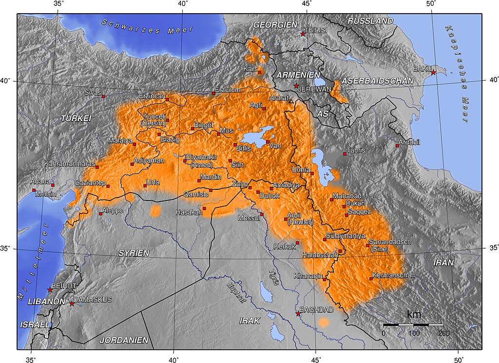
Deutsch: Gegenwärtiges Kerngebiet der kurdischen Siedlungsgebiete |
| Date | 11 July 2005 (original upload date) |
| Source |
|
| Author | The original uploader was Captain Blood at German Wikipedia. |
Licensing

|
Permission is granted to copy, distribute and/or modify this document under the terms of the GNU Free Documentation License, Version 1.2 or any later version published by the Free Software Foundation; with no Invariant Sections, no Front-Cover Texts, and no Back-Cover Texts. A copy of the license is included in the section entitled GNU Free Documentation License. |
| This file is licensed under the Creative Commons Attribution-Share Alike 3.0 Unported license. | ||
| ||
| This licensing tag was added to this file as part of the GFDL licensing update. |
Original upload log
The original description page was here. All following user names refer to de.wikipedia.
- 2005-10-12 12:06 Captain Blood 1400×1020×8 (571103 bytes) Ergänzungen
- 2005-07-13 18:35 Captain Blood 1400×1020×8 (563930 bytes)
- 2005-07-12 22:22 KureCewlik81 1400×1020×8 (278544 bytes)
- 2005-07-12 14:12 Captain Blood 1400×1020×8 (468797 bytes)
- 2005-07-11 16:26 Captain Blood 1400×1020×8 (464501 bytes) {{Bild-GFDL-GMT}}
File history
Click on a date/time to view the file as it appeared at that time.
| Date/Time | Thumbnail | Dimensions | User | Comment | |
|---|---|---|---|---|---|
| current | 22:31, 6 May 2016 | | 1,400 × 1,020 (843 KB) | Masoud bukani (talk | contribs) | Bukan in iranian kurdistan added ! city population: 200,000 - Mahabad pop: 165,000 and Saqqez: 150,000 |
| 01:44, 4 November 2014 |  | 1,400 × 1,020 (490 KB) | Saman bokan72 (talk | contribs) | کوردستان | |
| 08:57, 16 October 2014 |  | 1,400 × 1,020 (558 KB) | Denniss (talk | contribs) | Reverted to version as of 07:22, 2 March 2011 | |
| 22:47, 15 October 2014 |  | 1,400 × 1,020 (490 KB) | Saman bokan72 (talk | contribs) | کوردستانی گەورە | |
| 07:22, 2 March 2011 |  | 1,400 × 1,020 (558 KB) | Parsumash (talk | contribs) | Reverted to version as of 20:47, 23 February 2008 | |
| 22:59, 5 August 2010 |  | 1,400 × 1,020 (315 KB) | Saadwand (talk | contribs) | minore | |
| 17:32, 26 July 2010 |  | 1,400 × 1,020 (286 KB) | Saadwand (talk | contribs) | minor changes in south of kurdish inhabited area. | |
| 20:47, 23 February 2008 |  | 1,400 × 1,020 (558 KB) | Cocoloi (talk | contribs) | {{Information |Description={{de|Gegenwärtiges Kerngebiet der kurdischen Siedlungsgebiete| | Bei der Erstellung der Landkarte wurden die '''Generic Mapping Tools''' verwendet: http://gmt.soest.hawaii.edu/ Für das Relief - falls vorhanden - wurde(n) ein |
You cannot overwrite this file.
File usage on Commons
The following 5 pages use this file:
File usage on other wikis
The following other wikis use this file:
- Usage on bg.wikipedia.org
- Usage on ckb.wikipedia.org
- بەکارھێنەر:Cyrus abdi~ckbwiki
- بەکارھێنەر:ئاسۆ
- بەکارھێنەر:Broosk
- بەکارھێنەر:Barham
- بەکارھێنەر:Calak
- داڕێژە:بەکارھێنەر سەربەخۆیی کوردستان
- دەروازە:کوردستان/کۆن
- داڕێژە:مێژووی کوردستان
- بەکارھێنەر:Diyar se
- بەکارھێنەر:Baneh k
- داڕێژە:ویکیپرۆژەی جوگرافیای کوردستان
- داڕێژە:بەکارھێنەر ویکیپرۆژەی جوگرافیای کوردستان
- بەکارھێنەر:Eroe
- بەکارھێنەر:Arez pro
- بەکارھێنەر:Diyako kazm/ئەزموون
- بەکارھێنەر:Mudric
- پۆل:ئەندامانی ویکیپرۆژەی جوگرافیای کوردستان
- بەکارھێنەر:Ku&Kurdistan
- بەکارھێنەر:کوردی کوردستان
- بەکارھێنەر:Diyako kazm
- بەکارھێنەر:Phraortes~ckbwiki
- بەکارھێنەر:Sorou6sh
- بەکارھێنەر:Rauf t jabar
- بەکارھێنەر:Ismail.Sharifi
- بەکارھێنەر:Rebin galaly
- بەکارھێنەر:Yahya yasa
- بەکارھێنەر:Ibrahim aziz
- بەکارھێنەر:Zanear alves
- بەکارھێنەر:Rebin Sami
- بەکارھێنەر:محمد ناصح
- پێڕستی شارەکانی کوردستان
- بەکارھێنەر:مامۆستا
- بەکارھێنەر:ئیلامی
- بەکارھێنەر:GoRaN909
- بەکارھێنەر:Oneplusoneequalsone
- بەکارھێنەر:Aboutkurdishcinema
- بەکارھێنەر:Mamozk
- Usage on de.wikipedia.org
- Usage on diq.wikipedia.org
- Usage on en.wikipedia.org
- Usage on es.wiktionary.org
- Usage on fa.wikipedia.org
View more global usage of this file.