File:Via Appia map.jpg
Jump to navigation
Jump to search

Size of this preview: 800 × 433 pixels. Other resolutions: 320 × 173 pixels | 640 × 346 pixels | 1,280 × 692 pixels.
Original file (1,280 × 692 pixels, file size: 599 KB, MIME type: image/jpeg)
Captions
Captions
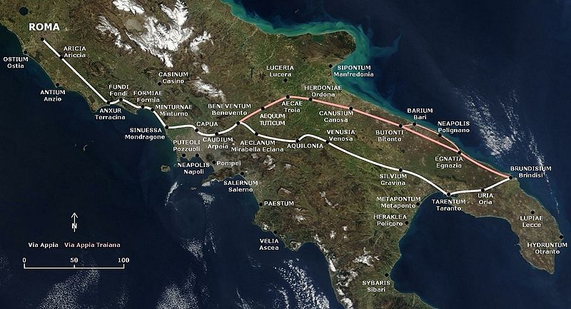
Via Appia (white) and Via Traiana (red), Italy

English: Map of the Appian Way and the later and shorter Via Appia Traiana.
Deutsch: Karte der Via Appia und der Via Appia Traiana.
Summary[edit]
This map is based on the following picture: Image:Satellite image of Italy in March 2003.jpg
Licensing[edit]
| I, the copyright holder of this work, release this work into the public domain. This applies worldwide. In some countries this may not be legally possible; if so: I grant anyone the right to use this work for any purpose, without any conditions, unless such conditions are required by law. |
| This file is in the public domain in the United States because it was solely created by NASA. NASA copyright policy states that "NASA material is not protected by copyright unless noted". (See Template:PD-USGov, NASA copyright policy page or JPL Image Use Policy.) | ||
 |
Warnings:
|
File history
Click on a date/time to view the file as it appeared at that time.
| Date/Time | Thumbnail | Dimensions | User | Comment | |
|---|---|---|---|---|---|
| current | 17:19, 9 November 2009 | | 1,280 × 692 (599 KB) | AlMare (talk | contribs) | Mondragone |
| 16:22, 27 July 2009 |  | 1,280 × 692 (602 KB) | AlMare (talk | contribs) | +Aequum Tuticum | |
| 18:02, 14 February 2009 |  | 1,280 × 692 (538 KB) | AlMare (talk | contribs) | Reverted to version as of 17:31, 13 July 2006 | |
| 21:03, 1 December 2008 |  | 1,280 × 692 (603 KB) | AlMare (talk | contribs) | +Sessa Aurunca | |
| 17:31, 13 July 2006 |  | 1,280 × 692 (538 KB) | AlMare (talk | contribs) | == Summary == This map is based on the following picture: Image:Satellite image of Italy in March 2003.jpg == Licensing == {{PD-self}} | |
| 17:26, 13 July 2006 |  | 1,000 × 433 (357 KB) | AlMare (talk | contribs) | This map is based on the following picture: Image:Satellite image of Italy in March 2003.jpg) |
&action=edit&redlink=1)
You cannot overwrite this file.
File usage on Commons
The following 6 pages use this file:
File usage on other wikis
The following other wikis use this file:
- Usage on af.wikipedia.org
- Usage on ar.wikipedia.org
- Usage on azb.wikipedia.org
- Usage on be.wikipedia.org
- Usage on bg.wikipedia.org
- Usage on bn.wikipedia.org
- Usage on ca.wikipedia.org
- Usage on cs.wikipedia.org
- Usage on de.wikipedia.org
- Usage on el.wikipedia.org
- Usage on en.wikipedia.org
- Usage on en.wikivoyage.org
- Usage on eo.wikipedia.org
- Usage on es.wikipedia.org
- Usage on et.wikipedia.org
- Usage on fr.wikipedia.org
- Usage on he.wikipedia.org
- Usage on hr.wikipedia.org
- Usage on hu.wikipedia.org
- Usage on id.wikipedia.org
- Usage on it.wikipedia.org
View more global usage of this file.