File:SatavahanaMap.jpg
Jump to navigation
Jump to search

Size of this preview: 467 × 599 pixels. Other resolutions: 187 × 240 pixels | 374 × 480 pixels | 599 × 768 pixels | 1,123 × 1,440 pixels.
Original file (1,123 × 1,440 pixels, file size: 327 KB, MIME type: image/jpeg)
Captions
Captions
Add a one-line explanation of what this file represents

|
This map has been uploaded by Electionworld from en.wikipedia.org to enable the |

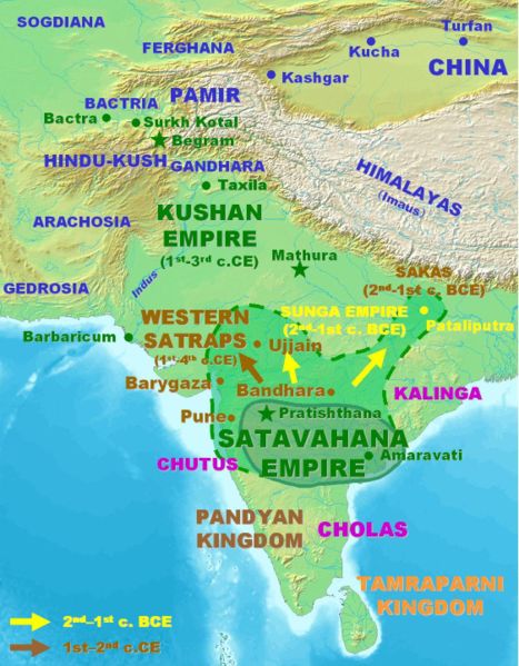
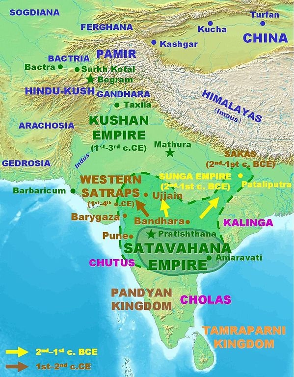
Approximate extent of the Satavahana Empire.
Personal map, 2005. Released in the Public Domain.
| This work has been released into the public domain by its author, PHG. This applies worldwide. In some countries this may not be legally possible; if so: |
File history
Click on a date/time to view the file as it appeared at that time.
| Date/Time | Thumbnail | Dimensions | User | Comment | |
|---|---|---|---|---|---|
| current | 14:09, 18 March 2007 | | 1,123 × 1,440 (327 KB) | World Imaging (talk | contribs) | Better map, personal creation. |
| 23:21, 13 December 2006 |  | 395 × 432 (29 KB) | Electionworld (talk | contribs) | {{ew|en|PHG}} {{POV-map}} Approximate extent of the Satavahana Empire. Personal map, 2005. Released in the Public Domain. {{pd}} |
You cannot overwrite this file.
File usage on Commons
The following 2 pages use this file:
File usage on other wikis
The following other wikis use this file:
- Usage on ba.wikipedia.org
- Usage on bn.wikipedia.org
- Usage on ca.wikipedia.org
- Usage on cs.wikipedia.org
- Usage on cv.wikipedia.org
- Usage on de.wikipedia.org
- Usage on en.wikipedia.org
- Usage on es.wikipedia.org
- Usage on eu.wikipedia.org
- Usage on fa.wikipedia.org
- Usage on fi.wikipedia.org
- Usage on fr.wikipedia.org
- Usage on hi.wikipedia.org
- Usage on hy.wikipedia.org
- Usage on id.wikipedia.org
- Usage on id.wikibooks.org
- Usage on it.wikipedia.org
- Usage on kn.wikipedia.org
- Usage on ko.wikipedia.org
- Usage on lt.wikipedia.org
- Usage on mr.wikipedia.org
- Usage on nl.wikipedia.org
- Usage on pnb.wikipedia.org
- Usage on ru.wikipedia.org
- Usage on sa.wikipedia.org
- Usage on sh.wikipedia.org
- Usage on si.wikipedia.org
- Usage on sq.wikipedia.org
- Usage on sr.wikipedia.org
- Usage on te.wikipedia.org
- Usage on th.wikipedia.org
- Usage on tl.wikipedia.org
- Usage on tt.wikipedia.org
- Usage on uk.wikipedia.org
- Usage on ur.wikipedia.org
View more global usage of this file.