File:Naajaat panorama 2007-08-09 2 cropped USM downsampled.jpg
Jump to navigation
Jump to search
Size of this preview: 800 × 172 pixels. Other resolutions: 320 × 69 pixels | 640 × 138 pixels | 1,024 × 220 pixels | 1,280 × 275 pixels | 5,224 × 1,124 pixels.
Original file (5,224 × 1,124 pixels, file size: 6.36 MB, MIME type: image/jpeg)
Captions
Captions
Add a one-line explanation of what this file represents
Summary[edit]
| Description |
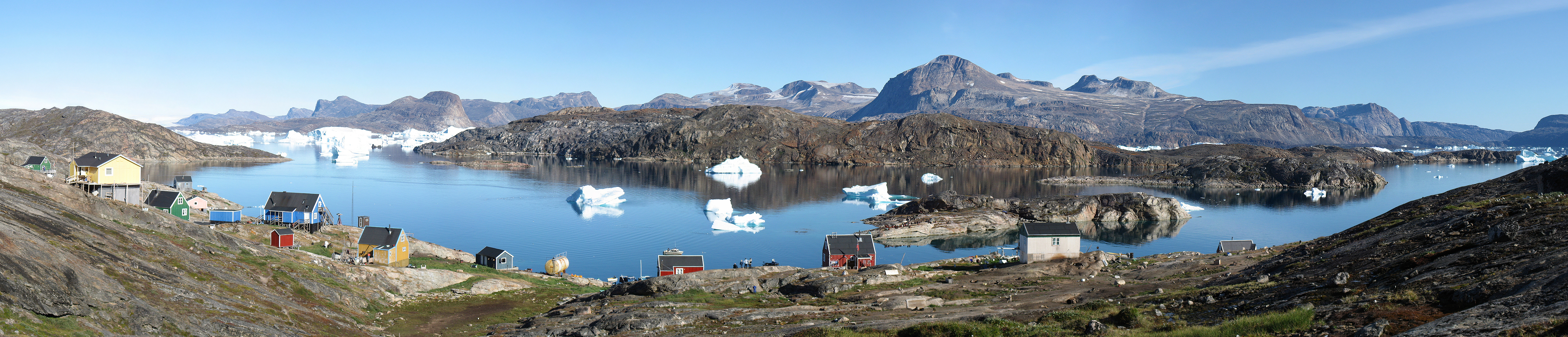
Dansk: Panorama ud over den lille nordvestgrønlandske bydg Naajaat. I baggrunden til venstre ses den grønlandske indlandsis. Panoramaet er skabt ud fra håndholdte billeder taget med et Canon IXUS 800 IS kompaktkamera. Sammenhæftning er udført i PTGui med Smartblend.
English: Panorama of the small settlement Naajaat in North-West Greenland. The Greenland ice sheet is seen to the upper left. The panoramic is based on hand-held photos taken with a Canon IXUS 800 IS compact camera. The stiching was done in PTGui with Smartblend.
Français : Le village de Naajaat dans le Nord-Ouest du Groenland. On peut voir la calotte glaciaire en haut à gauche. Image panoramique obtenue à partir de photos réalisées avec un appareil photo digital compact Canon IXUS 800 IS. |
| Date | |
| Source |
Based on |
| Author | Original photos by Kim Hansen, stitched by Noodle snacks |
| Other versions | Derivative works of this file: Naajaat panorama 2007-08-09 2 cropped USM downsampled edit.jpg |


| Camera location | | View this and other nearby images on: OpenStreetMap |
|---|
Licensing[edit]
I, the copyright holder of this work, hereby publish it under the following licenses:

|
Permission is granted to copy, distribute and/or modify this document under the terms of the GNU Free Documentation License, Version 1.2 or any later version published by the Free Software Foundation; with no Invariant Sections, no Front-Cover Texts, and no Back-Cover Texts. A copy of the license is included in the section entitled GNU Free Documentation License. |
This file is licensed under the Creative Commons Attribution-Share Alike 4.0 International, 3.0 Unported, 2.5 Generic, 2.0 Generic and 1.0 Generic license.
- You are free:
- to share – to copy, distribute and transmit the work
- to remix – to adapt the work
- Under the following conditions:
- attribution – You must give appropriate credit, provide a link to the license, and indicate if changes were made. You may do so in any reasonable manner, but not in any way that suggests the licensor endorses you or your use.
- share alike – If you remix, transform, or build upon the material, you must distribute your contributions under the same or compatible license as the original.
You may select the license of your choice.

|
This image has been assessed under the valued image criteria and is considered the most valued image on Commons within the scope: Naajaat. You can see its nomination here. |
| Annotations | This image is annotated: View the annotations at Commons |
File history
Click on a date/time to view the file as it appeared at that time.
| Date/Time | Thumbnail | Dimensions | User | Comment | |
|---|---|---|---|---|---|
| current | 01:17, 27 February 2010 | 5,224 × 1,124 (6.36 MB) | JJ Harrison (talk | contribs) | selective sharpen a spot. | |
| 01:15, 27 February 2010 | 5,224 × 1,124 (6.36 MB) | JJ Harrison (talk | contribs) | restitch | ||
| 22:05, 21 December 2007 | 5,900 × 1,200 (1.99 MB) | Slaunger (talk | contribs) | {{Information |Description= {{da|Panorama ud over den lille nordvestgrønlandske bydg Naajaat. I baggrunden til venstre ses indlandsisen.}} {{en|Panorama of the small settlement Naajaat in North-West Greenland. The ice cap is |
You cannot overwrite this file.
File usage on Commons
The following 24 pages use this file:
- Grønland - Kalaallit Nunaat
- User:Slaunger/Greenland
- User:Slaunger/Greenland/Towns and settlements
- User talk:Herbythyme/Arc16
- User talk:JJ Harrison
- User talk:Slaunger/Archives/FPC
- User talk:Slaunger/Archives/VIC
- Commons:Featured picture candidates/File:Naajaat panorama 2007-08-09 2 cropped USM downsampled.jpg
- Commons:Featured picture candidates/Log/March 2010
- Commons:Featured pictures/chronological/2010-A
- Commons:Picture of the Year/2010/Galleries/2010-A
- Commons:Picture of the Year/2010/Galleries/All
- Commons:Picture of the Year/2010/Galleries/Index/Panoramas
- Commons:Picture of the Year/2010/Galleries/Table
- Commons:Picture of the Year/2010/Galleries/Table/03
- Commons:Picture of the Year/2010/Results/R1/ALL/Table
- Commons:Picture of the Year/2010/Results/R1/Panoramas
- Commons:Picture of the Year/2010/Results/R1/Panoramas/Table
- Commons:Valued image candidates/Naajaat panorama 2007-08-09 2 cropped USM downsampled.jpg
- Commons:Valued images by topic/Places/Cities and towns
- Commons talk:Picture of the Year/2010/Galleries/Table
- Commons talk:Picture of the Year/2010/Results/R1/ALL/Table
- File:Greenland Wikivoyage banner.jpg
- File:Naajaat panorama 2007-08-09 2 cropped USM downsampled edit.jpg
File usage on other wikis
The following other wikis use this file:
- Usage on ast.wikipedia.org
- Usage on azb.wikipedia.org
- Usage on da.wikipedia.org
- Usage on en.wikipedia.org
- Usage on eo.wikipedia.org
- Usage on es.wikipedia.org
- Usage on fr.wikipedia.org
- Usage on it.wikipedia.org
- Usage on kl.wikipedia.org
- Usage on nl.wikipedia.org
- Usage on no.wikipedia.org
- Usage on pt.wikipedia.org
- Usage on ro.wikipedia.org
- Usage on ru.wikipedia.org
- Usage on stq.wikipedia.org
- Usage on sv.wikipedia.org
- Usage on vi.wikipedia.org