File:Map-Nauru-Second World-War-fr.png
Jump to navigation
Jump to search

Size of this preview: 780 × 600 pixels. Other resolutions: 312 × 240 pixels | 624 × 480 pixels | 999 × 768 pixels | 1,280 × 984 pixels | 2,560 × 1,969 pixels | 3,296 × 2,535 pixels.
Original file (3,296 × 2,535 pixels, file size: 712 KB, MIME type: image/png)
Captions
Captions
Add a one-line explanation of what this file represents

|
This military map image could be re-created using vector graphics as an SVG file. This has several advantages; see Commons:Media for cleanup for more information. If an SVG form of this image is available, please upload it and afterwards replace this template with
{{vector version available|new image name}}.
It is recommended to name the SVG file “Map-Nauru-Second World-War-fr.svg”—then the template Vector version available (or Vva) does not need the new image name parameter. |
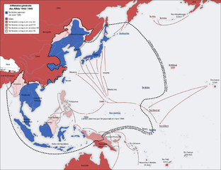
| Description | Situation of Nauru during the 1943-45 allies afensive. Modification of Image:Second world war asia 1943-1945 map fr-1.png |
| Source | Map drawn by , San Jose 26. April 2005 based on the maps of the University of Texas Libraries |
| Author | Kimdime69 |

|
Permission is granted to copy, distribute and/or modify this document under the terms of the GNU Free Documentation License, Version 1.2 or any later version published by the Free Software Foundation; with no Invariant Sections, no Front-Cover Texts, and no Back-Cover Texts. A copy of the license is included in the section entitled GNU Free Documentation License. |
| This file is licensed under the Creative Commons Attribution-Share Alike 3.0 Unported license. | ||
| ||
| This licensing tag was added to this file as part of the GFDL licensing update. |
Over versions[edit]
A French version is available: Image:Second world war asia 1943-1945 map fr-1.png
File history
Click on a date/time to view the file as it appeared at that time.
| Date/Time | Thumbnail | Dimensions | User | Comment | |
|---|---|---|---|---|---|
| current | 07:51, 21 January 2007 | | 3,296 × 2,535 (712 KB) | Kimdime (talk | contribs) | |
| 01:20, 21 January 2007 |  | 3,296 × 2,535 (733 KB) | Kimdime (talk | contribs) | ||
| 00:46, 21 January 2007 |  | 3,296 × 2,535 (712 KB) | Kimdime (talk | contribs) | {{Information |Description=Situation of Nauru during the 1943-45 allies afensive |Source= |Date= |Author= {{u|Kimdime69}} |Permission= |other_versions= }} |
You cannot overwrite this file.
File usage on Commons
There are no pages that use this file.
File usage on other wikis
The following other wikis use this file:
- Usage on ba.wikipedia.org
- Usage on fr.wikipedia.org
- Usage on ka.wikipedia.org
- Usage on pl.wikipedia.org
- Usage on ru.wikipedia.org
- Usage on uk.wikipedia.org