Rhode Island
71°30′W / 41.7°N 71.5°W / 41.7; -71.5
Rhode Island is a state in the New Ingland region o the Unitit States. It is the smawest state in aurie, the seivent least populous, an is the seicont maist densely populatit. It haes the langest offeecial name o ony state. Rhode Island is mairchit bi Connecticut tae the west, Massachusetts tae the north an east, an the Atlantic Ocean tae the sooth via Rhode Island Soond an Block Island Soond. It an aw shares a smaw maritime border wi New York. Providence is the state caipital an maist populous ceety in Rhode Island.
Rhode Island | |
|---|---|
| State of Rhode Island | |
| Eik-name(s): The Ocean State Little Rhody | |
| Motto(s): Hope | |
| Anthem: "Rhode Island's It for Me" | |
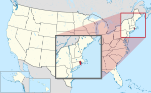
 Map o the Unitit States wi Rhode Island hielichted | |
| Kintra | Unitit States |
| Afore stateheid | Colony o Rhode Island an Providence Plantations |
| Admittit tae the Union | 29 Mey 1790 (13t) |
| Caipital (an lairgest ceety) | Providence |
| Lairgest ceety | caipital |
| Lairgest metro | Greater Providence |
| Govrenment | |
| • Govrenor | Gina Raimondo (D) |
| • Lieutenant Governor | Daniel McKee (D) |
| Legislatur | Rhode Island General Assemmly |
| • Upper hoose | Senate |
| • Lawer hoose | Hoose o Representatives |
| Judiciar | Rhode Island Supreme Coort |
| U.S. senators | Jack Reed (D) Sheldon Whitehouse (D) |
| U.S. Hoose delegation | 1: David Cicilline (D) 2: James Langevin (D) (leet) |
| Area | |
| • Total | 3,144 km2 (1,214 sq mi) |
| • Laund | 2,707 km2 (1,045 sq mi) |
| • Water | 438 km2 (169 sq mi) 13.9% |
| Area rank | 50t |
| Dimensions | |
| • Length | 77 km (48 mi) |
| • Width | 60 km (37 mi) |
| Elevation | 60 m (200 ft) |
| Highest elevation (Jerimoth Hill) | 247 m (812 ft) |
| Lowest elevation (Atlantic Ocean) | 0 m (0 ft) |
| Population (2019) | |
| • Total | 1,059,361 |
| • Rank | 44t |
| • Density | 388/km2 (1006/sq mi) |
| • Density rank | 2nt |
| • Median hooseaud income | $63870 |
| • Income rank | 16t |
| Demonym(s) | Rhode Islander |
| Leid | |
| • Offeecial leid | De jure: Nane De facto: Inglis |
| Time zone | UTC-05:00 (Eastren) |
| • Summer (DST) | UTC-04:00 (EDT) |
| USPS abbreviation | RI |
| ISO 3166 code | US-RI |
| Trad. abbreviation | R.I. |
| Latitude | 41° 09′ N tae 42° 01′ N |
| Longitude | 71° 07′ W tae 71° 53′ W |
| Website | www |
On 4 Mey 1776, the Colony o Rhode Island wis the first o the Thirteen Colonies tae renoonce its allegiance tae the Breetish Croun, an it wis the fowert amang the newly independent states tae ratifee the Airticles o Confederation on 9 Februar 1778. The state boycottit the 1787 convention that drew up the Unitit States Constitution an ineetially refuised tae ratifee it; it wis the last o the states tae dae sae on Mey 29, 1790.
Rhode Island's offeecial nickname is "The Ocean State", a reference tae the lairge bays an inlets that amoont tae aboot 14 percent o its tot aurie.
References
Freemit airtins
- State govrenment
Relatit information
 | This Unitit States-relatit airticle is a stub. Ye can help Wikipaedia bi expandin it. |
This article uses material from the Wikipedia Scots article Rhode Island, which is released under the Creative Commons Attribution-ShareAlike 3.0 license ("CC BY-SA 3.0"); additional terms may apply (view authors). Content is available unner CC BY-SA 4.0 unless itherwise notit. Images, videos and audio are available under their respective licenses.
®Wikipedia is a registered trademark of the Wiki Foundation, Inc. Wiki Scots (DUHOCTRUNGQUOC.VN) is an independent company and has no affiliation with Wiki Foundation.


