File:Toyamaken-top.JPG
Jump to navigation
Jump to search

Size of this preview: 800 × 449 pixels. Other resolutions: 320 × 180 pixels | 640 × 359 pixels | 1,024 × 575 pixels | 1,577 × 885 pixels.
Original file (1,577 × 885 pixels, file size: 522 KB, MIME type: image/jpeg)
Captions
Captions
Add a one-line explanation of what this file represents
Summary[edit]
| Description |
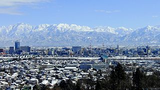
English: Cityscape of Toyama and Tateyama Mountains seen from Kureha Hill
日本語: 呉羽丘陵より望む、冬の富山市街地と北アルプス立山連峰
中文(繁體):富山市和立山連峰(呉羽山天文台) |
| Date | Taken on 12 January 2012 |
| Source | Own work |
| Author | タチヤマカムイ |
| Camera location | | View this and other nearby images on: OpenStreetMap |
|---|
Licensing[edit]
I, the copyright holder of this work, hereby publish it under the following license:
This file is licensed under the Creative Commons Attribution-Share Alike 4.0 International license.
- You are free:
- to share – to copy, distribute and transmit the work
- to remix – to adapt the work
- Under the following conditions:
- attribution – You must give appropriate credit, provide a link to the license, and indicate if changes were made. You may do so in any reasonable manner, but not in any way that suggests the licensor endorses you or your use.
- share alike – If you remix, transform, or build upon the material, you must distribute your contributions under the same or compatible license as the original.
File history
Click on a date/time to view the file as it appeared at that time.
| Date/Time | Thumbnail | Dimensions | User | Comment | |
|---|---|---|---|---|---|
| current | 20:17, 10 April 2016 | | 1,577 × 885 (522 KB) | タチヤマカムイ (talk | contribs) | User created page with UploadWizard |
You cannot overwrite this file.
File usage on Commons
The following 24 pages use this file:
- Skylines of Japan
- Category:Births in Toyama, Toyama
- Category:Births in Toyama prefecture
- Category:Castles in Toyama prefecture
- Category:Dams in Toyama prefecture
- Category:Education in Toyama prefecture
- Category:Hospitals in Toyama prefecture
- Category:Lighthouses in Toyama prefecture
- Category:Michinoeki in Toyama prefecture
- Category:People of Toyama, Toyama
- Category:People of Toyama prefecture
- Category:Power plants in Toyama prefecture
- Category:Rail transport in Toyama prefecture
- Category:Rivers of Toyama prefecture
- Category:Roads in Toyama prefecture
- Category:Sports in Toyama prefecture
- Category:Towns in Toyama prefecture
- Category:Toyama, Toyama
- Category:Toyama prefecture
- Category:Transport in Toyama prefecture
- Category:Views of Toyama
- Category:Views of Toyama prefecture
- Category:Villages in Toyama prefecture
- Category:Visitor attractions in Toyama prefecture
File usage on other wikis
The following other wikis use this file:
- Usage on ar.wikipedia.org
- Usage on ba.wikipedia.org
- Usage on bg.wikipedia.org
- Usage on ca.wikipedia.org
- Usage on ce.wikipedia.org
- Usage on cs.wikipedia.org
- Usage on cy.wikipedia.org
- Usage on da.wikipedia.org
- Usage on de.wikipedia.org
- Usage on en.wikipedia.org
- Usage on eu.wikipedia.org
- Usage on fr.wikivoyage.org
- Usage on ga.wikipedia.org
- Usage on gl.wikipedia.org
- Usage on he.wikipedia.org
- Usage on hy.wikipedia.org
- Usage on incubator.wikimedia.org
- Usage on ja.wikipedia.org
- Usage on ka.wikipedia.org
- Usage on ko.wikipedia.org
- Usage on no.wikipedia.org
- Usage on os.wikipedia.org
- Usage on pl.wikipedia.org
- Usage on pt.wikipedia.org
- Usage on ro.wikipedia.org
- Usage on sr.wikipedia.org
- Usage on sv.wikipedia.org
- Usage on tg.wikipedia.org
- Usage on tt.wikipedia.org
- Usage on vi.wikipedia.org
- Usage on www.wikidata.org
- Usage on zh.wikipedia.org
View more global usage of this file.