File:Niederfränkisches Sprachgebiet.PNG
Jump to navigation
Jump to search

Size of this preview: 473 × 600 pixels. Other resolutions: 189 × 240 pixels | 379 × 480 pixels | 845 × 1,071 pixels.
Original file (845 × 1,071 pixels, file size: 58 KB, MIME type: image/png)
Captions
Captions
Add a one-line explanation of what this file represents
Summary[edit]
| Description |
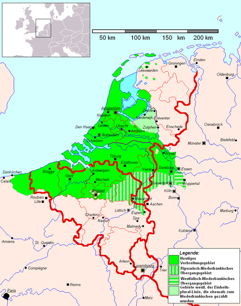
Deutsch: Karte mit dem Verbreitungsgebiet des Niederfränkischen. English: Low Franconian |
| Date |
9 March 2008 (original upload date) |
| Source | Nach Franz Petri, Helmut de Boor und Herbert Frenzel in Die Kulturen der Niederlande und Skandinavien, Karte S. 8 |
| Author |
The original uploader was Et Mikkel at German Wikipedia. |
| Permission (Reusing this file) |
Die schraffierten Gebiete gelten nach oben genannter Quelle als Niederfränkisch-Ripuarisches Übergangsgebiet. Auch wurde in der belgischen Region Brüssel das Wallonische nicht eingezeichnet, da dieses hier unerheblich ist. |
| Other versions | Derivative works of this file: Niederfränkisches-Niederländisches Sprachgebiet.png |
Licensing[edit]
| This work has been released into the public domain by its author, Et Mikkel. This applies worldwide. In some countries this may not be legally possible; if so: |
Original upload log[edit]
The original description page was here. All following user names refer to de.wikipedia.
- 2008-03-09 15:45 Et Mikkel 845×1071×8 (75102 bytes) {{Information |Beschreibung = Karte mit dem Verbreitungsgebiet des [[Niederfränkisch]]en. |Quelle = Nach Franz Petri, Helmut de Boor und Herbert Frenzel in ''Die Kulturen der [[Niederlande]] und [[Skanidnavien]]'', Karte S. 8 |Urheber = selbst gezeichnet
File history
Click on a date/time to view the file as it appeared at that time.
| Date/Time | Thumbnail | Dimensions | User | Comment | |
|---|---|---|---|---|---|
| current | 19:53, 6 March 2015 | | 845 × 1,071 (58 KB) | MicBy67 (talk | contribs) | {{Information |Description ={{de|1=Deutsch-niederländische Grenze berichtigt, Platdietse Gebiete Belgiens hinzugefügt}} |Source =Wikipedia |Author =Et Mikkel |Date =Heute |Permission = |other_versions = }} |
| 13:44, 5 September 2009 |  | 845 × 1,071 (78 KB) | MicBy67 (talk | contribs) | ||
| 22:25, 23 August 2009 |  | 845 × 1,071 (78 KB) | MicBy67 (talk | contribs) | Kleinere Überarbeitungen (Ripuarisch-Niederfränkisches Übergangsgebiet (Südniederfränkisch) und Westfälisch-Niederfränkisches Übergangsgebiet (Ostbergisch) eingezeichnet. Südostniederfränkisch (Ripuarisch) herausgenommen. | |
| 19:47, 15 August 2009 |  | 845 × 1,071 (75 KB) | MicBy67 (talk | contribs) | ||
| 12:26, 15 August 2009 |  | 845 × 1,071 (75 KB) | MicBy67 (talk | contribs) | ||
| 22:51, 13 August 2009 |  | 845 × 1,071 (75 KB) | MicBy67 (talk | contribs) | ||
| 21:31, 13 August 2009 |  | 845 × 1,071 (71 KB) | MicBy67 (talk | contribs) | ||
| 21:22, 13 August 2009 |  | 845 × 1,071 (71 KB) | MicBy67 (talk | contribs) | {{Information |Description= |Source=eigene Arbeit |Date= |Author= Hardcore-Mike |Permission= |other_versions= }} | |
| 18:18, 20 December 2008 |  | 845 × 1,071 (62 KB) | Spazzo (talk | contribs) | edited by Spazzo some positions of cities corrected {{PD-user|Et Mikkel}} | |
| 08:44, 20 December 2008 |  | 845 × 1,071 (62 KB) | Spazzo (talk | contribs) |
You cannot overwrite this file.
File usage on Commons
The following page uses this file:
File usage on other wikis
The following other wikis use this file:
- Usage on de.wikipedia.org
- Usage on fr.wikipedia.org
- Usage on ja.wikipedia.org
- Usage on pcd.wikipedia.org
- Usage on wa.wikipedia.org