File:2011 Tohoku earthquake observed tsunami heights-2.png
Jump to navigation
Jump to search
Size of this preview: 656 × 600 pixels. Other resolutions: 263 × 240 pixels | 525 × 480 pixels | 700 × 640 pixels.
Original file (700 × 640 pixels, file size: 310 KB, MIME type: image/png)
Captions
Captions
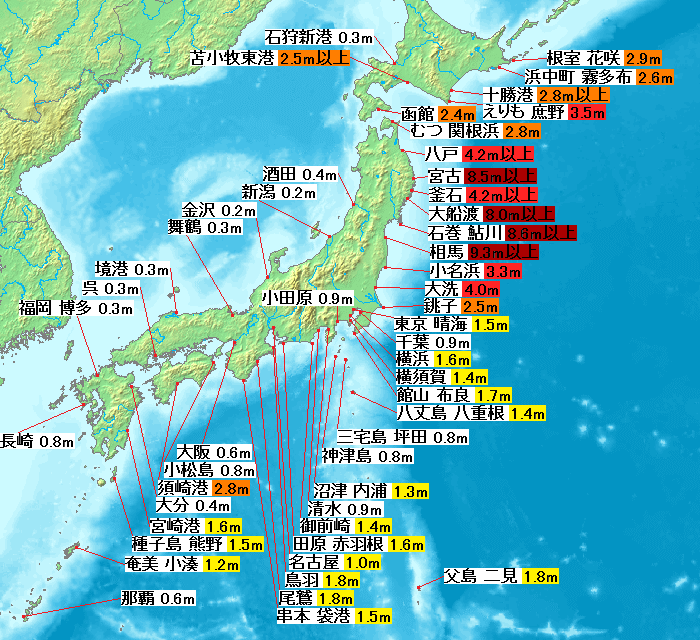
Map of 2011 Tohoku(Sendai) earthquake observed tsunami heights in Japan.
Summary[edit]
| Description |
English: Map of 2011 Tohoku(Sendai) earthquake observed tsunami heights in Japan.
日本語: 東北地方太平洋沖地震で観測された、験潮所における津波の高さ。 |
| Date | |
| Source | Own work, 2011 Tohoku earthquake observed tsunami heights.pngを修正, 気象庁 平成23年3月 地震・火山月報(防災編) |
| Author | Pekachu, As6022014 |
| Other versions | |
| Additional information | このファイルは File:2011 Tohoku earthquake observed tsunami heights.pngをその後発表された数値を基に修正したものです。 |
Licensing[edit]
I, the copyright holder of this work, hereby publish it under the following license:
This file is licensed under the Creative Commons Attribution-Share Alike 4.0 International license.
- You are free:
- to share – to copy, distribute and transmit the work
- to remix – to adapt the work
- Under the following conditions:
- attribution – You must give appropriate credit, provide a link to the license, and indicate if changes were made. You may do so in any reasonable manner, but not in any way that suggests the licensor endorses you or your use.
- share alike – If you remix, transform, or build upon the material, you must distribute your contributions under the same or compatible license as the original.
File history
Click on a date/time to view the file as it appeared at that time.
| Date/Time | Thumbnail | Dimensions | User | Comment | |
|---|---|---|---|---|---|
| current | 03:25, 25 May 2022 | | 700 × 640 (310 KB) | As6022014 (talk | contribs) | Uploaded own work with UploadWizard |
You cannot overwrite this file.
File usage on Commons
There are no pages that use this file.
File usage on other wikis
The following other wikis use this file:
- Usage on id.wikipedia.org
- Usage on ja.wikipedia.org