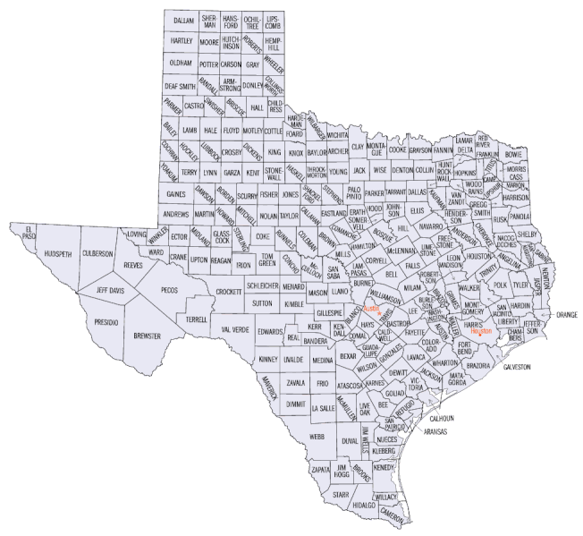
File:Texas counties map.gif
Jump to navigation
Jump to search

Size of this preview: 652 × 599 pixels. Other resolutions: 261 × 240 pixels | 522 × 480 pixels | 978 × 899 pixels.
Original file (978 × 899 pixels, file size: 105 KB, MIME type: image/gif)
Captions
Captions
Add a one-line explanation of what this file represents
Summary[edit]
- From the English Wikipedia (en:Image:Texas_counties_map.gif)
- De la Wikipedia inglesa (en:Image:Texas_counties_map.gif)
- Από της Αγγλικής Βικιπαίδειας (en:Image:Texas_counties_map.gif)
Licensing[edit]
This work is in the public domain in the United States because it is a work prepared by an officer or employee of the United States Government as part of that person’s official duties under the terms of Title 17, Chapter 1, Section 105 of the US Code.
Note: This only applies to original works of the Federal Government and not to the work of any individual U.S. state, territory, commonwealth, county, municipality, or any other subdivision. This template also does not apply to postage stamp designs published by the United States Postal Service since 1978. (See § 313.6(C)(1) of Compendium of U.S. Copyright Office Practices). It also does not apply to certain US coins; see The US Mint Terms of Use.
|
 | |
| This file has been identified as being free of known restrictions under copyright law, including all related and neighboring rights. | ||
File history
Click on a date/time to view the file as it appeared at that time.
| Date/Time | Thumbnail | Dimensions | User | Comment | |
|---|---|---|---|---|---|
| current | 04:12, 25 April 2010 | | 978 × 899 (105 KB) | AnonMoos (talk | contribs) | trying to fix MimeType problem, cropping margins |
| 21:47, 25 October 2005 | No thumbnail | (106 KB) | Benjaminb~commonswiki (talk | contribs) | * From the English Wikipedia (en:Image:Texas_counties_map.gif) * De la Wikipedia inglesa (en:Image:Texas_counties_map.gif) * Από την Αγγλικήν Βικιπαίδειαν (en:Image:Texas_counties_map.gif) |
You cannot overwrite this file.
File usage on Commons
There are no pages that use this file.
File usage on other wikis
The following other wikis use this file:
- Usage on ar.wikipedia.org
- مقاطعة كالدويل (تكساس)
- مقاطعة كالاهان (تكساس)
- مقاطعة كامرون (تكساس)
- مقاطعة كامب (تكساس)
- مقاطعة كارسون (تكساس)
- مقاطعة كاسترو (تكساس)
- مقاطعة تشامبرز (تكساس)
- مقاطعة شيروكي (تكساس)
- مقاطعة تشايلدريس (تكساس)
- مقاطعة كوتشران (تكساس)
- مقاطعة كوك (تكساس)
- مقاطعة كولمان (تكساس)
- مقاطعة كولين (تكساس)
- مقاطعة كولورادو (تكساس)
- مقاطعة كومال (تكساس)
- مقاطعة كورييل (تكساس)
- مقاطعة كوتل (تكساس)
- مقاطعة كرين (تكساس)
- مقاطعة كروسبي (تكساس)
- مقاطعة كولبيرسون (تكساس)
- مقاطعة ديف سميث (تكساس)
- مقاطعة دوفال (تكساس)
- مقاطعة إنسينال (تكساس)
- مقاطعة فانين (تكساس)
- مقاطعة غرير (تكساس)
- مقاطعة هاريس (تكساس)
- مقاطعة هيمبهيل (تكساس)
- مقاطعة لي (تكساس)
- مقاطعة ليبيرتي (تكساس)
- مقاطعة ليبسكوم (تكساس)
- مقاطعة لوفنغ (تكساس)
- مقاطعة لوبوك (تكساس)
- مقاطعة ستيرلنغ (تكساس)
- مقاطعة ويب (تكساس)
- Usage on cy.wikipedia.org
- Usage on en.wikipedia.org
- Usage on eo.wikipedia.org
- Usage on es.wikipedia.org
- Usage on fi.wikipedia.org
- Usage on fo.wikipedia.org
- Usage on frr.wikipedia.org
- Usage on fr.wikipedia.org
- Usage on he.wikipedia.org
- Usage on hu.wikipedia.org
View more global usage of this file.