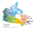
File:Political map of Canada it.svg

Original file (SVG file, nominally 512 × 443 pixels, file size: 984 KB)
Captions
Captions
 | This SVG image contains embedded raster graphics.[1] Such images are liable to produce inferior results when scaled to different sizes (as well as possibly being very inefficient in file size). If appropriate to do so, they should be replaced with images created using vector graphics. Note: This template is only supposed to be used if the SVG file mixes vector and raster graphics. If the SVG file only contains raster graphics {{FakeSVG}} is supposed to be used. See also {{TopoSVG}}. |
Summary[edit]
| DescriptionPolitical map of Canada it.svg |
Italiano: Una mappa del Canada che mostra le dieci province e i tre territori, e le rispettive capitali. (Proiezione conica conforme di Lambert da The Atlas of Canada)
English: A map of Canada exhibiting its ten provinces and three territories, and their capitals. (Lambert conformal conic projection from The Atlas of Canada) |
||
| Date | |||
| Source |
This file was derived from: |
||
| Author | Indil77 | ||
| Other versions |
Derivative works of this file: |
||
| SVG development InfoField | This icon was created with Inkscape.
|
Licensing[edit]
| Public domainPublic domainfalsefalse |
| |
This work has been released into the public domain by its author, Indil77, at the English Wikipedia project. This applies worldwide. In case this is not legally possible: |
Le dieci province
I tre territori
File history
Click on a date/time to view the file as it appeared at that time.
| Date/Time | Thumbnail | Dimensions | User | Comment | |
|---|---|---|---|---|---|
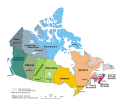
| current | 20:43, 13 December 2019 |  | 512 × 443 (984 KB) | Indil77 (talk | contribs) | fix text issue |
| 20:38, 13 December 2019 |  | 512 × 443 (982 KB) | Indil77 (talk | contribs) | texts converted into path | |
| 20:20, 13 December 2019 |  | 512 × 443 (965 KB) | Indil77 (talk | contribs) | fix scala e testo non visibile | |
| 20:00, 13 December 2019 |  | 512 × 443 (956 KB) | Indil77 (talk | contribs) | fix spaziatura scala | |
| 19:56, 13 December 2019 |  | 512 × 443 (956 KB) | Indil77 (talk | contribs) | fix traduzione province e territori | |
| 19:45, 13 December 2019 |  | 512 × 443 (956 KB) | Indil77 (talk | contribs) | User created page with UploadWizard |
You cannot overwrite this file.
File usage on Commons
There are no pages that use this file.
File usage on other wikis
The following other wikis use this file:
- Usage on als.wikipedia.org
- Usage on incubator.wikimedia.org
- Usage on it.wikipedia.org
Metadata
This file contains additional information such as Exif metadata which may have been added by the digital camera, scanner, or software program used to create or digitize it. If the file has been modified from its original state, some details such as the timestamp may not fully reflect those of the original file. The timestamp is only as accurate as the clock in the camera, and it may be completely wrong.
| Width | 100% |
|---|---|
| Height | 100% |