File:Flusssystemkarte Rhein 03.jpg
Jump to navigation
Jump to search
Size of this preview: 441 × 599 pixels. Other resolutions: 177 × 240 pixels | 353 × 480 pixels | 566 × 768 pixels | 754 × 1,024 pixels | 1,508 × 2,048 pixels | 3,198 × 4,342 pixels.
Original file (3,198 × 4,342 pixels, file size: 11.75 MB, MIME type: image/jpeg)
Captions
Captions
Add a one-line explanation of what this file represents
Summary[edit]
| Description |
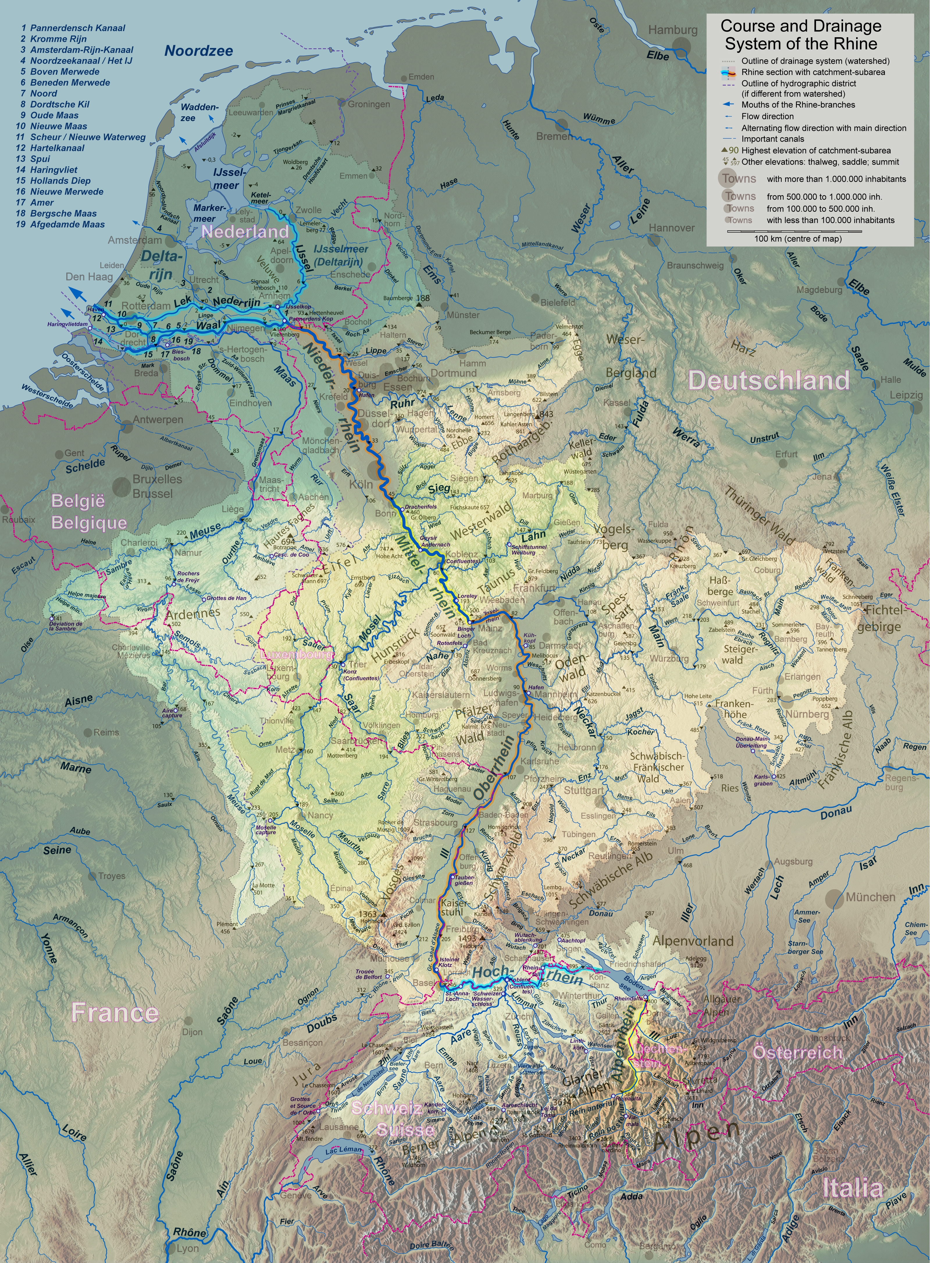
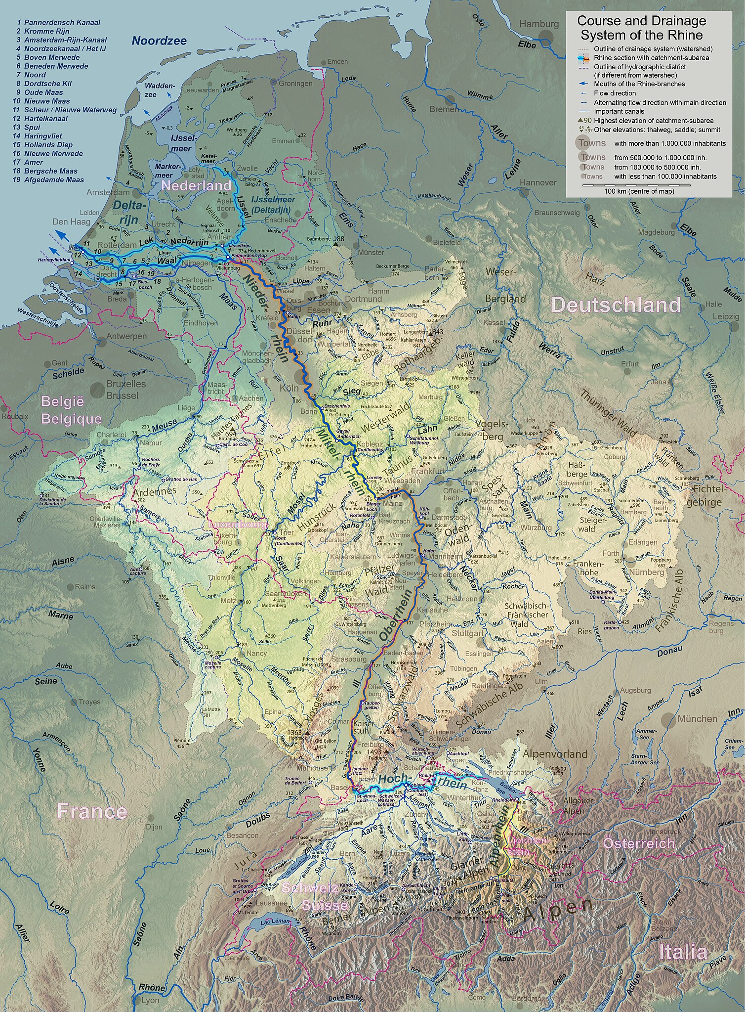
English: Rhine course and river system, place names in the countries' languages Deutsch: Rheinlauf und Flusssystem, beschriftet in jeweiligen Landessprachen Français : Cours du Rhin et son bassin versant, noms de lieux en langues nationales Nederlands: Verloop en rivierensysteem van de Rijn, plaatsnamen in landstalen |
| Date | |
| Source | Own work |
| Author | WWasser |
| Other versions | Versions in german, english, french, or dutch; for other languages the unlabelled version may be used. There are also less detailed maps of the river system with either german, english, french, dutch, or local names. A small version without names is available, too. |
| Camera location | | View this and other nearby images on: OpenStreetMap |
|---|
- Background relief created with Google Maps-For-Free SRTM3 Webserver
- Topography derived from Open Street Map
- Outlines of catchment areas derived from relief data (in the Netherlands also taken from several ICPR (International Commission for the Protection of the Rhine)- and Rijkswaterstaat-publications)
Licensing[edit]
I, the copyright holder of this work, hereby publish it under the following license:
This file is licensed under the Creative Commons Attribution-Share Alike 3.0 Unported license.
- You are free:
- to share – to copy, distribute and transmit the work
- to remix – to adapt the work
- Under the following conditions:
- attribution – You must give appropriate credit, provide a link to the license, and indicate if changes were made. You may do so in any reasonable manner, but not in any way that suggests the licensor endorses you or your use.
- share alike – If you remix, transform, or build upon the material, you must distribute your contributions under the same or compatible license as the original.
File history
Click on a date/time to view the file as it appeared at that time.
| Date/Time | Thumbnail | Dimensions | User | Comment | |
|---|---|---|---|---|---|
| current | 18:24, 17 September 2017 | | 3,198 × 4,342 (11.75 MB) | WWasser (talk | contribs) | Albertkanaal, Aa (Dommel), frontier lines in Lake of Constance |
| 12:15, 18 April 2013 |  | 2,399 × 3,256 (4.72 MB) | WWasser (talk | contribs) | more details | |
| 16:23, 4 April 2013 |  | 2,131 × 2,895 (4.24 MB) | WWasser (talk | contribs) | legend and colours | |
| 13:45, 5 March 2013 |  | 2,131 × 2,893 (3.33 MB) | WWasser (talk | contribs) | some smaller rivers, elevations | |
| 13:17, 8 February 2013 |  | 2,132 × 2,895 (3.06 MB) | WWasser (talk | contribs) | {{Information |Description ={{en|1=colours improved}} |Source =own |Author =WWasser |Date = |Permission = |other_versions = }} | |
| 08:12, 8 February 2013 |  | 2,132 × 2,895 (3.1 MB) | WWasser (talk | contribs) | {{Information |Description ={{en|1=Rhine course and river system, place names in the countries' languages}} {{de|1=Rheinlauf und Flusssystem, beschriftet in jeweiligen Landessprachen}} {{fr|1=Cours du Rhin et son bassin versant, noms de lieux en lan... | |
| 16:04, 5 February 2013 |  | 4,262 × 5,790 (4.23 MB) | WWasser (talk | contribs) | User created page with UploadWizard |
You cannot overwrite this file.
File usage on Commons
The following page uses this file:
File usage on other wikis
The following other wikis use this file:
- Usage on am.wikipedia.org
- Usage on ast.wikipedia.org
- Usage on azb.wikipedia.org
- Usage on az.wiktionary.org
- Usage on bat-smg.wikipedia.org
- Usage on bo.wikipedia.org
- Usage on bs.wikipedia.org
- Usage on cs.wikipedia.org
- Usage on cv.wikipedia.org
- Usage on es.wikipedia.org
- Usage on fi.wikipedia.org
- Usage on hr.wikipedia.org
- Usage on hu.wikipedia.org
- Usage on id.wikipedia.org
- Usage on ie.wikipedia.org
- Usage on it.wikipedia.org
- Usage on jv.wikipedia.org
- Usage on kbp.wikipedia.org
- Usage on lt.wikipedia.org
- Usage on ms.wikipedia.org
- Usage on mwl.wikipedia.org
- Usage on nn.wikipedia.org
- Usage on no.wikipedia.org
- Usage on os.wikipedia.org
- Usage on pa.wikipedia.org
- Usage on pl.wikipedia.org
- Usage on pt.wikipedia.org
- Usage on ro.wikipedia.org
- Usage on sk.wikipedia.org
- Usage on sl.wikipedia.org
- Usage on sr.wikipedia.org
- Usage on sv.wikipedia.org
- Usage on uk.wikipedia.org
- Usage on zh.wikipedia.org