File:European Union without internal borders.svg
Jump to navigation
Jump to search

Size of this PNG preview of this SVG file: 713 × 600 pixels. Other resolutions: 285 × 240 pixels | 571 × 480 pixels | 913 × 768 pixels | 1,218 × 1,024 pixels | 2,435 × 2,048 pixels | 2,045 × 1,720 pixels.
Original file (SVG file, nominally 2,045 × 1,720 pixels, file size: 7.34 MB)
Captions
Captions
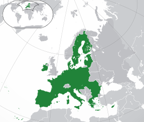
European Union, without any internal borders between member states
Summary[edit]
| Description |
European Union (locator map image) (green) European Union
(gray) Europe
(silver) Surrounding region
|
| Date | |
| Source |
This W3C-unspecified vector image was created with Inkscape . |
| Author | User:Robert Laymont |
| Other versions |
|
.svg)

Licensing[edit]
I, the copyright holder of this work, hereby publish it under the following licenses:
This file is licensed under the Creative Commons Attribution-Share Alike 3.0 Unported license.
- You are free:
- to share – to copy, distribute and transmit the work
- to remix – to adapt the work
- Under the following conditions:
- attribution – You must give appropriate credit, provide a link to the license, and indicate if changes were made. You may do so in any reasonable manner, but not in any way that suggests the licensor endorses you or your use.
- share alike – If you remix, transform, or build upon the material, you must distribute your contributions under the same or compatible license as the original.

|
Permission is granted to copy, distribute and/or modify this document under the terms of the GNU Free Documentation License, Version 1.2 or any later version published by the Free Software Foundation; with no Invariant Sections, no Front-Cover Texts, and no Back-Cover Texts. A copy of the license is included in the section entitled GNU Free Documentation License. |
You may select the license of your choice.
File history
Click on a date/time to view the file as it appeared at that time.
| Date/Time | Thumbnail | Dimensions | User | Comment | |
|---|---|---|---|---|---|
| current | 10:19, 23 May 2020 | | 2,045 × 1,720 (7.34 MB) | Thayts (talk | contribs) | Fixed viewport outline on inserted map |
| 04:12, 1 February 2020 |  | 2,045 × 1,720 (7.27 MB) | Rob984 (talk | contribs) | UK and Gibraltar have left the EU. New base which includes all of Portugal's islands within frame, as well as Arctic Russian islands part of Europe. | |
| 01:50, 10 March 2017 |  | 2,045 × 1,720 (7.3 MB) | Geom10 (talk | contribs) | fixed Cyprus and disputed borders | |
| 01:23, 10 March 2017 |  | 2,045 × 1,720 (7.32 MB) | Geom10 (talk | contribs) | fixed Cyprus and Slovenia | |
| 15:25, 9 August 2014 |  | 2,045 × 1,720 (7.32 MB) | Rob984 (talk | contribs) | Improved version: More accurate coastline, borders, etc. Added Gradient and Longitude and latitude lines. Sudan border. | |
| 07:30, 1 July 2013 |  | 2,045 × 1,720 (2.46 MB) | Klodde (talk | contribs) | Croatia | |
| 10:20, 13 August 2012 |  | 2,045 × 1,720 (2.46 MB) | Robert Laymont (talk | contribs) | Antarctica now appears correctly in the minimap. | |
| 07:13, 13 August 2012 |  | 2,045 × 1,720 (2.48 MB) | Robert Laymont (talk | contribs) |
You cannot overwrite this file.
File usage on Commons
The following 14 pages use this file:
- European Union
- File:European Union.svg
- File:European Union (blue).svg
- Category:2024 in the European Union
- Category:Civil servants of the European Union
- Category:Education in the European Union
- Category:Electric power in the European Union
- Category:European Union
- Category:European Union in the 1990s
- Category:European Union in the 2000s
- Category:European Union in the 2010s
- Category:European Union in the 2020s
- Category:History of the European Union by decade
- Category:Maps of the European Union
File usage on other wikis
The following other wikis use this file:
- Usage on ar.wikipedia.org
- Usage on arz.wikipedia.org
- Usage on ast.wikipedia.org
- Usage on diq.wikipedia.org
- Usage on en.wikipedia.org
- Usage on eu.wikipedia.org
- Usage on fr.wikipedia.org
- Usage on fr.wikinews.org
- Usage on ga.wikipedia.org
- Usage on gl.wikipedia.org
- Usage on ha.wikipedia.org
- Usage on ia.wikipedia.org
- Usage on incubator.wikimedia.org
- Usage on kab.wikipedia.org
- Usage on kk.wikipedia.org
- Usage on ku.wikipedia.org
- Usage on lmo.wikipedia.org
- Usage on mdf.wikipedia.org
- Usage on pt.wikipedia.org
- Usage on www.wikidata.org