File:Rete autostradale italiana-labeled.svg
Jump to navigation
Jump to search

Size of this PNG preview of this SVG file: 425 × 500 pixels. Other resolutions: 204 × 240 pixels | 408 × 480 pixels | 653 × 768 pixels | 870 × 1,024 pixels | 1,741 × 2,048 pixels.
Original file (SVG file, nominally 425 × 500 pixels, file size: 50 KB)
Captions
Captions
Add a one-line explanation of what this file represents
| Description |
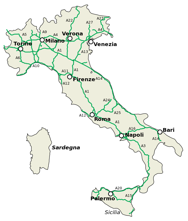
English: Italian motorway network (motorways, distributions, connections, orbitals). Español: Red de autopistas italianas (carreteras, distribuciones, conexiones, circunvalaciónes). Italiano: Rete autostradale italiana (autostrade, diramazioni, raccordi, tangenziali). |
| Date | (UTC) |
| Source | |
| Author |
|
| This is a retouched picture, which means that it has been digitally altered from its original version. Modifications: Added labels for most important motorways, and some cities.. The original can be viewed here: Rete autostradale italiana.svg:
|
I, the copyright holder of this work, hereby publish it under the following license:
This file is licensed under the Creative Commons Attribution-Share Alike 2.5 Generic license.
- You are free:
- to share – to copy, distribute and transmit the work
- to remix – to adapt the work
- Under the following conditions:
- attribution – You must give appropriate credit, provide a link to the license, and indicate if changes were made. You may do so in any reasonable manner, but not in any way that suggests the licensor endorses you or your use.
- share alike – If you remix, transform, or build upon the material, you must distribute your contributions under the same or compatible license as the original.
Sources[edit]
Used this map for the motorway numbers.
Original upload log[edit]
This image is a derivative work of the following images:
- File:Rete_autostradale_italiana.svg licensed with Cc-by-sa-2.5
- 2009-08-25T08:18:59Z Xander89 425x500 (27231 Bytes) little corrections (T1, T4 added, some minor RA removed)
- 2009-07-09T18:34:00Z Xander89 425x500 (27192 Bytes) forgotten a ra.
- 2009-07-09T11:14:16Z Xander89 425x500 (27382 Bytes) RA removed from the map: they are not part of the "Autostrade" system
- 2009-06-25T13:44:21Z Xander89 425x500 (31999 Bytes) added Mestre's ''Passante''
- 2006-11-01T18:41:39Z ColdShine 425x500 (30922 Bytes)
- 2006-10-31T01:26:32Z ColdShine 580x681 (46407 Bytes)
- 2006-10-25T12:35:17Z ColdShine 580x681 (75025 Bytes)
- 2006-10-25T12:30:03Z ColdShine 580x681 (75040 Bytes) {{Information| |Description= {{en|Italian motorway network (motorways, distributions, connections, orbitals).}} {{es|Red de autopistas italianas (carreteras, distribuciones, conexiones, circunvalaciónes).}} {{it|Rete autostr
Uploaded with derivativeFX
File history
Click on a date/time to view the file as it appeared at that time.
| Date/Time | Thumbnail | Dimensions | User | Comment | |
|---|---|---|---|---|---|
| current | 23:23, 26 November 2009 | | 425 × 500 (50 KB) | Classical geographer (talk | contribs) | {{Information |Description={{en|Italian motorway network (motorways, distributions, connections, orbitals).}} {{es|Red de autopistas italianas (carreteras, distribuciones, conexiones, circunvalaciónes).}} {{it|Rete autostradale italiana (autostrade, dira |
You cannot overwrite this file.
File usage on Commons
The following page uses this file:
File usage on other wikis
The following other wikis use this file:
- Usage on de.wikipedia.org
- Usage on fr.wikipedia.org
- Usage on hu.wikipedia.org
- Usage on ja.wikipedia.org
- Usage on nl.wikivoyage.org