File:Chariot spread.png
Jump to navigation
Jump to search
No higher resolution available.
Chariot_spread.png (400 × 231 pixels, file size: 154 KB, MIME type: image/png)
Captions
Captions
Add a one-line explanation of what this file represents
| Description |
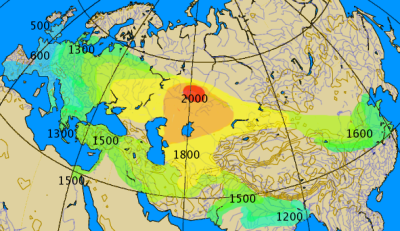
Historical spread of the chariot. This map combines various classes of information, historical and archaeological. The 'isochrones' as given should not be considered more than rough approximations, give or take a century.
|
||||||||
| Date | |||||||||
| Source | Own work by by en:User:Dbachmann | ||||||||
| Author | by en:User:Dbachmann | ||||||||
| Permission (Reusing this file) |
|
||||||||
| Other versions |
|


File history
Click on a date/time to view the file as it appeared at that time.
| Date/Time | Thumbnail | Dimensions | User | Comment | |
|---|---|---|---|---|---|
| current | 04:00, 27 September 2021 | | 400 × 231 (154 KB) | GPinkerton (talk | contribs) | Reverted to version as of 14:14, 17 August 2005 (UTC) COM:CROP |
| 19:28, 2 May 2021 |  | 400 × 231 (161 KB) | Claude Zygiel (talk | contribs) | North Africa too (Raymond Vaufrey, Préhistoire de l'Afrique, tome II, Service des Publications de l'Université de Tunis, 1969) | |
| 14:14, 17 August 2005 |  | 400 × 231 (154 KB) | Dbachmann (talk | contribs) | correction, labels | |
| 07:14, 17 August 2005 |  | 350 × 202 (119 KB) | Dbachmann (talk | contribs) | by en:User:Dbachmann {{GFDL}} |
You cannot overwrite this file.
File usage on Commons
The following 6 pages use this file:
File usage on other wikis
The following other wikis use this file:
- Usage on az.wikipedia.org
- Usage on ba.wikipedia.org
- Usage on bn.wikipedia.org
- Usage on ca.wikipedia.org
- Usage on cs.wikipedia.org
- Usage on da.wikipedia.org
- Usage on de.wikipedia.org
- Usage on en.wikipedia.org
- Usage on es.wikipedia.org
- Usage on eu.wikipedia.org
- Usage on fa.wikipedia.org
- Usage on fi.wikipedia.org
- Usage on fi.wikibooks.org
- Usage on fr.wikipedia.org
- Usage on hak.wikipedia.org
- Usage on he.wikipedia.org
- Usage on hu.wikipedia.org
- Usage on hy.wikipedia.org
View more global usage of this file.
Metadata
Categories:
- Ancient four-wheeled chariots
- War chariots
- Maps of the Sintashta culture
- Archaeological maps
- Maps showing 2nd-millennium BC history
- Maps showing 1st-millennium BC history
- Maps showing 20th-century BC history
- Maps showing 19th-century BC history
- Maps showing 18th-century BC history
- Maps showing 17th-century BC history
- Maps showing 16th-century BC history
- 12th century BC
- 10th century BC
- 6th century BC
- 5th century BC
- Maps of the Bronze Age in China
- Isochrone maps
- Transport statistics