File:Alex K Halych-Volhynia general.png
Jump to navigation
Jump to search
No higher resolution available.
Alex_K_Halych-Volhynia_general.png (462 × 365 pixels, file size: 43 KB, MIME type: image/png)
Captions
Captions
Add a one-line explanation of what this file represents
Summary[edit]

|
This historical map image could be re-created using vector graphics as an SVG file. This has several advantages; see Commons:Media for cleanup for more information. If an SVG form of this image is available, please upload it and afterwards replace this template with
{{vector version available|new image name}}.
It is recommended to name the SVG file “Alex K Halych-Volhynia general.svg”—then the template Vector version available (or Vva) does not need the new image name parameter. |
| Description |
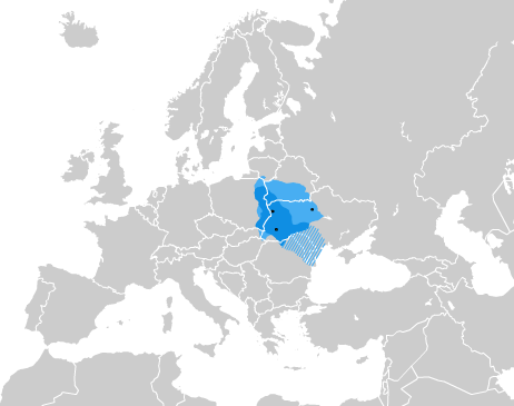
Карта Галицько-Волинського князівства English: Kingdom of Galicia–Volhynia in the 13th/14th century Deutsch: Das Fürstentum Halytsch-Wolhynien im 13.–14. Jahrhundert |
| Date | |
| Source | self-made =* Крип'якевич І. Галицько-волинське князівство. Київ, 1984. |
| Author | Alex Tora |
Licensing[edit]
I, the copyright holder of this work, hereby publish it under the following licenses:

|
Permission is granted to copy, distribute and/or modify this document under the terms of the GNU Free Documentation License, Version 1.2 or any later version published by the Free Software Foundation; with no Invariant Sections, no Front-Cover Texts, and no Back-Cover Texts. A copy of the license is included in the section entitled GNU Free Documentation License. |
This file is licensed under the Creative Commons Attribution-Share Alike 3.0 Unported, 2.5 Generic, 2.0 Generic and 1.0 Generic license.
- You are free:
- to share – to copy, distribute and transmit the work
- to remix – to adapt the work
- Under the following conditions:
- attribution – You must give appropriate credit, provide a link to the license, and indicate if changes were made. You may do so in any reasonable manner, but not in any way that suggests the licensor endorses you or your use.
- share alike – If you remix, transform, or build upon the material, you must distribute your contributions under the same or compatible license as the original.
You may select the license of your choice.
File history
Click on a date/time to view the file as it appeared at that time.
| Date/Time | Thumbnail | Dimensions | User | Comment | |
|---|---|---|---|---|---|
| current | 16:31, 29 January 2022 | | 462 × 365 (43 KB) | Moodylo333 (talk | contribs) | Reverted to version as of 03:41, 19 August 2007 (UTC): COM:CROP |
| 15:58, 19 February 2019 |  | 462 × 365 (41 KB) | Augustus-ua (talk | contribs) | Уточнено кордони за Темушев Н. В. Вялікае княства Літоўскае: Энцыклапедыя; Лоза І. Історичний Атлас України, Вортман Д. на likbez.org.ua | |
| 18:40, 17 January 2019 |  | 462 × 365 (44 KB) | Claude Zygiel (talk | contribs) | Without soviet dams; Montenegro; maximal extension lighter, influence area bluebordered, since Grosser Atlas zur Weltgeschichte, Westermann 1985 - ISBN 3-14-100919-8; Putzger historischer Weltatlas, Cornelsen 1990 - ISBN 3-464-00176-8 and Atlas historique Georges Duby, Larousse Paris 1987 - ISBN 2-03-503009-9. | |
| 03:41, 19 August 2007 |  | 462 × 365 (43 KB) | Alex Tora (talk | contribs) | {{Information |Description=Карта Галицько-Волинського князівства |Source=self-made =* [http://litopys.org.ua/krypgvol/krypgv03.htm Крип'якевич І. |
You cannot overwrite this file.
File usage on Commons
The following 5 pages use this file:
File usage on other wikis
The following other wikis use this file:
- Usage on ar.wikipedia.org
- Usage on ast.wikipedia.org
- Usage on az.wikipedia.org
- Usage on ba.wikipedia.org
- Usage on bg.wikipedia.org
- Usage on da.wikipedia.org
- Usage on de.wikipedia.org
- Usage on el.wikipedia.org
- Usage on en.wikipedia.org
- Usage on es.wikipedia.org
- Usage on et.wikipedia.org
- Usage on eu.wikipedia.org
- Usage on fr.wikipedia.org
- Usage on gl.wikipedia.org
- Usage on he.wikipedia.org
- Usage on hy.wikipedia.org
- Usage on ja.wikipedia.org
- Usage on la.wikipedia.org
- Usage on lt.wikipedia.org
- Usage on lv.wikipedia.org
- Usage on mk.wikipedia.org
- Usage on nl.wikipedia.org
- Usage on pl.wikipedia.org
- Usage on ru.wikipedia.org
- Usage on ru.wikiversity.org
- Usage on sr.wikipedia.org
View more global usage of this file.