File:טווח ירי הרקטות מרצועת עזה.png
Jump to navigation
Jump to search

Size of this preview: 323 × 599 pixels. Other resolutions: 129 × 240 pixels | 259 × 480 pixels | 414 × 768 pixels | 552 × 1,024 pixels | 1,849 × 3,428 pixels.
Original file (1,849 × 3,428 pixels, file size: 917 KB, MIME type: image/png)
Captions
Captions
Add a one-line explanation of what this file represents
Summary[edit]
| Description |
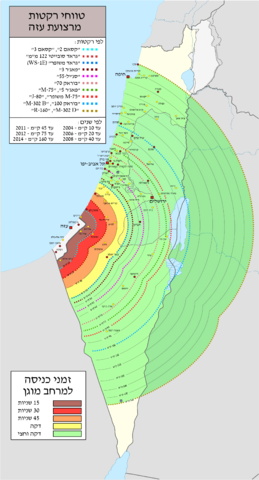
עברית: טווח ירי רקטות על ישראל מרצועת עזה 10-160 ק"מ.
|
| Date | |
| Source | מפת בסיס: Israel location map.svg by NordNordWest |
| Author | Dekel E |
| Other versions |
|
.svg)
.png)

Licensing[edit]
This file is licensed under the Creative Commons Attribution-Share Alike 3.0 Unported license.
- You are free:
- to share – to copy, distribute and transmit the work
- to remix – to adapt the work
- Under the following conditions:
- attribution – You must give appropriate credit, provide a link to the license, and indicate if changes were made. You may do so in any reasonable manner, but not in any way that suggests the licensor endorses you or your use.
- share alike – If you remix, transform, or build upon the material, you must distribute your contributions under the same or compatible license as the original.

|
Permission is granted to copy, distribute and/or modify this document under the terms of the GNU Free Documentation License, Version 1.2 or any later version published by the Free Software Foundation; with no Invariant Sections, no Front-Cover Texts, and no Back-Cover Texts. A copy of the license is included in the section entitled GNU Free Documentation License. |
Original upload log[edit]
The original description page was here. All following user names refer to he.wikipedia.
| Date/Time | Dimensions | User | Comment |
|---|---|---|---|
| 2014-07-19 09:39 | 1849×3428× (845342 bytes) | Dekel E | +סג'יל 55 |
| 2014-07-19 07:51 | 1849×3428× (845628 bytes) | Dekel E | + קריית אתא, קריית מוצקין, נס ציונה, שפרעם |
| 2014-07-19 07:16 | 1849×3428× (840004 bytes) | Dekel E | |
| 2014-07-19 06:56 | 1849×3428× (841349 bytes) | Dekel E | הוספת אריאל וטול כרם |
| 2014-07-18 20:18 | 1849×3428× (839831 bytes) | Dekel E | שיפור האיכות |
| 2014-07-18 20:03 | 615×1142× (232937 bytes) | Dekel E | +רמת השרון |
| 2014-07-18 19:27 | 615×1142× (232571 bytes) | Dekel E | הגדלת טווחים, הוספת ערים |
| 2014-07-18 17:00 | 615×1142× (158274 bytes) | Dekel E | == תקציר == {{מידע |תיאור=טווח ירי רקטות על ישראל |מקור=מפת בסיס: [[:קובץ:Israel location map.svg|Israel location map.svg]] |תאריך יצירה=18/07/2014 |יוצר=[[משתמש:Dekel E|Dekel E]] |אי... |
File history
Click on a date/time to view the file as it appeared at that time.
| Date/Time | Thumbnail | Dimensions | User | Comment | |
|---|---|---|---|---|---|
| current | 14:53, 24 August 2014 | | 1,849 × 3,428 (917 KB) | Orwell1 (talk | contribs) | add more rockets |
| 18:31, 11 August 2014 |  | 1,849 × 3,428 (894 KB) | Orwell1 (talk | contribs) | +Kfar Yona | |
| 07:50, 10 August 2014 |  | 1,849 × 3,428 (890 KB) | Orwell1 (talk | contribs) | + | |
| 19:33, 20 July 2014 |  | 1,849 × 3,428 (826 KB) | Orwell1 (talk | contribs) | Transferred from he.wikipedia |
You cannot overwrite this file.
File usage on Commons
The following 2 pages use this file:
File usage on other wikis
The following other wikis use this file:
- Usage on he.wikipedia.org
- רצועת עזה
- האינתיפאדה השנייה
- קסאם
- מבצע קשת בענן
- ציר פילדלפי
- מבצע ימי תשובה
- אסון הנגמ"שים
- מבצע גשמי קיץ
- עוטף עזה
- גדר המערכת סביב רצועת עזה
- מבצע חורף חם
- מבצע עופרת יצוקה
- הלחימה ברצועת עזה מההתנתקות עד מבצע עופרת יצוקה
- מתקפת הטרור בדרום ישראל (2011)
- מבצע הד חוזר
- הלחימה ברצועת עזה בין מבצע עופרת יצוקה למבצע עמוד ענן
- מתקפת הטרור במפגש הגבולות ישראל–מצרים–רצועת עזה
- תבנית:הלחימה ברצועת עזה
- מבצע עמוד ענן
- M-75
- מנהרות לחימה ברצועת עזה
- M-302
- שיגורי רקטות מרצועת עזה לישראל
- הלחימה ברצועת עזה בין מבצע עמוד ענן למבצע צוק איתן
- מבצע צוק איתן
- J-80
- קרב שג'אעייה (2014)
- R-160
- סג'יל 55
- אירועי מבצע צוק איתן
- הלחימה ברצועת עזה לאחר מבצע צוק איתן
- פיצוץ מנהרת הטרור ליד כיסופים
- העימותים בגבול ישראל–רצועת עזה (2018–2021)
- המעבדה הטכנולוגית לגילוי ואיתור מנהרות (פיקוד הדרום)
- אירועי העימותים בגבול ישראל–רצועת עזה (2018–2021)
- מבצע חגורה שחורה
- מבצע אתגר כפול
- מבצע שומר החומות
- הלחימה ברצועת עזה בין מבצע שומר החומות למלחמת חרבות ברזל
- מבצע עלות השחר
- אל-קודס (רקטה)
- מבצע מגן וחץ
- מלחמת חרבות ברזל
- עיאש 250
- טיוטה:פינוי צפון רצועת עזה
- טיוטה:הפצצת מחנה הפליטים ג'בליה
- משתמש:Jaredscribe/מלחמת חמאס-ישראלי-2023
- שיגורים כושלים מרצועת עזה